I sat shifting through some website material I found after receiving a postcard about the upcoming Downtown Bus + Rail Planning for January 26th, 6-8pm at Redmond City Hall. I was instantly curious and dug into the link on the post card.
https://redmond.gov/lightrailextension
But what I found was what I’d been curious about for some time. What in the world is going on with the transformation of downtown Redmond. First things first, let me show you a map I created first to get an idea of where and what we’re talking about.
First, Redmond in comparison to where Seattle is. Seattle is the large red zone to the left on the map that is labeled Seattle.
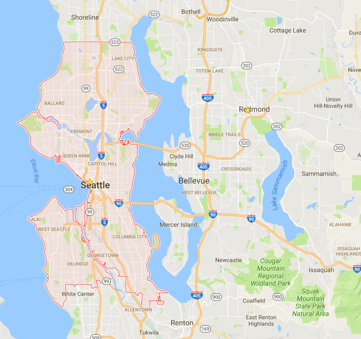
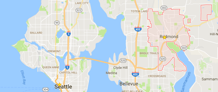
Looking to the right, I’ve now highlighted the city of Redmond. For more details on Redmond check out the Wikipedia page. It states that Redmond is just barely a city at 54k + people. A fair size for a place that is primarily suburbs.
Now that we can see this space and have some comparison to Seattle, let’s zoom in to the area we’re actually going to be discussing. First, a mid-level zoom into the Redmond. The area I’ve drawn a square around is what can be considered urban.
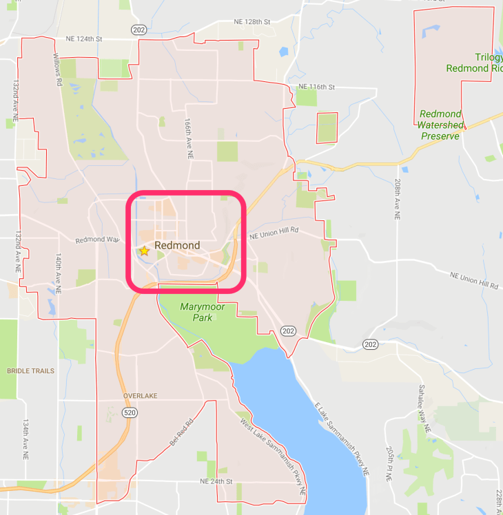
All the area around that square is basically sprawling single family homes with very few amenities of any sort, unwalkable neighborhoods (unless you want to just walk in circles), and lots of apartments and I suppose some are condominiums. All in all, almost your standard suburbs, the huge difference between these and your standard American suburbs is that they’re full of Microsofties that pay huge sums for average quality abodes and lots of people Microsoft pulls into the area from other countries and from the US itself that generally end up in the apartments. One could say it’s a more educated population that your average suburb, but a suburb none the less. An emphasis on auto-dependence, few truly walkable areas, lots of low and mid-speed auto wrecks daily, high speed arterials at 30+ mph that have a fatality count unto themselves, and other related such statistics. More on all that later, I want to talk about the awesome part of the Redmond, it’s heart and core. After all, that’s what this light rail and bus connection work is all about.
Below is a map of the general town, or city core, of Redmond. The orange or tan colored spaces are commercial, the green is green space and parks, and the gray is primarily residential. To the left hand side you can also see the man-made Sammamish River running north, with the small sliver connecting in the south called Bear Creek.
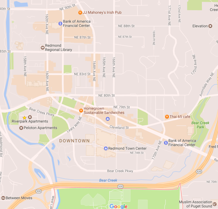
On this map 520 is basically a massive multi-lane high speed highway. (freeway?) It severs the heart of Redmond from the huge Marymoor Park to the south, but fortunately there is a mixed use path to the far left that goes under the freeway that will get you there.
I navigated to their link and found a page written about the prospective light rail line. At the header of the page, it had the following information.
Light Rail is Coming to Downtown and Southeast Redmond
Location:
- Downtown Redmond Station in Redmond Central Connector Corridor
- Southeast Redmond Station adjacent to SR 520 near west end of NE 70th St.
Project Phase: Preliminary Design
Estimated Timeline: Preliminary design 2017-18; final design, construction and testing 2019-2024; service targeted to begin 2024
Additional Project Information: available on Sound Transit’s ST3 website
Interesting indeed, and also interesting that the target date for opening this is merely a year after the completion of the other massive part of east link. At this point, theoretically, in 2024 when I’m a billion years old this will open, and it’ll likely be extremely useful!
At this point I realized I’m interested enough I may just attend this meeting. Actually, I’m real keen on attending. Then I saw this picture and I got even more intrigued.
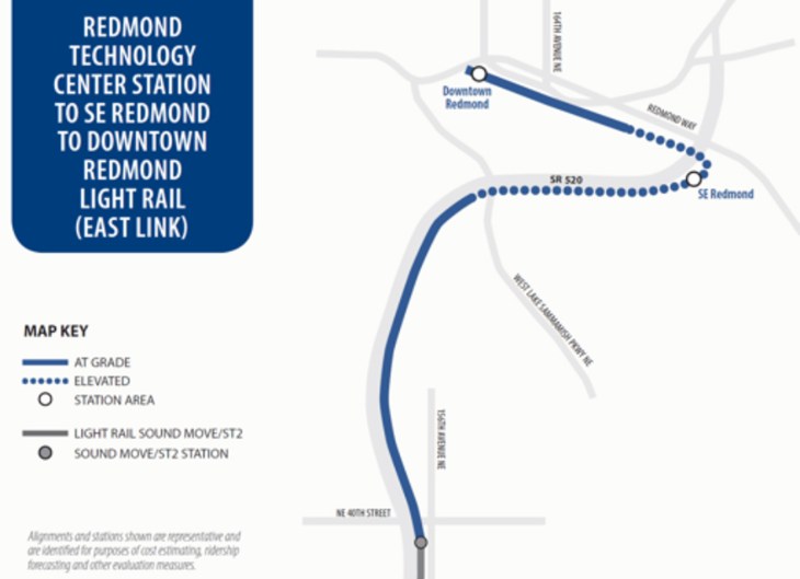
I have a few immediate thoughts.
- Oh god highways ruin another good thing. Look at that completely asinine, excessive, wasteful, time sucking, horrible turn cutting into SE Redmond and then into Downtown Redmond. If this were focused on timeliness and use it would connect downtown Redmond, and the Redmond Transit Center about 5 blocks away, with a straight raised cut OVER THE BLOODY HIGHWAY BLOCKING ITS PATH! Ok, I’ll settle down now. Breathing…
- There’s the 40th street stop, which is where the current 545 Express bus stops and is often stuck in traffic. Having something connect Redmond to Overlake and then onward into Seattle will be huge! If I’m still living anywhere near these parts in 2024 it would be a life saver.
I read onward on the site and found the parts that I actually find even more interesting. Currently, Redmond is a fairly walkable downtown, except there are some huge glaring issues of 1950s era thinking going on. Here’s a shortlist:
- Redmond was redesigned somewhere in the last 100 years to be super auto-centric. There are two arterials that run through the downtown focused on shoving cars through the downtown core. Not on walking, but on shoving cars through. Some of the worst auto-focused thinking is brought into play here with two one way streets, Cleveland and Redmond Way.
- Most of the new streets are also large, but the best we can hope for with today’s design. They’re large 3 lanes, one middle turn, with a lane on each side plus bike lanes and sidewalks. Not exactly comfortable walking, especially for elderly, handicap, or anyone not fully able bodied and ready for a brisk street crossing, but they’re pleasant enough for modern American streets.
- Almost every store, except for the 2-3 blocks of old town buildings, has excessive parking. The new the buildings, and especially the soul sucking Redmond Town Center have massive parking for thousands with barely half of that used during the peak of Christmas shopping. It’s a case of building wrong for the intent of having foot traffic. Redmond Town Center even amplifies that by being a mutant version of an outdoor and indoor mall with a giant multi-deck parking garage surrounding the actual open air walkable mall on every side and severing it from what is actually Redmond. It’s a sad case of misguided design poorly implemented for the intent of creating a walkable space because of it’s destructive use and overbuilding of massive parking everywhere.
Again, the summary of point 3 is the parking is vastly overbuilt and excessive in every way. 80% could be destroyed tomorrow and rebuilt as commercial and residential mixed use and Redmond would in short order – likely just a few years – become a thriving urban space among a sea of suburbia on the far outskirts of Seattle. That’s where we come full circle to the part that caught my attention on the site after looking through the light rail content.
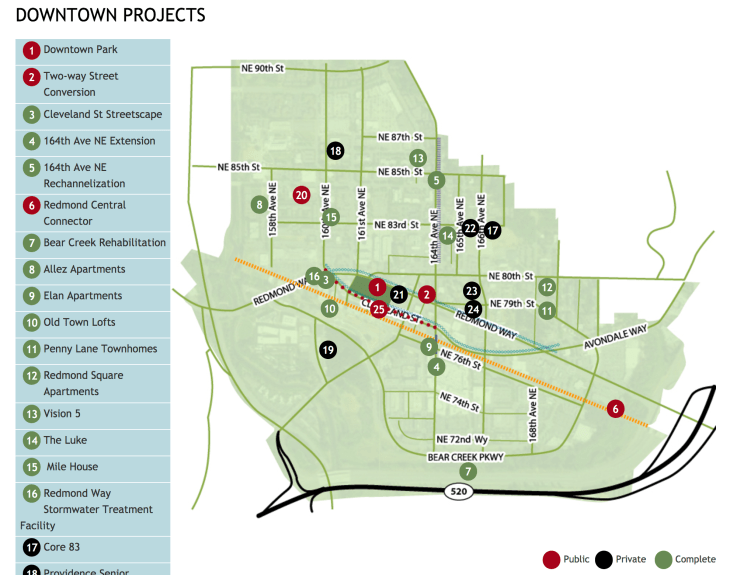
Further under the map, or by clicking on the numbers on this page I found a few key parts that are going to help walkability in Redmond in a massive way.
- Two-way Street Conversion – They’re actually, at some point in the future going to turn Redmond Way into the one-way automobile sewer of pedestrian danger into a two way street that will actually be usable and useful to the nearby businesses! I’m FREAKING STOKED!
- Cleveland Streetscape (Completed) – This is already done and its beautiful honestly. They’ve also fixed the street crossing lights to focus on pedestrians. it is actually truly wonderful to walk around this street. For pedestrians of all abilities and all ages, it’s really nice. Slowly, there’s more and more life on this street too, which is great!
There are more items there, but that’s it for this article. I found most of this surprising, and yet very reassuring that somebody in Redmond actually has a clue and is doing really great work. Hats off to them and kudos to a smarter, better, more active, more passionate, interesting, lively, and healthier future for Redmond.
Until another time, Transit Sleuth signing off.
