Yup, I’m writing about 3rd places again.
There’s a word for the place that isn’t home and isn’t work. Ray Oldenburg called it the third place back in 1989, in a book called The Great Good Place, and the idea has been quietly haunting American life ever since. The corner tavern. The diner where the waitress knows your order. The barbershop, the bakery, the bookshop with the good chairs. The plaza where old men argue about nothing for three hours. The place you go for no reason except that other people are also there for no reason.
Here’s the thing about third places. They aren’t a business model. They’re a condition. And in America we spent seventy years methodically dismantling the conditions, then acted surprised when the places went away.
What a Third Place Actually Is
Oldenburg was specific, and the specifics matter, because we’ve since let corporations launder the term into meaninglessness.
A real third place is neutral ground. Nobody’s the host, nobody’s the guest, and you don’t owe anyone anything to be there. It’s a leveler, so the guy who runs the plumbing supply and the woman who runs the county office are just two people at the counter. The main activity is conversation. There are regulars who give the place its character, but a newcomer can walk in and belong by the second visit. It’s easy to get to, it’s cheap or free, the mood is playful, and it functions as a home away from home.
Read that list again and notice how much of it is physical. Easy to get to. Cheap to enter. Somewhere you can loiter without a transaction. Those aren’t vibes. They’re land-use decisions, price structures, and transportation networks. Which is exactly why they died the way they did.
We Didn’t Lose Them by Accident
We zoned them out. Single-use Euclidean zoning, the American default, makes it illegal to put a café on your residential street. The whole postwar model separates where you sleep from where you work from where you buy a gallon of milk, and mandates a car trip between each. A third place needs to be a two-minute walk from a few hundred front doors. In most of America, building that is against the law. There’s nothing to walk to because we outlawed the walk-to.
We drove past them. Once every trip is a car trip, the third place has to compete for a parking spot and a fifteen-minute drive. The corner bar within stumbling distance becomes a destination bar with a DUI risk. The spontaneous “I’ll swing by” evaporates, because nothing is on the way to anything when everything requires the car.
We priced them out. The independent diner, the used bookstore, the dive that let you nurse one coffee for two hours all run on thin margins and cheap rent. Commercial rents don’t do cheap anymore. The economics of a space that wants you to linger without spending are brutal, and they lose every time to the space engineered for turnover.
We privatized leisure. TV, then cable, then streaming, then a supercomputer in every pocket. Each one made the couch a more complete substitute for going out. Why sit at the counter and risk small talk when the entire feed of human attention is right here, frictionless, no pants required.
Then COVID finished the job. Remote work didn’t just hollow out the second place. It took the informal third places that lived off office-district foot traffic down with it. And the habits didn’t come back. A lot of people quietly discovered they could go weeks touching zero unstructured public space, and then just kept doing that.
The result is the loneliness the Surgeon General put an advisory out about in 2023, declaring social disconnection a public health crisis on par with smoking. We built an environment optimized for privacy and convenience, and privacy and convenience turn out to be lonely as hell.
The Counterfeit Version
The insulting part is the counterfeit that moved in.
Starbucks explicitly branded itself as “the third place.” Howard Schultz used Oldenburg’s exact language, and for a while it half-delivered. But a third place you’re only welcome in while actively spending money is not a third place. It’s a retail floor with a couch. The moment they clocked that lingerers hurt throughput, the outlets came out of the walls, the seating got harder, and then the mobile-order counter turned half of them into to-go pickup windows with no seating at all. You cannot buy your way into belonging, and a room that requires a $6 purchase to sit down is a leveler in the way a toll booth is a leveler.
Social media pulled the same trick at civilizational scale. It called itself a place, a town square, a commons, and it’s genuinely none of those things. It’s an engagement machine that monetizes conflict, sorts you into tribes, surveils everything, and leaves you more isolated than before you logged on. It has the traffic of a third place and none of the function. It’s a food court that only serves photographs of food.
So What Actually Takes Its Place
Here’s where I’ll disappoint anyone hoping for a startup or an app. The answer to a lost condition is not a product. It’s rebuilding the condition. And the good news, the reason I write about transit and land use at all, is that we know exactly what the conditions are, and some places are rebuilding them right now.
Make it walkable and mixed-use. A third place has to sit inside a five-minute walk of enough people that it stays busy on a Tuesday. That means killing single-use zoning, legalizing the ground-floor café and the apartment above it, and building density that puts front doors near the counter. No walkable fabric, no third place. Full stop.
Make it free, or nearly. The most durable third place in America is the public library, and it’s durable precisely because it demands nothing at the door. You can be broke, twelve, unhoused, or eighty-five and it’s yours. Any serious third-place strategy leans hard on the genuinely public: libraries, community centers, plazas, parks with benches and shade and a bathroom that works. The stuff a marketing department can’t fake because nobody’s trying to sell you anything.
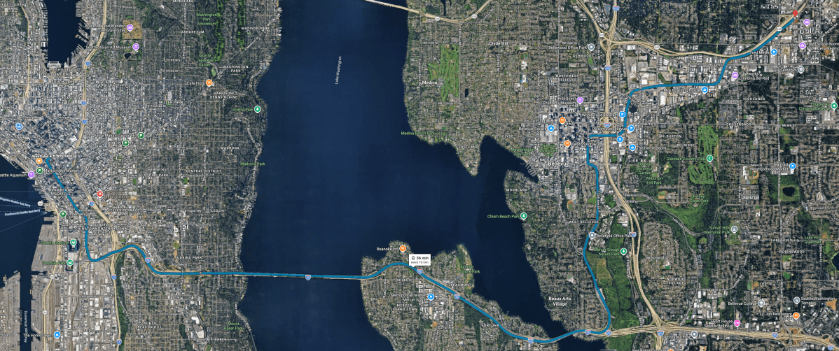
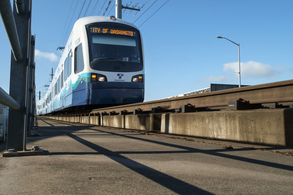
Connect it with transit. This is the part people skip. A third place you can only reach by car has already excluded the teenager, the person who can’t afford a car, and the elderly parent who shouldn’t be driving at night. Transit is what makes a third place actually a leveler instead of a leveler for people with a parking spot. The whole point is come-as-you-are, and “as you are” includes carless.
Let it be unprogrammed. The best ones aren’t curated. Nobody planned them into being with a “community activation strategy.” You build the conditions, the walkable block, the cheap seat, the transit stop, and then you get out of the way and let regulars make it theirs.
The Places That Could Actually Do This
The good news is that the template isn’t exotic. We already know the building types that become great third places when you put them somewhere walkable and let them breathe. It’s worth naming them, because the recovery plan is mostly “build more of these, in the right spots, reachable without a car.”
The public library and the branch reading room, first and always, because they’re free and they ask nothing of you. The community center and the parks-department rec center, with the drop-in gym and the meeting rooms nobody’s monetizing. The independent coffee shop that keeps the outlets in the walls and doesn’t glare at you for staying two hours. The neighborhood taproom or brewery, which has quietly become one of the most functional modern third places we’ve got: communal tables, kids welcome, dogs welcome, no bottle service, nobody rushing you out. The barbershop and the salon, two of the last genuinely conversational counters left. The board-game café and the record shop and the hobby store, where the point is the browsing and the regulars as much as the buying. The makerspace and the hackerspace, which is the tech world quietly reinventing the workshop-as-social-hub (and yes, my kind of place). The farmers market, which is a pop-up third place that reappears every week for free. The diner. The plaza. The laundromat, of all things, in the neighborhoods where it doubles as a living room. And the place of worship, still one of the strongest community anchors in the country for the people it serves.
None of these are new inventions. They’re the ordinary furniture of a functioning neighborhood. We just have to make it legal and convenient to have them nearby.
Don’t Sleep on the Parks
The most underrated third place in the Seattle metro is the park, and we happen to have world-class ones. A good park is the purest version of the concept: free at the door, open to everyone, no purchase required to sit down, and busy with strangers who slowly become familiar faces.
Green Lake is basically Seattle’s outdoor living room. The 2.8-mile loop is dense with walkers, runners, stroller convoys, and people just parked on a bench watching the whole city go by. On a sunny day it’s the closest thing we have to a genuine commons, and the community center and pool anchor it year-round.
Cal Anderson Park on Capitol Hill is the neighborhood’s front yard, and it’s the model for how this is supposed to work: dense housing all around it, a light rail station right there, and a mix of people that actually reflects the neighborhood. Walkable, transit-connected, and free. That’s the recipe.
Gas Works Park in Wallingford turns industrial bones into a gathering spot, with the kite hill and one of the best skyline views in the city. Volunteer Park gives you the conservatory, the museum, and big lawns for doing nothing productive. Discovery Park in Magnolia is more nature-retreat than social hub, but it’s a reminder that the region built room to breathe into the map.
There’s more where that came from. Seward Park wraps an old-growth forest around a Lake Washington peninsula, with a flat shoreline loop that pulls in the whole south end. Magnuson Park at Sand Point turns a former naval air station into sprawling waterfront lawns, sports fields, and off-leash trails. Golden Gardens in Ballard is where half the city goes for a beach fire and a sunset over the Sound. And Lincoln Park in West Seattle stacks Puget Sound shoreline, forest trail, and a saltwater pool into one of the best free afternoons in the city. Not one of them costs a dime to walk into, which is the whole point.
The Seattle Spots That Are Getting It Right
I’ll point at Seattle, because it’s what I know, and because a handful of neighborhoods here are quietly rebuilding the conditions on purpose.
Columbia City is the clearest working model in the city. A compact, landmark-protected business district on Rainier Ave, a light rail station a few blocks off, a farmers market that takes over Wednesdays in season, a bakery, a jazz room, a movie house, and a theater, all packed into a few walkable blocks. It’s dense, transit-connected, and mixed enough that people actually run into each other. That’s the recipe, executed.
Ballard does it the old-street way. Ballard Avenue is a genuinely pedestrian-scaled historic strip, the Sunday farmers market runs year-round and turns the whole avenue into a commons, and the brewery cluster a few blocks over has become one of the best modern third-place scenes going: communal tables, kids and dogs welcome, nobody rushing you out.
Pike Place Market is the ur-example, and we forget it because it reads as a tourist postcard now. Strip that away and it’s still what it was in 1907: a public market where the fishmongers, the farmers, the buskers, and the regulars all share one floor, free to walk, no purchase required to be there. It’s a third place absorbing millions of visitors a year and somehow still working as one.
Third Place Books is the one named for exactly this concept, and it earns it. The Ravenna and Seward Park stores anchor their neighborhoods, and the flagship commons just north of the city in Lake Forest Park wraps a stage, a pub, and food-court-style seating you can camp in all day without buying a thing. It’s the clearest proof that if you build the room and keep the door free, the regulars show up.
And across the lake, Crossroads in Bellevue still earns the shout: a 1980s mall that quietly became a genuinely public living room, with permanent chess tables, a stage, and a food court that runs the length of the actual immigrant Eastside. Proof the concept doesn’t belong to Seattle alone. Build the conditions anywhere and the place follows.
The Bottom Line
The third place didn’t die of natural causes. We killed it with zoning codes, parking minimums, rent structures, and a car in every driveway, and then we filled the hole with screens that mimic company without providing any.
Reversing it isn’t nostalgia and it isn’t a gadget. It’s boring, concrete, and entirely within our power: legalize the corner café, build the housing around it, keep the front door free, protect the park, and run the train that gets people there. Do that, and the regulars show up on their own. They always have.
The places come back when the conditions come back. So let’s rebuild the conditions.