Reviewing Seattle’s Neighborhoods, Madison Park Area

This is my first entry in what will be a series.  I’ve been searching throughout a number of neighborhoods to check out the ideal combinations of livability features.  The lease is coming up in about 5 months and I want to be prepared to get into a more ideal location.
Here are my measurements and data that I’ll provide with each of these reviews.
  • Walk Score: from at least 2 residential locations in the neighborhood:  Via http://www.walkscore.com/
  • Transit Options:  What buses traverse the area and what other town centers/areas are easily navigable via transit.
  • Night Life:  What time does the neighborhood generally “shut down”, or at least appear to.
  • Sleep Quality:  This is simply a combination of noise, crime, feeling safe, and other measures and feeling rolled into one.  Ranking will be Good or Bad.
  • Arterial Mapping:  This will be a map of the primary transit & road arterials in and out of the neighborhood.
  • The Unique Bits:  This is a list of things that make a particular neighborhood unique.  Think of it like a list that makes this neighborhood not like the ticky tacky, cookie cutter, suburban sprawl neighborhoods.
  • Architecture Mix:  See this chart for examples:  http://www.theplancollection.com/house-plan-styles/

Seattle’s Madison Park Area Review

Google Images with the search Madison Park, Seattle, WA.

Bing Images with the search Madison Park, Seattle, WA.

The first neighborhood that I’m covering here is Madison Park Area Neighborhood.  This is a rather upscale, somewhat rich neighborhood that has great views of Lake Washington along the north and eastern edges and meshes up against the Madrona Park and Montlake Neighborhoods to the west and south.  The neighborhood has hundreds of beautiful homes, condos of many architectural styles such as Cape Cod, Coastal, Colonial, Contemporary, Modernistic, European, Feng Shui, California, Row Houses, and other architectural styles.  Barely a bad home among the lot, which is really impressive for any neighborhood of this size.

Architectural Mix:  Cape Cod, Coastal, Colonial, Contemporary, Modernistic, European, Feng Shui, California, Row Houses, and other architectural styles.

There are two primary arterials coming into and out of the area.  This can be a huge negative or positive.

The Unique Bits:  This neighborhood has some great unique elements.  At the end of Madison Avenue is a strip of little shops, bars, and other things right across from a gorgeous park.  In addition to this the views of Lake Washington are absolutely tranquil.  Nothing in this neighborhood is outrageously unique, but a calm, conservative, collected uniqueness about the neighborhood does exist.

Arterial Mapping:  2 Streets, East Madison Street & McGilvra Boulevard.  The area is surrounded on the western, northern, and eastern edges by a park, a waterway, and a beautiful lake limiting the arterial route options.

First there is East Madison Street that leads into and out of the area to downtown Seattle.  This route is mixed traffic, primarily cars and small delivery type trucks.  It is also the primary transit route in and out of the area.

The second primary route south, along the lake is McGilvra Boulevard East that then merges onto Lake Washington Boulevard East.  This route is absolutely beautiful riding along Lake Washington.

Neither of these roads however connect to any major infrastructure, highways, Interstates, or other arterials.  They’re also both slow moving routes, with maximum speeds around 20-30 mph.  For residential lifestyles this is perfect, if you have a commute to outlying areas of the city this is going to add 15-35 minutes to whatever commute one already has.  If you’re going downtown though the bus provides a direct and easy route down Madison Street.  If one works at Boeing, Microsoft, or an outlying area though they should do themselves and the neighborhood a service and not move here.  Otherwise you’ll be driving all the time, cluttering up the roads & causing congestion, etc.  If you absolutely love it though, I suppose those are just the trade offs.
Sleep Quality:  Crime is low (almost non-existent), the area is very quiet, and sleep is easily to attain.  The architectures of most buildings are solid, enabling quiet buildings even in stormy or wind whipping weather.
Night Life:  Night life in the area doesn’t exist.  There are no theaters, late night bars, or music venues nearby.  If you like quiet neighborhoods with minimal activity after 6-7pm this is a good area.  If you want to enjoy art, music, movies, or anything of that sort one would have to leave the area regularly.
Transit Options:  For commuting to downtown areas, this is not a bad place.  For getting to anywhere else in the city, or for after work hours transit usage this area doesn’t have except one option.  Which for those car-free lifestyles really limits one.
Walk Score:  This neighborhood received an 83 – Very Walkable.  Check out walk score for Madison Park for more information on the walk score, check out various commute measurements, and other information.  Overall Madison Park Area ranks 28th in walkable areas in Seattle.
Just for travelling context, the way I traveled into and out of this neighborhood was on these routes, via a zipcar.
Inbound Route:
Outbound Route:

Another Way Home

I set out on a very round about alternate route home today.  Events and scheduling of the day had lined up perfectly for such an alternate trip.

My normal trip home from Redmond, Washington is to board the #545 at Overlake Transit Center bound west for Seattle proper, once there I just walk about towards home, sometimes from the downtown core or sometimes down Denny or through South Lake Union.

Today I’m heading south from Overlake Transit Center on the #566 headed for Auburn, Washington.  The bus takes a trip south down through Bellevue, then on down I-405 toward Kent.  From either Kent, or a stop before then, I intend to transfer and hopefully catch a north bound Sounder Train.  Since this is a rather spontaneous effort, I could be stranded at any random location.  However, I’ve no fear, so “meh” I say.

I ended up realizing I wasn’t going to make the Sounder, so decided to get off at the Renton Transit Center in downtown Renton.  It seemed I had good timing as I got off the bus and walked right into the Renton Farmer’s Market!  Kettle corn was smelling great, freshly cooked up, and all sorts of tents offering various things.  I love these bits of community, absolutely great!

I however skipped out on the farmers market and went into a local establishment called Best Burger.  It was located directly across the street from the transit center.  Further along 3rd the Italian Joint almost caught me, but I wanted something along the junk food line of American Burger.

Route #106

Afterwards I scoped out a return trip to Seattle proper.  I ended up with deciding on the Metro #106 Route.  It has a winding route from Renton, by Rainer Beach a ways, and up and over Beacon Hill.  Unfortunately it doesn’t pass by the actual Beach, I’m still curious to see the area.

The bus wound up over steep hills, twisting and turning through the streets.  We left Renton without much to notice we did and onward toward Rainier Beach Area.  The skyline was beautiful, with trees reaching up broke the spears of sunlight.  Each ray of light flashing as the trees gave relief to those sitting by the windows of the bus.  However several people still shielded their eyes from the brightness.

Once the bus made it to the top of the hill, one could look back and see off into the distance as we turned.  The bus stops seemed like they were every block or two now.  If you’ve checked out the link for the #106 route, you’ll see that there are a great number of stops along this route.  This is one of the reasons that I chose it, as I knew the run would be a bit slower, making it easier to take in the view of the route.

Moving along the spine of the hills we entered Skyway.  Once on this rode I knew I had picked a gem of a route.  This part of town was pretty sketchy.  Businesses along the way were open, but just as many were shuddered.  Some of the single level buildings, and some two story buildings weren’t shuddered, but could easily have been mistaken for being so.

We rolled further along the route through residential and commercial districts.  Along the decline of Skyway I looked out and could see the southern stretches of Lake Washington.  Highway 90 was in the distance, with cars the size of ants zipping across.  The water looked smooth glimmering in the sunlight.  The tree lined shores of the island broke the water with vertical ease.  With the sun and blue  skies this was a rare sight for this area I’m sure!

A little further along the route intersected with the Link Light Rail at the Rainier Beach Stop.  From this intersection the route zigzagged back uphill.  Some of the views down on Lake Washington are awesome from up here on this route.  At this point, I’m glad I decided on this one!

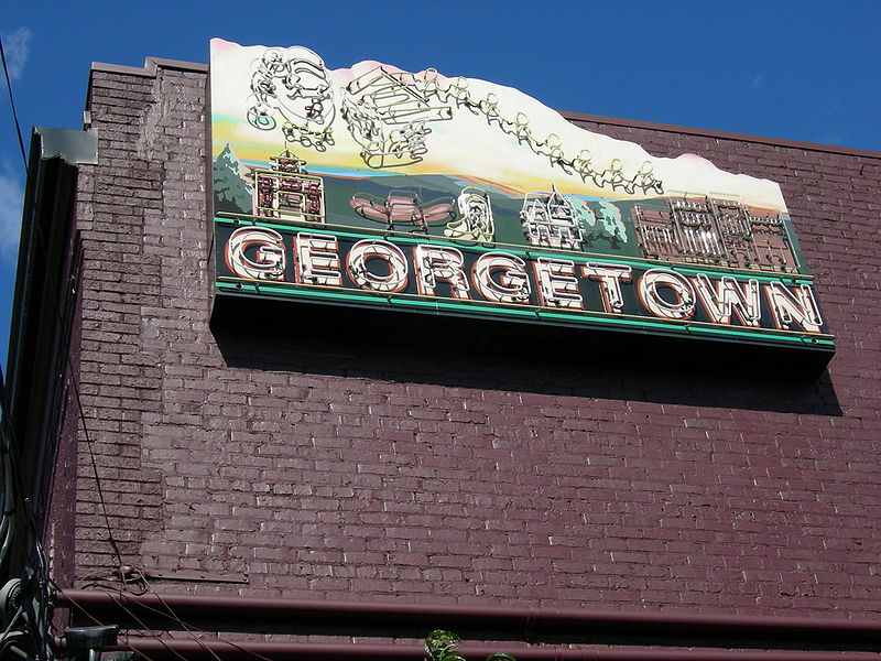
Georgetown!

After a bit further a plane came SCREAMING overhead!  I bound across the bus to see where it was in bound for.  Sure enough we were by the Boeing Airfield south of downtown Seattle.  We pulled up at the first stop in Georgetown and I saw a cool music shop and next to it a coffee shop.  I then commenced to walk along the street in Georgetown and be wowed and the coolness of the area.  Absolutely loud, being sandwiched between an air field, the Interstate, multiple rail lines, and other industrial nitty gritty, but awesome atmosphere for rock n’ roll, biker bars, and the like.  Very rock star is what I’m saying.

I walked around for about 45 minutes and then headed onwards toward downtown.  That was my commute home for today, slightly different than the norm.  :)  Cheers!

A Smack In the Face

Today I decided on a bit of a round about way to get to work.  First a view of my commute (this is for the local office, not my Redmond Commute).

Instead of just heading along on the walk shown above (or one of the multitudes of routes (358, 5, 26, 28, or even the 30, 17, or otherwise with a little bit of a walk before) I went for the following trip.

First I boarded (at Dexter and Denny) the King County Metro #8 (Click the #8 to see the route map) headed east and went to Capital Hill for a coffee at Stumptown.  It had been a while since I had one of their brews so I felt it was a good Friday idea.  I got off the bus at Broadway and headed toward the Stumptown at 616 East Pine Street.  Saw a few buses roll by heading into Seattle proper packed to the rim with people.  The #8 route is shown below.

I enjoyed a capacino and once I finished a bit of blogging and reflection I walked down a block and boarded the #11 heading into town.  A short ride and I then walked over and boarded the #17 out to 1515 Westlake for the end of my morning journey.

A round about way to get to work, but fun in the end.  It’s always nice to get a little bit of a different view of the city and all the morning flows of people to and from.  For the evening commute, I may walk, may bus, or maybe zig zag across the city street, I’ve no idea yet.  With that, I’m off.

I Felt Spontaneous

Because of that, I got off the bus at Montlake Expressway Stop instead of getting all the way into the city on #545.  I didn’t know where I was, but figured “what the hell, I’ve got 2+ hours before I have to be somewhere.”

I got off and walked up the sidewalk to the main street.  The bus pulls off a side stop, called and Expressway Transit Stop or something, and people can get on or off the stops and walk up to the primary surface streets.  I got to the top and immediately saw about 50 bikes (ok, I didn’t count but there were a lot of them).

I walked across the overpass and to the south bound (toward downtown Seattle) and boarded the next bus that came along.  The #48 pulled up and I flicked my newly received Microsoft ORCA Card and off we went. 

After just a few minutes I got off again, not being sure where the #48 actually went, to check were and what route I needed to be on.  The #43, which I knew goes downtown, runs parallel to the #48 route along this road.  I could at least board it.  However I saw a Fuel Coffee Shop a second ago and decided to walk back to it.

I arrived and purchased an ice coffee.  I pulled the laptop out to figure out where I was, and where I needed to go to arrive at Fado in downtown Seattle by 6pm.  I first looked up Fado to be sure of the address ”801 1st Avenue, Seattle, WA 98104-1404”.  That looked good so then I looked up what routes I was near to figure out where I was actually at.  I found myself near E Lynn St and 24th on OneBusAway.  So now I went back to Google Maps and threw in the two address I knew of “801 1st Avenue, Seattle, WA 98104-1404” to “24th Ave E & E McGraw St”.

This is where I didn’t like the results.  Google Maps told me to go back to the Montlake Expressway stop and get on something from there to go downtown.  I didn’t want to do that so I figured I’d board the next #43 and just enjoy the scenery.  So with that I finished this entry up and…  vroom, off I went.

Walk, Ride, Around About Seattle, A Bit of Caffé Vita and Fremont

The Blur of Saturday Morning

It is Saturday.  I am feeling a bit retrospective.  New city, new residence, new places out there.  I decide I need to get out and about, otherwise I am going to get to feeling kind of ratty today.  Nothing like wandering to clear the mind, get one’s ideas straight, and get the motivation kicking again.

I got up around 8am, maybe later, not really sure.  I put myself together and out the door I went.  No coffee, no food, nothing but a laptop, cell phone, ORCA Card, and some wanderlust.

First I decided that coffee was in order, so I headed toward the Uptown Espresso at 4th and Wall.  However, just after crossing Denny by the Monorail, here comes a #8 (#8 route map) which just seems like the perfect route to kick off my day with.  So with a flicker of thought, and pondering if I’ll survive without coffee, I decide to board the bus.

We get to rolling and pass across I-5 and slowly make it up the hills toward Capitol Hill.  At John St & 15th I note a Safeway, which is important for the car free life.  In these parts the Safeways are often the cheap bulk stores that are great for commodity type goods.  Unlike the Whole Foods, which are great, but suck up every penny a poor soul has to their name.

The #8 route continues up and over the hills into residential streets.  Beautiful neighborhoods that remind me of north west neighborhoods.  The green is lush, the hills steep, and people walking about carrying on with their daily lives.

At Madison and MLK Streets there is a small slice of stores mixed into the middle of the neighborhood.  The bus just pokes along this section with us 4 riders.  Unlike other times I am not particularly observant today.  I haven’t noticed the people or been watching them.

I pull up another map, to see where my connection points are to get back into town.  The Sound Transit Link Light Rail has several connection points that look perfect.  I figure if anything, being deprived of coffee still, it ay be a good idea to grab the light rail back into town and and get a cup of coffee that I’d trust.

I finally transferred at the Othella Link Light Rail Station stop.  The #8 headed off on its southward route, and I walked around the station area.  The area was somewhat sketchy, nothing compared to my New Orleans days of wandering, but sketchy for the north west.  As always, this didn’t really both me and I walked about looking in the unopened stores.  At this time of the day, this part of town is shuttered.  I’m betting though if one wants some Pho or other Vietnamese treats, this is probably a good part of town for that.

Flanged Wheels Rolling and STOP

So I boarded the light rail train that came along next.  We zipped off quickly heading north into town.  I got a little curious about the tunnel station under Beacon Hill.  That curiosity kicked me into gear and I decided to go explore that area too.  I got off and headed up in the elevator to ground level.  I got out and this part of town was rather desolate.  I must admit, I’m not sure why Sound Transit or Seattle or whoever, decided to stick this station right here.  There is literally nothing that is particularly walkable from here.  Maybe it was hiding, but it definitely was not visible.

I walked a few blocks toward where I could see over the edge of Beacon Hill down upon the city.  Even though there wasn’t any immediately walkable coffee shops or such the view up here is spectacular.  I needed a panoramic camera to get this shot of the city!  One can see the shipping loaders, the SODO area, and of course downtown rising from the Earth.  Absolutely great view.  I’ll have to return here just for pictures upon getting a camera to do it justice.

I then headed back into the tunnel, boarded the next train, and zipped off toward the city again.  I love coming out of the tunnel on the raise section of rail overlooking SODO.  Being able to see the light rail facilities and passing along the bus facilities is interesting for a transit sleuth like me.  We rolled into SODO and then onward.  However at some point we came to a complete stop!  We just sat and sat there.  The recorded voice came on the speaker and said there is traffic and we’ll move forward in just a moment.

That left me with the thought, if the voice is recorded to say that, how often do they have delays on the light rail because of traffic?!?!!?  This is a dedicated, controlled, unimpeded right of way!  WTF!  Nonsense, again, if I ran transit this nonsense would be a thing of the past (at least with five 9s of no delays).  Anyway, not like I was unhappy, just kind of shocked at the ridiculousness of the situation.

Then after a few minutes the driver came onto the speaker as we sat, “There is a bus broken down in front of us so as soon as they get it moved we’ll pull into the station.”  Oh my god the perverse transit related irony of this situation!  A BUS is blocking the dedicated LIGHT RAIL.  I suppose though, this is the one part that isn’t dedicated.  This points out two issues – 1.  Buses break down (for whatever reason) a LOT.  2.  Rail based vehicles can’t pass things when appropriate infrastructure isn’t available (like passing tracks).

After the 13-15 minutes STOP we experienced we finally pulled forward.

Caffé Vita Mmmmm

I got off the light rail at this stop and walked over to Caffé Vita at 125 Prefontaine Place South Seattle, WA 98104-2672.  I knew this coffee shop from many previous visits to Seattle.  They make a high quality cappuccino which is much needed sometimes, especially on a day like this.

http://maps.google.com/maps?f=q&source=s_q&hl=en&geocode=&q=caffe+vita&sll=47.619718,-122.34587&sspn=0.008996,0.014699&ie=UTF8&hq=caffe+vita&hnear=&ll=47.601215,-122.329337&spn=0.008999,0.014699&z=14&iwloc=A&cid=8054863590227938189&output=embed
View Larger Map


Finally I headed out from Caffé Vita and north bound to Fremont via the #28 (#28 route map).  This route is initially the #23 (#23 route map) before it turns into the #28 I found.  This is a good thing to know, being that I didn’t, but d
ecided at the last minute I’d board the #23 to get further into town.  Once I got into town I got off, thinking that the #28 was coming and fortunately looked back at the bus and realized it now read #28.

This is by far another stupid point for Metro.  How the hell is anyone supposed to know the route change if all they’ve looked at is the time points or the numbers on the stop?  The stop had #28 listed, but #23 comes up to the stop?  That’s not good at all, that just introduces total confusion for riders.  But alas, I managed to get onto the correct route.

Awesome Hippy Land Communist Capitalist Fremont

Just toward the center of Fremont is an actual X-Soviet Statue of Lenin.  Yes, that guy that managed to create one of the most horrific Governments in all history.  Yeah, that dude!  His statue is on American soil standing in Fremont.  I found this hilarious and sad.  But wait, that isn’t the entirety of the sadness.  The reason it is here is because of an American individual who saw the statue toppled and desecrated in the then X-Soviet Union after the wall came down.  He re-mortgaged his house to get the status – which weighs tons – back into this country.  Nothing against the guy for liking art, but wow, that seems like a lot of trouble for a part of history that is of questionable perpetuation at best.  Anyway there is this statue, of him in front of arms (i.e. armaments of war) and flames moving into revolution as he did.  In an artistic sense this is awesome, in a tasteful sense it is of questionable nature to keep a statue that for millions represents great suffering and death.  But I digress, it really isn’t for me to say as I stood against and have always stood against what Lenin did.

I wondered about and found Tableau (a company I have worked with and almost prospectively worked for), and Adobe Office, and a bunch of other things in the Fremont area.  This is one of the cooler places in Seattle.  I got off the bus and wondered a good hour plus in this area of town.  There are coffee shops, diners, breakfast places, and much more.  I also found a great sandwich shop.
After wandering about for a time I went back and boarded the #26 (#26 route map) back into Belltown.  I retraced this route later, but as for the exploratory wandering this was it for me today.  Great fun, awesome discoveries, and more to come in the near future.  Enjoy.