A Beautiful Ride into Portland and Tactical Urbanism Surprises

Today I rode into Portland as I’ve done thousands of times. Today I cycled across the Skirdmore Bridge over I-5, across Mississippi Street area and over to the Vancouver/Williams bike routes. As usual, at the hour I was riding into town there’s a decreasing number of people from the rush hour commute. A few cars, and 2x to 3x as many cyclists plying their way down Vancouver. I passed the New Seasons, made the red light and on through the hospital area onto the part of the route that is a gradual downhill for the next mile or so.

I cut over at Russel Street to the easier to navigate Flint Avenue. I rolled by the Ex Novo Brewery and looked over as a few people dropped of kids at the Harriet Tubman Middle School. I rolled around the parents as they attentively watched myself and other cyclists pass in the through area of the road. I always worry around schools since there are so many parents who tend to become distracted and run over their children, or in some cases pedestrians or cyclists trying to just go by.

As I rolled onward, still on the downhill segment of the ride I came to the mess of construction that has the Broadway Bridge closed to almost every mode (at some point or another it has been at least). Today it was closed to automobiles, streetcars, and any motorized transport, but one side was open for pedestrians and cyclists. So I entered the bridge and began the uphill climb to the west side of the bridge for the Broadway drop into downtown.

Since oncoming traffic lanes were closed to the bridge I went ahead and just veered to the left and cut over at Irving Street. I got a good view of the train station, looking majestic this morning with the wonderful blue sky for the backdrop. I zig-zagged over to Hoyt and then onto 3rd.

On 3rd the bike lane begins at Glisan and now continues all the way to Burnside, which is excellent to have a clear route like that. I continued toward Burnside, and as I came to the street the light turned green and I noticed orange traffic cones on either side of the bike lane. It looked a little odd, but as I rolled further I realized that they were labeled with PDX-trans-formation, which from Twitter I know is @PBOTrans. I rode through and had to stop though, because I wanted some pictures! This was the first time I’d actually found some of the tactical urbanism of @PBOTrans.

After I snapped my pictures I continued on, got some work done, finished several errands, and headed over to a coffee shop to wrap up some more work before the meetup tonight. While there I pulled up twitter to check out the account and lo and behold it seems that there were already a whole bunch of tweets and other people noticing them too! Here’s a few choice tweets below.

Fixing Greenways (or Bike Boulevards?)

Ok, so it seems the names change, so I will kick off this blog entry with a definition of what a greenway is.

Neighborhood Greenways are residential streets with low volumes of auto traffic and low speeds where bicycles and pedestrians are given priority.

Here is some more information on the Multnomah County Site. I’ve posted a screenshot of the map on that page below.
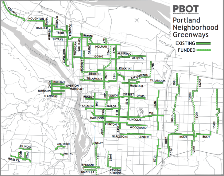
2016-03-12_17-05-24

There’s also a useful video, produced a good while ago, that explains when the bike boulevards became neighborhood greenways.

The goals of these greenways are simple: (PBOT description on the left, my translation on the right)

  • Reduce auto cut-throughReduce dangerous cut-through behavior unfamiliar with neighborhoods endangering people in those neighborhoods.
  • Safer cycling and pedestrian connectionsInsure motorists don’t kill more pedestrians, cyclists, and those in their homes (not joking, motorists keep running into stationary builds with people inside), and generally create safer ways to get where we all are trying to go.
  • Reduce auto speedsbecause seriously, slow down on neighborhood streets asshole. Whoops, that was a little aggressive, you get the point.
  • Help people cross busier more dangerous streets – Where streets are designed where motorists have killed people, improve the intersections and crossings to prevent motorists from killing more people.
  • Provide easier guides on the routeMake it easier to figure out where you’re going, even when you haven’t checked your google maps route.  😉
  • Provide more “eyes on the street”I think this means more people biking and walking means safer streets, as the data proves, as motorists tend to chill out when lots of people are out and about keeping an eye on their bad behavior. Or it just means more people are staring at the street. I’m not 100% sure about this one.

Ok, so now we have a shared understanding of what a greenway is and generally where they are in the Portland city limits.

But where are we now? There are problems…

A few events have taken place in Portland that have led to some pretty serious problems on the greenways that need to be resolved sooner rather than later.

First Event: There have been thousands upon thousands of new residents that have moved to Portland. Hello to all of you that have moved here over the last decade, welcome to the city! That’s all fine and dandy, this has had profound changes on the city – for better or worse – and the one big change I’d like to point out is that this influx of people have led to more people on the streets. It isn’t just cars, but all modes, however the mode taking up the most street space by orders of magnitude that moves less people are — drum roll please — cars, you guessed it. Because of this there is increased traffic. This leads to more people trying to take shortcuts. Taking shortcuts leads me to the next big event…

Second Event: This app called Waze happened. It’s great for the motorist stuck in traffic, but it enables the stuck like a pig in a cage driver to use the road system in a way it WAS NOT PLANNED TO BE USED. A motorist is NOT supposed to be cutting through neighborhoods (at 20mph or 50mph for that matter) to get from one highway or major arterial to another. But this app enables exactly that. It’s made once pleasant and low traffic neighborhood streets (i.e. greenways and such) into traffic sewer bypasses and cut throughs.

Third Event: The economy improved, yay! Good for us, good for you, good all around. It’s a good thing when the economy is enabling us to feed, eat and clothe ourselves along with enjoying life! However there is a dark side to this, because about 49% of trips into downtown Portland are not made by biking, walking, or transit, but by a single person in a single car, which creates a maddening and dangerous rush hour. Every single day the pollution skyrockets and the air quality decreases dramatically because so many people want to drive, drive, drive. So they do, and hey, we’re America land of freedom and stuff so we subsidize the hell out of that and enable as many people as possible to drive… but, a lot of these now employed people are out there driving, using things like Waze, moving here for work, and generally being a motorist sucking up a bunch of space in their private car and dirtying up the air in spite of the other 51% of trips into and out of downtown that are not done in such a selfish way.

So that is the root of our big issues. But now, how do we fix such issues? It’s actually super easy!

Solution #1: Diverters

Physical diverters direct auto traffic out of neighborhoods onto primary arterials where higher speeds and higher throughput of automobiles is possible. Instead of buzzing through neighborhoods for long trips automobiles are sent into the key automobile sewers like Highway 99 (MLK), Highway 26 (Powell), I-5, I-84, I-205 and other main drags like Hawthorne, Cesar Chavez, Rosa Parks, and others.

These diverters do this and make neighborhoods better for those that live in the neighborhood. Diverters make the neighborhood safer for the children, the elderly, and all the rest of us just walking along the sidewalks, biking down the street, crossing to the local neighborhood coffee shop, or otherwise.

Implementing these is the key, there are some, but we’re in desperate need of many more. So many greenways have no diversion and easily fall prey to Waze and turning into a car sewer. Recently my wife and I stopped biking toward our destination and returned home because of the incessant motorists passing (most safely, but some unsafely with unclear motive or going straight, turning, or whatever they’re doing). Many of the motorists were clearly confused about where they were going, how to return to the Interstate (Avenue or I-5) and were overall, clearly perturbed that they’d taken a cut through and ended up getting stuck and routed back toward the road they were already on – stuck in rush hour traffic.

I learned two things, one is that rush hour is not a good time to ride to a location for dinner or drinks unless you’re a confident and fast rider (then you’re just always ahead of the motorists anyway) and two, the bicycle infrastructure leaves cyclists in a position prone to aggressive motorists and motorists are in a position that they’ve put themselves in – in traffic stuck. So in the future, I’d love to see some diverters to keep those aggressive, confused, and perturbed commuting motorists out of the neighborhoods. In the end, it’ll help the motorists and everybody in the neighborhood.


Solution #2: Bikeways, Cycle-tracks (Euro style), and the like need expanded dramatically.

The west side is perfect and can easily take on cycle-tracks and bike ways. But so can downtown Portland and the inner east side (re: river to about 20th should be easy to implement). So far though we’ve fallen short of what we can accomplish. To insure that the greenways can appropriately feed the city and people can bike to and from safely, the greenways need connected by cycle tracks and bikeways. Without we will not be able to go much beyond what we have now. The 8 year olds to the 80 year olds won’t bike. Regardless of the stats, it is simply to scary on the roadways for the somewhat less confident riders.

To summarize, adding real cycle-tracks and bikeways to the major hubs we bike to, would enable the greenways to truly thrive. The planners know it, the stoned guy on the corner knows it, anybody that connects any kind of simple thoughts knows it! The question is, will we act on it as a city and get diverters put in place and get some real greenway connections into and out of the city core. The possibilities are numerous, the only action left is to implement.

Where Does The Money Come From?

I’ve mentioned in the past that cities should think of things from more of a systemic mindset. Currently however that’s almost completely impossible considering how funding and Government is organized in the United States. Even within groups things are pitted against each other that shouldn’t be. Let’s take a look at some.

For Oregon the main transportation organizations that handle budgets, building, and planning are ODOT and Trimet. You might thing, oh, but Trimet is Portland’s transit system. Well, this is true and false. It’s actually headed up by a board and the Governor who mandates much of how they operate. It also is responsible for transit over a three county area: Multnomah, Clackamas, and Washington. Portland, actually has little control over anything Trimet does besides some tactical issues around capital project design and maybe funding some of the service. Most of the service falls on the back of income taxpayers. Actually about 78% falls on the backs of the income tax and those who pay it. Only about 22% of operations comes from fares. The remaining bulk of capital projects, which is as much or more than operational costs, rests primarily on state budgets, federal injections of cash, and incurred debt on the back of tomorrows taxpayers (i.e. bonds/loans and related funding structures). Here are some of Trimet’s budget documents.

ODOT is funded out of the gas tax and other miscellaneous funds. The bulk of their money going to road construction and encouraging auto-dependency. Some minor funds go to freight, passenger rail, and related matters. Keep in mind, ODOTs bucket for auto related things is the vast majority of their budget. Here are some quick links to ODOT budget information.

Let’s not forget the feds. The Federal Government provides a large influx of transportation infrastructure spending. Also, they spend the largest amount on auto-related transportation infrastructure and auto-dependency programs (i.e. subsidies for parking, funds for roads, etc) The Federal Government also gets a large chunk, but not all of their money from the federal gas tax. Here are some of the documents if you want to educate yourself on the Federal Budgets and funding from the FHA (Federal Highway Administration).

The other parts of Oregon’s transportation, since almost half the population of the state lives in the Portland metro area, is PBOT, or the Portland Bureau of Transportation. Here are some of the budget documents of their’s.

Transit Projects: Faux BRT – A Summary of the Situation

Previously written about here.

There are two projects that are either being built or are in the works. There’s the Trimet Powell & Division Corridor BRT Project and north of Portland in Vancouver there is the Fourth Plain “The Vine” BRT Project that is being built right now.

What is BRT? BRT, or Bus Rapid Transit, is bus service over dedicated lanes. This service is generally provided with higher capacity buses that are 60 feet long or longer. Think of current light rail service in downtown Portland it’s basically similar to that, just with buses. The buses run in these dedicated lanes, people pay fare off of the buses at the stations, they have light precedence, and that way the buses are able to move along much quicker than traditional bus service.

The two “BRT” projects I mention above are neither BRT nor regular bus service, but instead a mix of traditional bus service and BRT. The bus service for The Vine and Trimet’s current project will include 60 foot long buses, payment at the stations, but beyond that will have no real features that would make BRT. Thus the reason I labeled the service “Faux BRT”.

Bus Service Improvements : The Current Situation

Even though these lines won’t be real BRT, the good thing is that both of the lines are pretty dramatic improvements over what currently exists. Right now both routes have regular, frequent stop, local bus service style operation. That means they stop about every other block, which makes them timely or efficient if you need to only go a short, very short distance. Otherwise they quickly double, triple, or quadruple the time it takes to simply bike or driver the same distance.

In the case of The Vine in Vancouver, the route will travel along Fourth Plain from downtown Vancouver to Westfield Mall. The route currently has two routes that serve the bulk of the corridor: the Ctran #4 & #44 routes. The #44 is an express bus that currently travels from Delta Park in Portland (the second to last stop of the MAX Yellow Line) and goes to Westfield Mall and past it onward to some other key points. The #4 goes from Delta Park, the same MAX stop, through downtown Vancouver, and onward along Fourth Plain until it reaches the Westfield Mall.

In the case of the Powell/Division Corridor, there are two buses that run this primary corridor right now too: the Trimet #4 & #9 routes. The #4 actually starts far north of Portland in St Johns, travels all the way south into downtown Portland, then back across the Hawthorne Bridge, then over to Division and onward until Gresham. Almost 15 miles form downtown Portland to Gresham, and the #9 completes a similar route, except on Powell.

The Ctran #4 and #44 are low ridership lines compared to the #4 and #9 in Portland. Which will make the ridership of The Vine interesting. Ctran intends to remove or significantly alter or curtail #4 and #44 service when The Vine starts running. The Trimet #4 and #9 lines are actually high ridership lines. Trimet doesn’t intend to entirely cancel either of these lines, but the intent that the ridership that currently uses the #4 and #9 routes in this corridor will likely switch to the new service to get downtown.

Predictions

In both cases the new service will reduce the overall costs for Ctran and Trimet to carry passengers in the corridor while making way for decreased trip time and a potential ability to carry far more passengers than can currently be carried with existing service. The current estimates, from yours truly Transit Sleuth, is that The Vine will like get about 8-10k rider trips per day. The Powell/Division Corridor Service will likely see upwards of 15k passenger trips or more per day and likely climb well past that once it has been operating for several months and people get used to the frequency and faster travel times.

A Major Concern for “The Vine”

There is one other caveat of The Vine, which might be a major sticking point. This bus service improvement actually curtails service in downtown Vancouver, while replacing the #4 and #44 bus. The #4 and #44 bus currently goes to Delta Park, which is one of the top destinations for all of Ctran ridership. The Vine cuts out Delta Park, which could cause a significant time increase and prospectively drop that 8-10k riders a day down significantly. I personally would suggest that Ctran and Trimet both need to figure out how to insure that the riders can get to Delta Park with one trip – one more transfer is unacceptable. Already the vast majority of riders on the #4 and #44 are going to Delta Park specifically for a transfer to the MAX Yellow Line, so adding another transfer would make an already time consuming & rough trip into a relatively unbearable one for the majority of riders.

So that’s my quick review of the situation. More to come on this topic later.

This is Not Rocket Science, It’s How to Get Around!

Recently I realized, we’re doing this wrong in America. It isn’t that we aren’t trying, and not that we’re building too much auto roadway, nor that we’re building bikes lanes or that we can’t get dedicated right of way for bicycles, nor that we’re building the wrong types of transit routes or using the wrong types of buses or too much light rail. We’re building, using, and expanding transportation in a horrible and haphazard way, this is clear, and this is the root of the problem.

Why The Dutch Have Superior Infrastructure

Spend a measly 6+ minutes to watch this video on how the Dutch got their cycling infrastructure. You’ll see many things we’re doing wrong, but…

You’ll notice the Dutch made the same horrifying mistake that we have in the United States in our cities. Starting at minute 1 in the video, they built solely for cars! Cars everywhere, they were rich, it would fix everything it seemed. Just tear down some old buildings and history and the life of the city, that’s all you need to do, is destroy a bunch of things for the cars to fit! (minute 1:20 in the video).

But then, the Dutch, unlike so many other supposedly civilized countries, called the slaughter of innocents what it was.

Stop Kindermoord!

The Dutch realized it for the endless murder and violence that it brings. The pollutions, sickness, and economic and environmental pain. The delays and excessive trips that one must take from sprawling out to build around the automobile and creating an auto-dependent culture.

But we’re still missing what actually gives them better infrastructure. Because it isn’t just that their bicycling infrastructure is great. They also have exceptional transit options and, it might be shocking, but many Dutch still drive. But they all have one thing in common that many Americans can’t understand – barely any of them sit in auto-traffic congestion everyday and barely any of them have a commute more than 24-26 minutes each way to work.

How many Americans spend about 20 minutes just sitting in stop and go traffic? I’m not sure of the exact numbers, but suffice it to say there are a lot.

The Dutch spend their commutes on trains, trams, and bicycles for the most part. A few Dutch actually drive a little ways to their work, rarely needing to stop at stop signs or four way stops. Largely because the Dutch don’t have many of these things and instead have fully operational and functional roundabouts.

But go beyond the Dutch. Most of Europe, at least Western Europe, understands and is working toward these types of options. They’re ridding themselves of auto-congestion and just removing the automobile from their inner cities.

But how are they doing that? Did they just realize that cars cause an unnecessary and uncomfortable strain on society as a whole? Well, some realization of that has helped. But that isn’t it. Is it that they are somehow magically superior in transportation intellect than Americans? Jokingly one might say yes. But that isn’t particularly it either.

The Axiom of a Solution

The solution is hiding in how these European countries (and even some places in the United States) organize their transportation. They build it in a systemic and complete way, not for one single mode. Starting from this vantage point, and realizing that roads are public spaces that all people can, should, and will use is key. Transportation organization, planning, operation, and the future of it must be centered around building a complete system around a full systemic thinking mindset.

We must build for all modes and prioritize accordingly. It really is the only way we’ll fix the eternal congestion people face, get people into and out of the places they need to be in a reasonable way, and above all it is the only way to really gain an increasing livability and standard of life in this country.

Solution: Systemic, All Inclusive, Structured Transportation Planning

Whatever fancy pants word someone wants to come up with for that, it doesn’t matter, it just needs implemented across the board and this haphazard – “build a thing for cars only” then “build a sidewalk here” and then “build a bikeway over here” and who knows where the hell it is all connected – nonsense must end if we’re to move forward!

I’ve got a lot more coming on this topic, including how to increase the throughput of automobiles – somewhat ironically – to how to make the transit system work better with minor funding changes or increases. Cheers to 2016 Portland, let’s start kicking some ass and really make this city work!