Ever since I moved to Seattle some years back, I’ve ridden all over the city pretty much all the time, any weather, by bike. But even amidst all this riding combined with tons of requisite hill climbing, I do enjoy cheating a hill climb every now and again. These are some of the ways I do this, and a giant thanks to KC Metro and Sound Transit for providing solid, reliable, and kick ass services to be able to pull off these hill cheats!
Capitol & First Hill Cheats
The easiest ways when riding to get up to the top of Capitol or First Hill, or mostly to the top of Capitol or First Hill, is to use the LINK, and secondarily the Capitol Hill Streetcar (which is by no means fast, but it’s real easy). The reason I bring up these two modes as the easiest, is because you can just roll on and roll off with a bike. No need to rack anything or go to any trouble, just on and off, with an ORCA swipe off of the vehicle. Let’s take a further look at the map of these two options, but first we should look at where the tops of Capitol/First Hills are here.
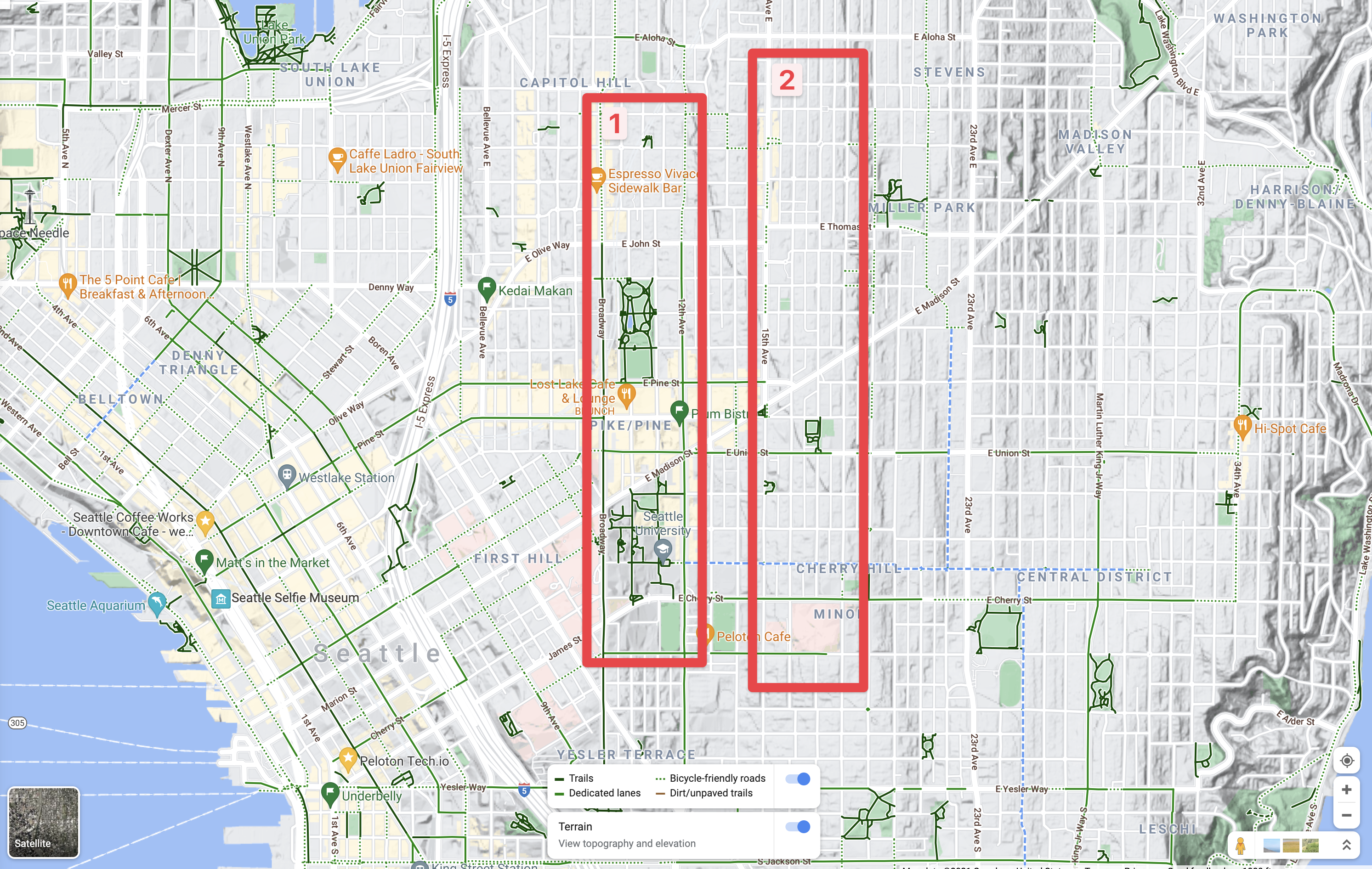
On this map above there are the two red rectangles, 1 is of the first and largely most populace and business heavy area of Capital Hill and First Hill. The 2 rectangle is of the higher, and has less business and more residential part of Capital and First Hills. Both areas have things anyone in Seattle will generally want to swing by on a semi-frequent basis if they’re into food, art, music, parks, or what not. It is, after all, pretty much the heart of downtown here. To the right of the 2 rectangle leads to Central District, Madison Valley, which is a huge drop from the hill tops. The other directions, such as westward into downtown Seattle are both huge drops from areas 1 and 2.
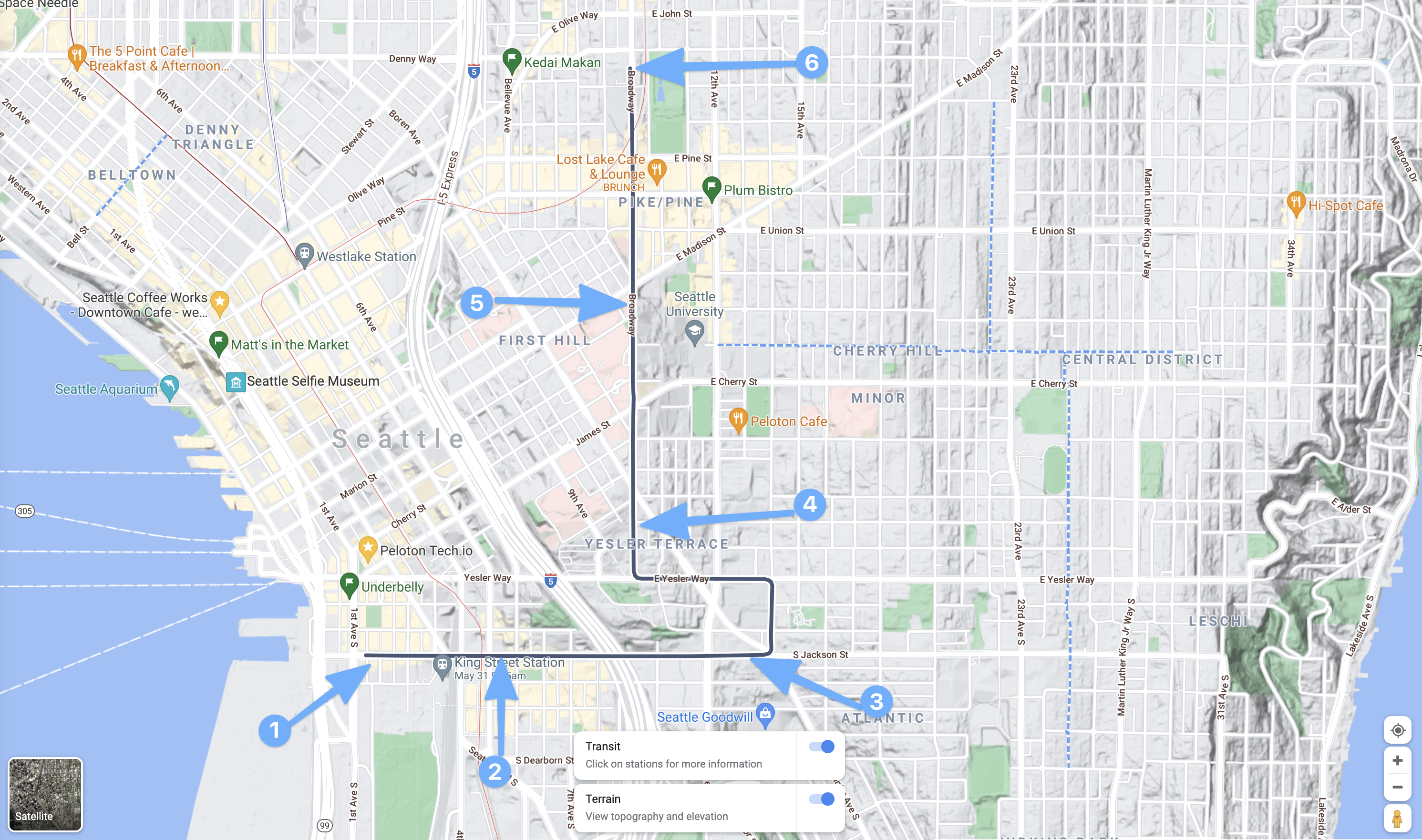
That leads to the first of several maps for the Capitol and First Hill cheats. First up, is the Sound Transit LINK light rail service. The downtown segment of course is just a small snippet of the overall line, but that’s perfect as it gets us up the hill pretty quickly and easily. One can board at Westlake Station (2 below) or anywhere south really, and then ride to the stop designated by 3, the Capitol Hill stop. Then just take the elevators up to the service. Boom, you’re now at Cal Anderson Park (the big green park there near 3) and can get about easily to anywhere in box 1 from the map above. The other hill here, is climbing from point 1, in the Pioneer Square area up to any point north. Since between 1 and 2 is also a significant, albeit less severe hill, just like going from point 2 to point 3.

Next up, the Capitol Hill Steetcar.
This is a great option, the downside being it is really slow compared to the LINK and even when exhausted, it’s probably faster by leaps and bounds to just ride. But hey, we’re talking about being super lazy here!
Starting in the Pioneer Square are, start at 1 to 2 is almost no hill, but provide two stop to board. Then 3 is up towards the midway point on the hill and near some pretty awesome asian food places! As is, of course 2 and the not shown stop between 2 and 3. Getting to 4 reaches the top of First Hill near the hospital zone. Which is great to deboard and then just downhill it to 12th, Broadway, or over to 12th to swing into any of those joints. Staying aboard though, while piddling the day away reading a novel or something, you can climb the next hill to point 5 and onward to the end of the link on Capitol Hill for the easiest of access via all downhill at that point.
Except of course for the final peak, of the second red rectangle from the first map. That one, is only accessible via hill cheats by boarding a bus and racking the bike. Some I tend to refrain from doing except at my most laziest (which is still pretty frequent). That’s where this next map comes into play, it’s a soup of buses and all that which King County Metro operates.
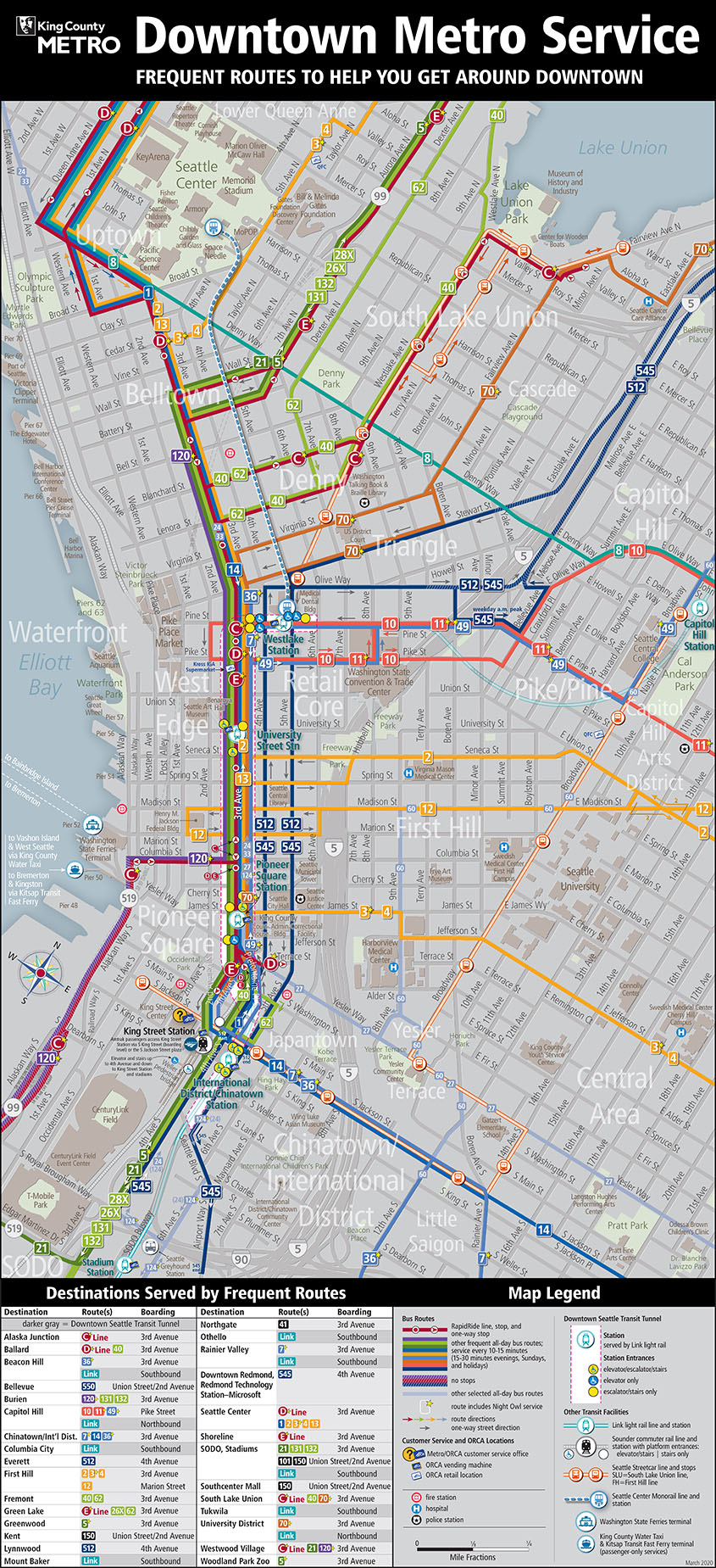
On the above map, the busses that’ll get you to the very top (rectangle 2 in the first map), include 10, 11, 12, and 2. To get to the top of, if for example you don’t want to swing into the tunnel for the LINK or board the Capitol Hill Streetcar, First Hill board the 2, 12, 3, or 4. They’ll all get you up the super steep hills! Two other bus options that will get you into the 1 rectangle in the first map, include the 48 and 49 busses. If you’re aim is to just cheat yourself into a nice lazy ride to the 1 rectangle, any of these busses will work. Which means there are multiple places downtown that you can board, or from other points in downtown, to get up the hill without needing to put in any excessive amount of energy!
As a freebie, it’s also fun to just take the transit up, then have a downhill ride for the hell of it! 🤙🏻
That’s it for my Capital Hill cheats, I’m thinking about writing up Phinney Ridge or maybe Magnolia or Beacon Hill cheats next. Let me know if you’ve got a hill in Seattle you’d like cheats for and I’ll build up a list of routes.

In Hamilton ON, the transit service offers free bus rides for people with their bikes (on a conventional rack) between designated stops at the bottom and top of the Niagara escarpment: https://www.hamilton.ca/streets-transportation/biking-cyclists/integration-transit
Oh what! That’s super cool!
where’s my pic of train #500???
On my phone! 😛