Light Rail!

Every Bus, Train, and Ferry in Puget Sound — On One Live Map

Every bus. Every train. Every ferry. Right now, moving, on one map.

Not a schedule. Not a “planned frequency” PDF. Not a rendering in some agency slide deck. The actual vehicles, where they actually are, this actual minute.

I found it at dashingarrivals.com, and I’ve lost an embarrassing number of minutes to it since. It’s a live map of the whole Puget Sound transit system — King County Metro, Sound Transit, Community Transit, Pierce, Kitsap, Everett, and the Washington State Ferries — all of it, all at once. On a weekday afternoon that’s north of 1,100 vehicles breathing across the screen. And yes, I’ve been sleuthing it. That’s the whole point of this blog, isn’t it.

The Whole Region, Live
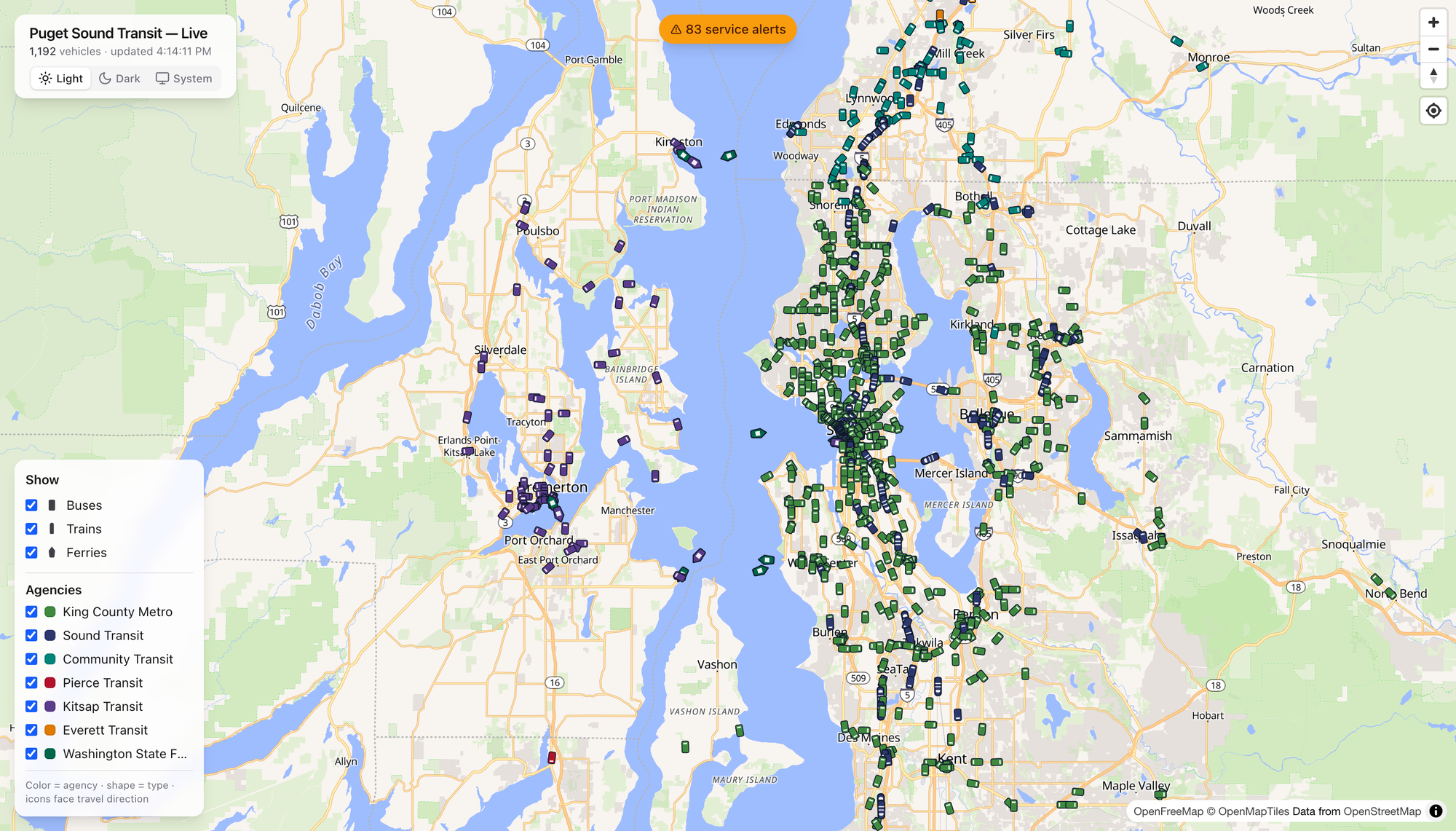
Here’s the thing that got me. Open it up and the region just… resolves. Green dots pour down the I-5 spine. Teal Community Transit coaches fan out across Snohomish County. Purple Kitsap buses cluster around Bremerton, and the ferries — the ferries — leave little wakes across the middle of the Sound like they’ve got somewhere to be. Which they do.

The legend is honest and simple: color is the agency, shape is the mode, and every icon points the way it’s traveling. That’s it. No account, no app store, no dark patterns. You just watch the region move.

Click a Boat, Meet the Tacoma
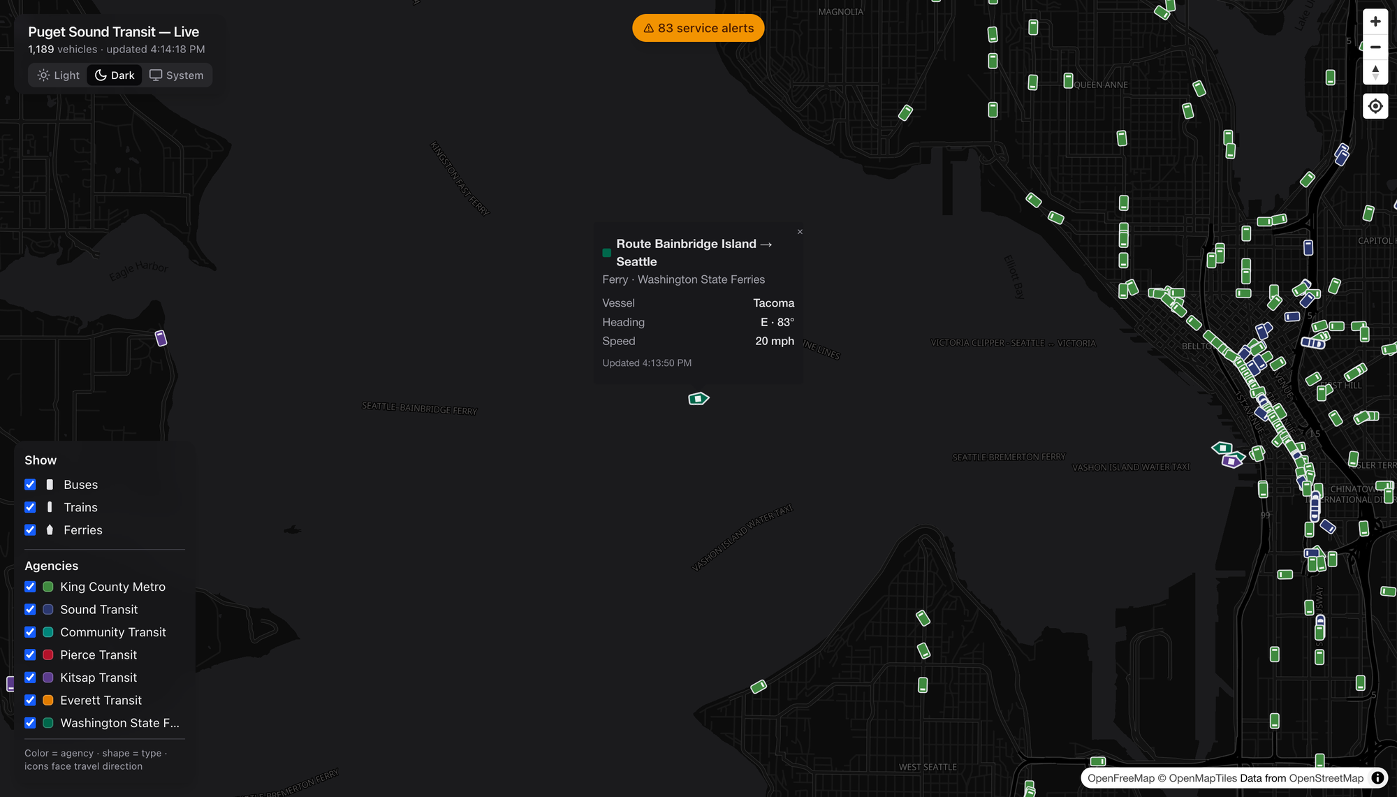
Tap any vehicle and it introduces itself. I clicked a green diamond mid-crossing and got the Tacoma — a Washington State Ferry, Bainbridge Island → Seattle, heading east at 20 knots. A named boat. I did not need that detail to live my life. I loved having it anyway.

Buses give you the coach number, trains give you the car, and everybody gives you heading, speed, and the last time they phoned home. It’s the kind of granularity that turns a map into a rabbit hole.

Show Me the Route

Every popup has a Show route link, and this is where I stopped being casual about it. Click it and the map draws that vehicle’s entire line — the shape and every stop — under the live vehicles still running it.
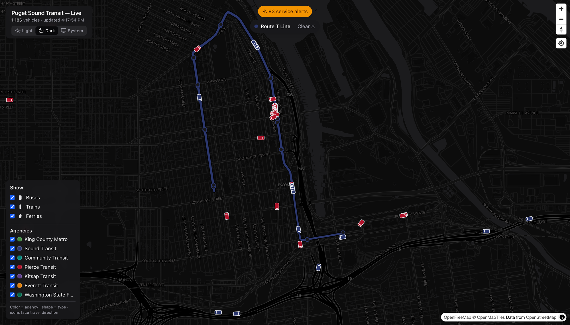
Watch the little T Line streetcar trace its loop through downtown Tacoma, red Pierce Transit coaches swarming around it. It’s a small system. It’s also real, and it’s on the map with everything else.

Rail That Isn’t Just Link

Here’s a public service announcement: the Puget Sound has more rail than most people riding it realize. Sounder is the one folks forget.
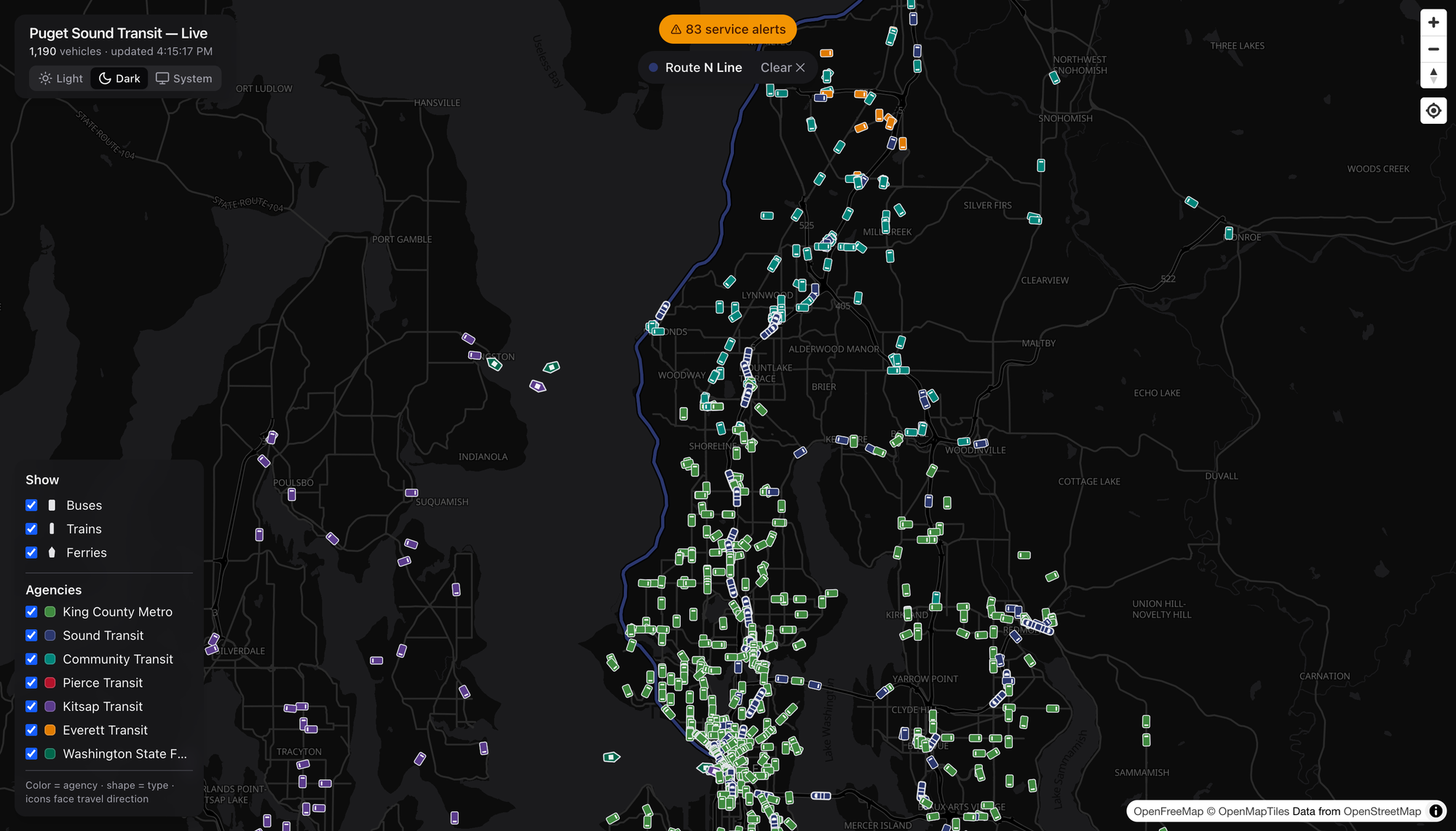
This is the N Line — Sounder commuter rail, Everett down to Seattle, hugging the water past Mukilteo and Edmonds. It only runs at the peaks, so catching a train on the map is a little reward for looking at the right hour. Pull the route up and the whole coastal alignment lights up, with Community Transit teal and Everett Transit orange filling in the last-mile around it. That’s a network — commuter rail doing the trunk, buses doing the capillaries.

Buses Get the Same Treatment

The route trick works for anything with wheels, which means you can finally see what a line actually does.
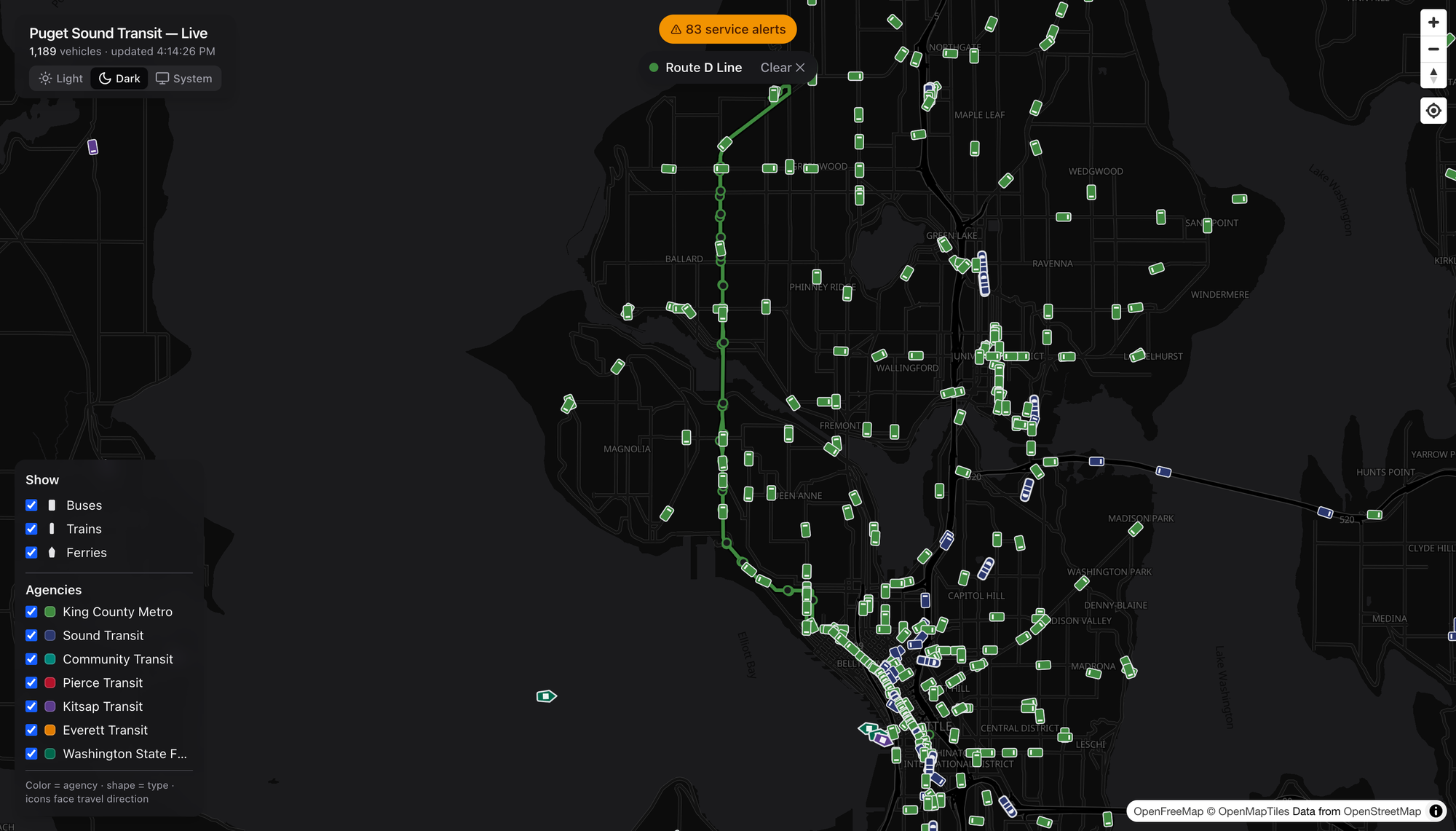
The RapidRide D Line in Metro green — Crown Hill and Ballard down through Interbay into downtown.
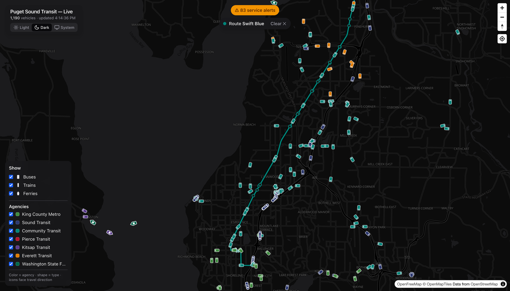
Community Transit’s Swift Blue in teal, running BRT straight down the old Highway 99 corridor from Everett to Shoreline — the kind of frequent, legible, get-on-and-go line I wish we built ten more of.
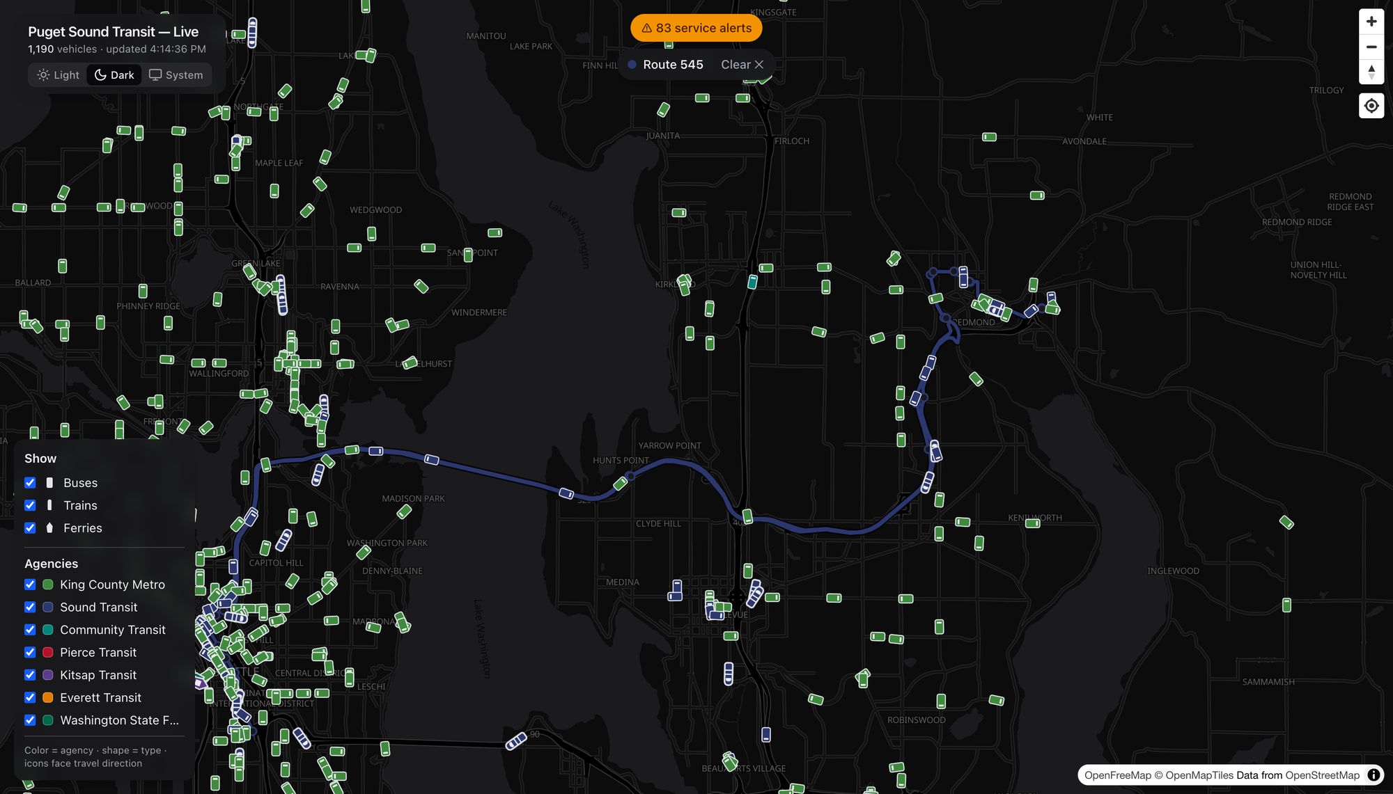
And the ST Express 545 in Sound Transit blue, humming across the 520 bridge to Redmond. Lettered RapidRide, numbered local, Swift, ST Express — pick any of them and the corridor lights up the same clean way.

Filter Down to One Agency

Eleven-hundred vehicles is a glorious mess. So dial it in.
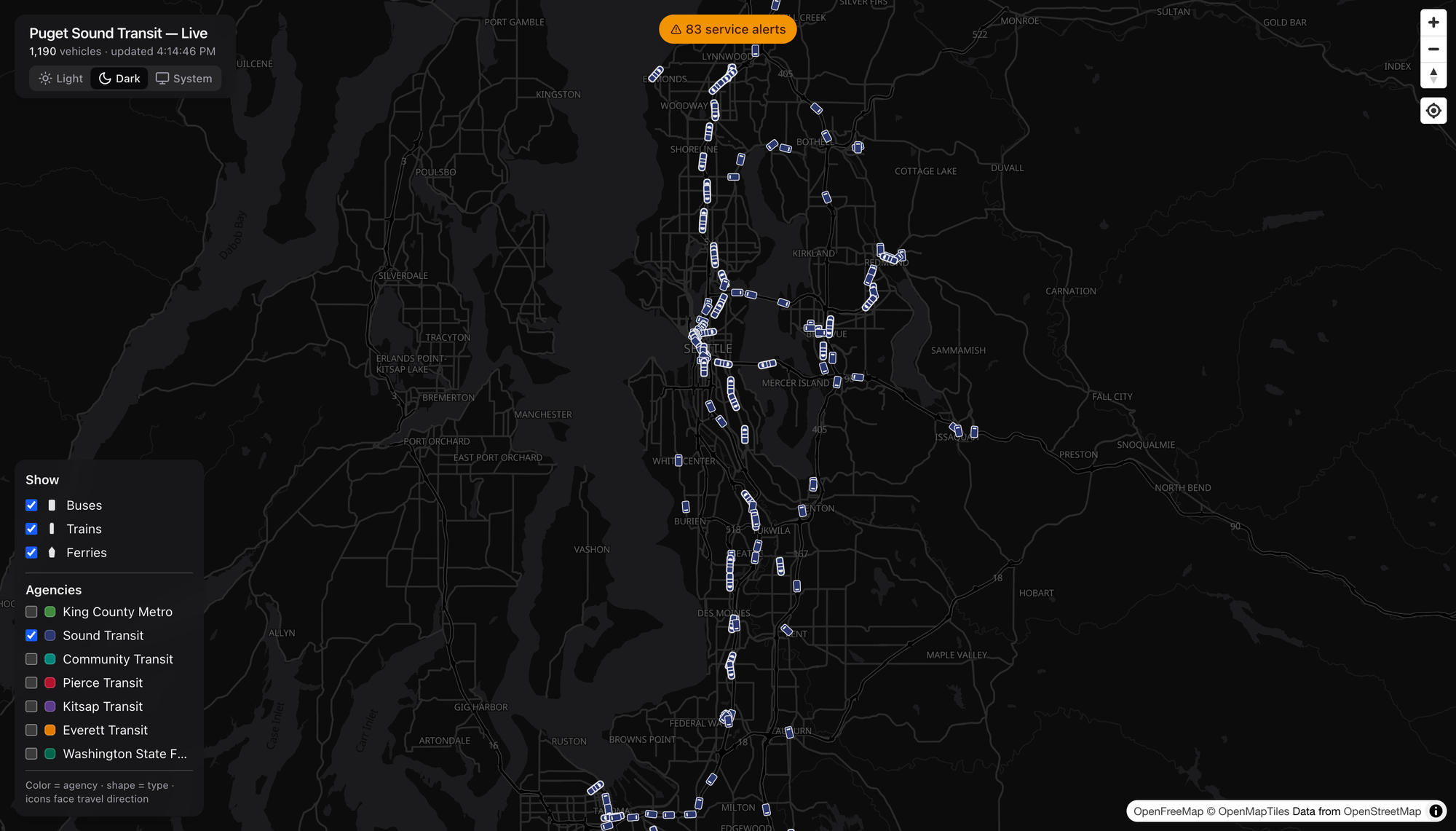
I unchecked every agency but Sound Transit, and there it is — the ST spider laid bare. Link threading north–south and across the lake, Sounder on the corridors, the T Line way down in Tacoma, ST Express filling the gaps to Redmond and Issaquah. One toggle and you’ve got the regional operator’s entire footprint, nobody else’s. Do the same with the modes and you can strip it down to just the boats if you want. (I want.)

When’s the Damn Bus
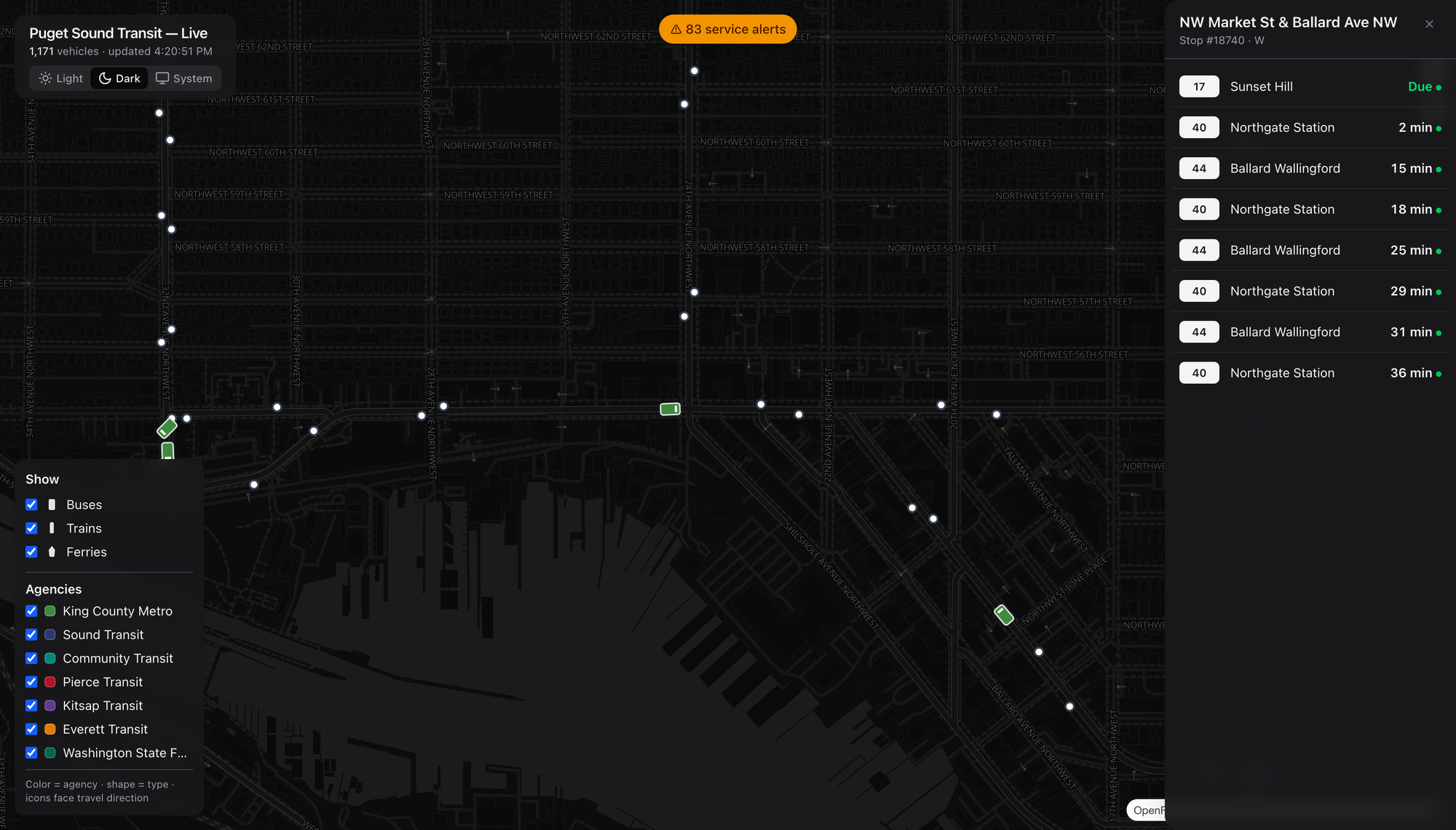
Zoom in and the stops appear. Click one — I grabbed NW Market & Ballard Ave — and you get a live arrivals board: the 17 to Sunset Hill due, a 40 to Northgate in two minutes, the 44 behind it. Real predictions with real countdowns, the same numbers you’d squint at on the sign, except you’re looking three blocks ahead before you leave the house. This is the part that’s actually useful, not just fun.

The Disruption Board
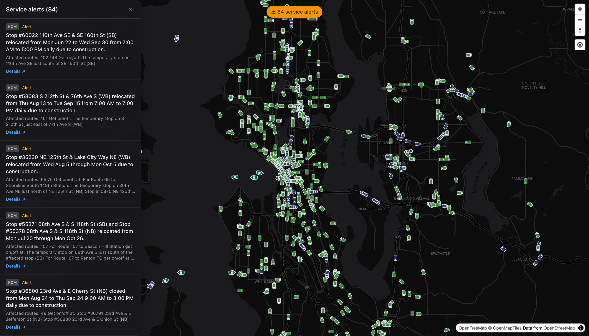
There’s a running count of active service alerts up top — reroutes, stop closures, construction, the usual regional churn — and opening it gives you every one, with the agency, the affected routes, and where to actually catch your bus in the meantime. It’s the “what’s broken right now” board for the whole Sound in a single scroll. Boring? Sure. Boring is exactly what you want from transit information.

Dark or Light, Reader’s Choice
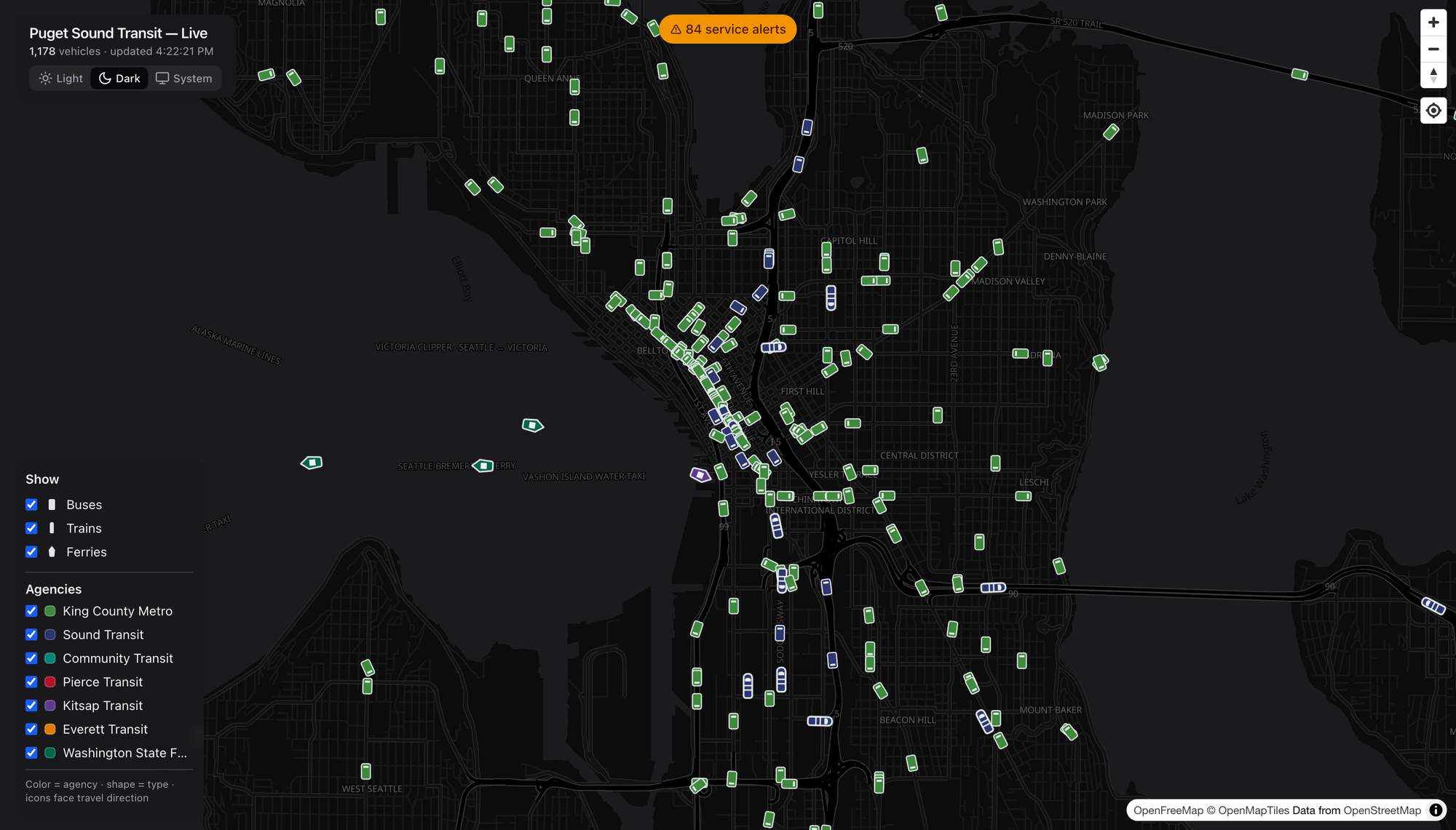
There’s a theme toggle — a crisp dark basemap for the night owls and vehicle-watchers, a bright one for daylight planning, and a System setting if you’d rather it just follow your machine. Same live data, different mood. I keep it dark. Obviously.

What I’d Watch

A few honest notes, because I can’t help myself:

  • Coverage is only as good as the feeds. This rides on the region’s OneBusAway data (plus WSDOT for the boats), so if an agency’s real-time feed hiccups, the map hiccups with it. Not the map’s fault — but it’s the ceiling.
  • Sounder and the T Line are peak-and-place dependent. Show up off-peak and the commuter rail is simply gone from the screen. That’s the schedule, not a bug, but a first-timer might not know to look at 5pm on a Tuesday.
  • This is a watcher’s tool that happens to be a rider’s tool. The arrivals and alerts make it genuinely practical, but the joy is in the whole-region view — and joy is a perfectly good reason for a thing to exist.

The Bottom Line

We spend a lot of energy in this country pretending transit is invisible — burying it under the regional asphalt car-sewer ritual until nobody can picture the network even existing. A map like this does the opposite. It makes the system legible. You can see, at a glance, that the Puget Sound already moves an enormous number of people by rail, bus, and boat every single minute of the day.

Go look. Click a ferry. Show a route. Find a stop near you and watch the next three buses roll toward it. Then go ride one — the best discoveries are always at the other end of a line you hadn’t tried yet.

Enjoy your day dear readers, cheers! 🚈

dashingarrivals.com


Screenshots grabbed live from dashingarrivals.com. Basemap © OpenFreeMap / OpenMapTiles, data © OpenStreetMap contributors. Real-time feeds via OneBusAway and WSDOT.
Cheating Hills

Ever since I moved to Seattle some years back, I’ve ridden all over the city pretty much all the time, any weather, by bike. But even amidst all this riding combined with tons of requisite hill climbing, I do enjoy cheating a hill climb every now and again. These are some of the ways I do this, and a giant thanks to KC Metro and Sound Transit for providing solid, reliable, and kick ass services to be able to pull off these hill cheats!

Capitol & First Hill Cheats

The easiest ways when riding to get up to the top of Capitol or First Hill, or mostly to the top of Capitol or First Hill, is to use the LINK, and secondarily the Capitol Hill Streetcar (which is by no means fast, but it’s real easy). The reason I bring up these two modes as the easiest, is because you can just roll on and roll off with a bike. No need to rack anything or go to any trouble, just on and off, with an ORCA swipe off of the vehicle. Let’s take a further look at the map of these two options, but first we should look at where the tops of Capitol/First Hills are here.

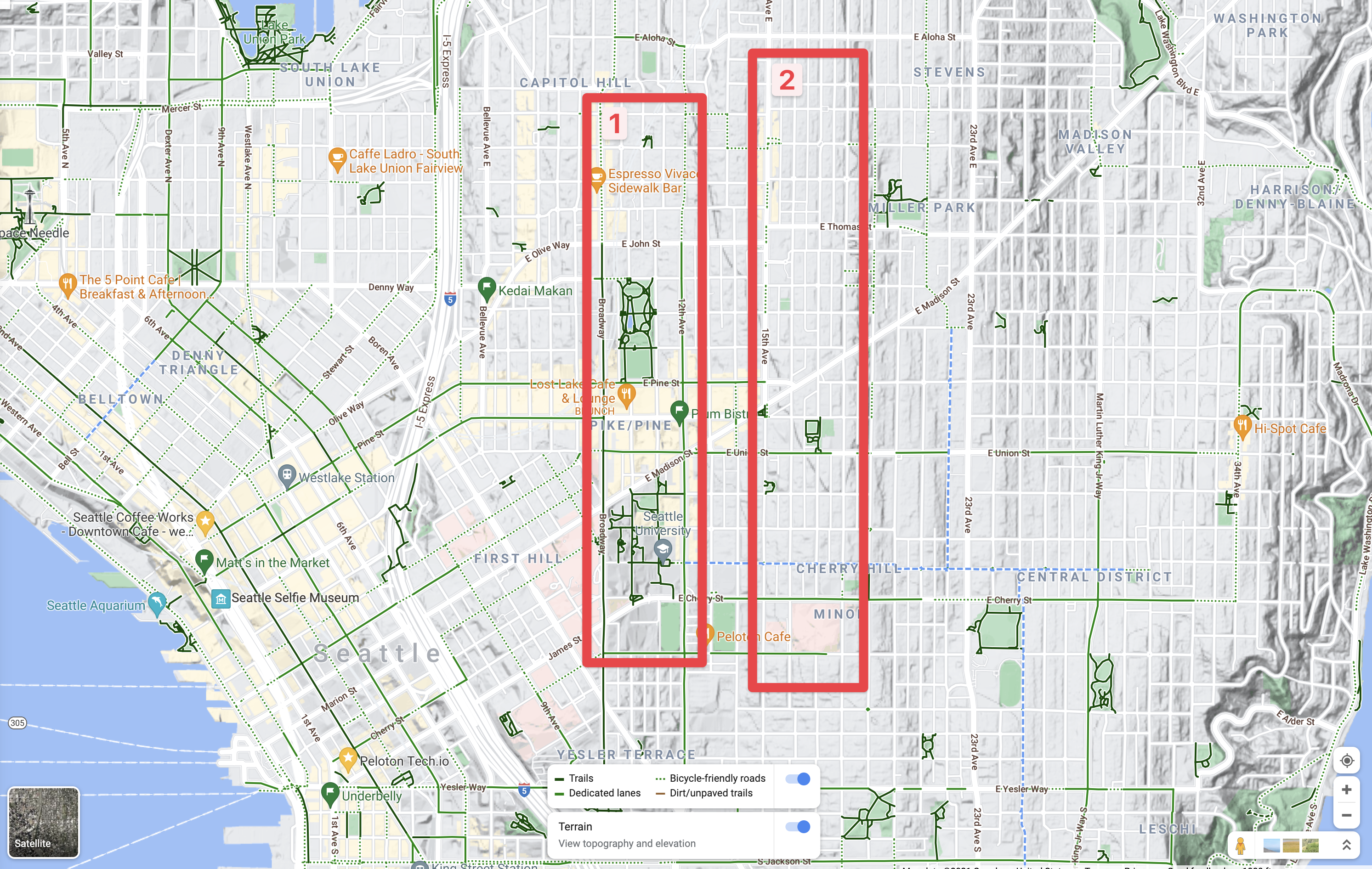
The two hill tops.

On this map above there are the two red rectangles, 1 is of the first and largely most populace and business heavy area of Capital Hill and First Hill. The 2 rectangle is of the higher, and has less business and more residential part of Capital and First Hills. Both areas have things anyone in Seattle will generally want to swing by on a semi-frequent basis if they’re into food, art, music, parks, or what not. It is, after all, pretty much the heart of downtown here. To the right of the 2 rectangle leads to Central District, Madison Valley, which is a huge drop from the hill tops. The other directions, such as westward into downtown Seattle are both huge drops from areas 1 and 2.

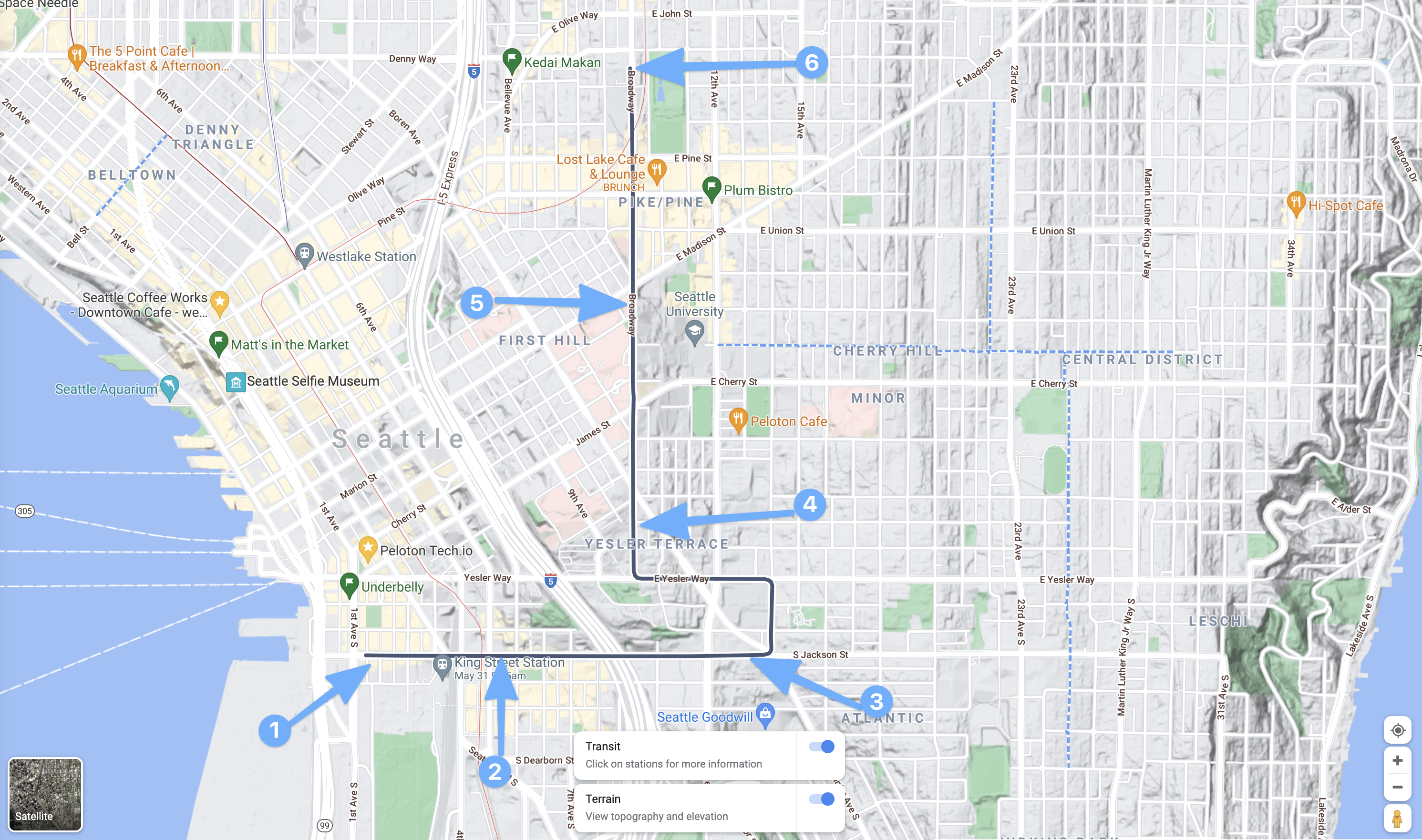
That leads to the first of several maps for the Capitol and First Hill cheats. First up, is the Sound Transit LINK light rail service. The downtown segment of course is just a small snippet of the overall line, but that’s perfect as it gets us up the hill pretty quickly and easily. One can board at Westlake Station (2 below) or anywhere south really, and then ride to the stop designated by 3, the Capitol Hill stop. Then just take the elevators up to the service. Boom, you’re now at Cal Anderson Park (the big green park there near 3) and can get about easily to anywhere in box 1 from the map above. The other hill here, is climbing from point 1, in the Pioneer Square area up to any point north. Since between 1 and 2 is also a significant, albeit less severe hill, just like going from point 2 to point 3.

The Sound Transit LINK Service, that red line on the map.

Next up, the Capitol Hill Steetcar.

Capital Hill Streetcar

This is a great option, the downside being it is really slow compared to the LINK and even when exhausted, it’s probably faster by leaps and bounds to just ride. But hey, we’re talking about being super lazy here!

Starting in the Pioneer Square are, start at 1 to 2 is almost no hill, but provide two stop to board. Then 3 is up towards the midway point on the hill and near some pretty awesome asian food places! As is, of course 2 and the not shown stop between 2 and 3. Getting to 4 reaches the top of First Hill near the hospital zone. Which is great to deboard and then just downhill it to 12th, Broadway, or over to 12th to swing into any of those joints. Staying aboard though, while piddling the day away reading a novel or something, you can climb the next hill to point 5 and onward to the end of the link on Capitol Hill for the easiest of access via all downhill at that point.

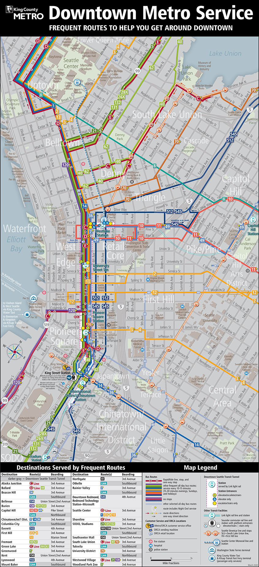
Except of course for the final peak, of the second red rectangle from the first map. That one, is only accessible via hill cheats by boarding a bus and racking the bike. Some I tend to refrain from doing except at my most laziest (which is still pretty frequent). That’s where this next map comes into play, it’s a soup of buses and all that which King County Metro operates.

King County Metro Busses

On the above map, the busses that’ll get you to the very top (rectangle 2 in the first map), include 10, 11, 12, and 2. To get to the top of, if for example you don’t want to swing into the tunnel for the LINK or board the Capitol Hill Streetcar, First Hill board the 2, 12, 3, or 4. They’ll all get you up the super steep hills! Two other bus options that will get you into the 1 rectangle in the first map, include the 48 and 49 busses. If you’re aim is to just cheat yourself into a nice lazy ride to the 1 rectangle, any of these busses will work. Which means there are multiple places downtown that you can board, or from other points in downtown, to get up the hill without needing to put in any excessive amount of energy!

As a freebie, it’s also fun to just take the transit up, then have a downhill ride for the hell of it! 🤙🏻

That’s it for my Capital Hill cheats, I’m thinking about writing up Phinney Ridge or maybe Magnolia or Beacon Hill cheats next. Let me know if you’ve got a hill in Seattle you’d like cheats for and I’ll build up a list of routes.

Observations of Krakow

Today I’ve gone out and ridden several of the Krakow tram lines. The map shown below gives you a good idea of a well built transit system with appropriate redundancies, requency, and overlapping lines to actually connect inner core city areas with outerlying areas, all crisscrossed with appropriate cocnnecting bus service for lower ridership local style service and a lot of 60 foot bus service.

The trams operate almost entirely in dedicated right of way, except in the old city inner core. Everywhere else they operate in medians, dedicated routes, tunnels, and other pathways that allow them unencumbered travel. This makes for easy frequency and timely travel that rivals that of auto-travel along similar routes. In rush hour it is easily the fastest, except for bicycling, way to travel throughout the inner core and immediate outter regions of the city.

A thought for comparing Portland to Krakow is, don’t. The comparisons really aren’t even close to apples to apples, however there are many things each city could learn from each other. Let’s take a look at a few of those learned lessons, by looking at each city. Not to compare competitively but to see from a learning perspective. (If we can do that) 😉

The trams and Portland’s streetcar and light rail operate in similar ways, at certain times. Both have some tunnel, but not much. Krakow has a tunnel that has two stops near Krakow Glowny, the main train station. In Portland we of course have the tunnel with the elevator to the Zoo and a minor cut and cover style tunnel at Gateway.

Both tram/light rail systems have street running, that is theoretically dedicated, but often mixes with traffic. Both also mix heavily with pedestrians, which honestly in both cities is much safer than the actual automobiles mixing with pedestrians. One major difference I noticed however was the delivery vehicles that come into the city core aren’t the type that would dismember or kill people the way they do in American cities. Anything coming into or out of the pedestrian heavy city core is generally traveling slow speeds and operated in an extremely safe manner. This is something Portland could very well learn and adapt a few rules on.

{Operational Observation}

The 3rd day I was in town some jack ass driver ran into the tram. I noticed an immediate difference in how things get resolved here versus in the United States. In the US, the police would likely need to come, some supervisor would need to show up, and in the meantime that entire tram/light rail vehicle would have to just sit there causing congestion among the entire transit system. In Krakow however the tram driver cursed at the driver to get out of the way, and then the driver took their dented and damaged Mini Cooper and got out of the way. The tram then continued on it’s way since both vehicle were still operative. As should be the case, the Mini Cooper driver would just have to deal with all of their stupidity and cover the costs of damage themselves without interupting the entire transit line! I was impressed!  (I also know, from hitting a pole with a Mini Cooper once, that the damage would be about $3000 dollars!)

Population and Geography

Both cities have unique landscapes to build around, as do all cities. Portland has many hills, two rivers, ancient volcanoes, and other geographic terrain to build around. Krakow is relatively flat, with thick forrests and greenery with a twisting river running through the city.

One city is hundreds and hundreds of years old, the other is barely over a century old. Portland has about 600k people living in the inner core and about 700k living outside of the inner core in town centers and sprawling suburbs of single family homes. Krakow has about 430k living in the core, with barely a measurable amount of people living in the surrounding area. Most in Krakow live in flats, or what Americans would call apartments.

{short rant start}
…and dont even look down at that notion, they’re doing just as good as single family home owners in life with those flats. If you scoff at that notion as Americans do sometimes, you’re showing your damnable ignorance. If anything it shows how deeply suckered you are by the marketing for “space space space!” Space doesn’t get you a loving family, a vibrant life, or otherwise.
{short rant over}

In the inner core of Portland, as in the inner core of Krakow everything is very walkable. There is zero need for a car in this city, albeit about 50-60% of the population uses a car on a regular basis to do something. Around 40-60% use a car to commute. In Portland of course, about 40-60% also use a car to commute into and out of the city inside Portland city itself, however outside the core about 95% commute into the city by car.

Portland and Krakow both have job centers distributed throughout the urban core of the city. In Portland the metropolitan area includes other town centers and job center areas such as the west side like Beaverton, Hillsboro, Intel, Nike, Vancouver also has several sprawled out job centers. This is something that does set Portland apart, in the number of jobs that are located well outside of the actual city itself.

Another key thing I’ve notied is the city of Krakow is an atomic city. There’s a huge Soviet Atomic energy plant just to the south eastern section of the city. It’s barely 1-2 kilometers away from where I’m actually staying. I have to admit it is somewhat forboding, however I know it’s doing volumes to keep the air clean compared to the horrid coal plants that would prospectively be here otherwise.

Even with the clean energy of the atom being provided, the city manages to get some strange toxic smells and is even smoggy on some days. When I say smoggy, I’m talking about Los Angeles level smoggy. I’m not sure what plants or other pollutants are cast into the air, but they are definitely there.

People

Polish people have a diet similar to that of Americans, albeit they eat dramatically less food. By proxy, I’ve seen two people that could be termed obese by American standards. Only two. Honestly, this is kind of a surreal experience because everyone simply looks very different because of this. Albeit we’re an extremely similar people, there are after all there have been many Polish immigrants come to the United States. Everyone else looks extremely healthy and fit in comparing to the average American, which makes me wonder what differences in lifestyle allow this. Again, this is just merely an observation of all the people I’ve seen so far here in Krakow. So just like Portland isn’t like the rest of the US so may Krakow be and outlier in Poland.

People in Poland also dress conservatively. Portland people dress however they want with all sorts of absurdities thrown in for good measure. In America in general people dress frumpy like they’re a walking catastrophe that don’t know how to purchase cloths that actually fit on their respective bodies. The difference at first glance might seem small, but the differences become very noticable after a couple of hours.

But Polish men generally dress in fitting jeans or slacks (for business), with tshirts or other comfortable and casual button
ups. Often wearing nice shoes of fair quality that look good.

Women dress very attractively in Poland. Pencil skirts, leather skirts, conservative leather jackets, blouses, jeans, shorts, tshirts, and the like. There is a distinctive cut off however right around 45-50 where women seem to shift entirely to long soft colored pencil skirts that run to the ankles and blouses that easily classify these happy ladies (that to Americans might seem grumpy, but they’re not, Communism fell after all and they’re real aware of this fact) remind me of merry grandmothers going about their business without a care in the world about the modern rat race.

Languages

Another thing I’ve noticed, that obviously differs from Portland and also other trips to western Europe.

In Portland, people speak English almost entirely. If you don’t speak english in Portland you basically are going to have an extremely hard time doing anything on a regular basis.

In Krakow you can speak english or polish and get by very very well. You could also speak russian and probably do very well too, just from the similarities in many words and such. Also, if you know Italian words for food, you’re also not going to go hungry if you eat out. There are Italian Coffee shops and places to eat everywhere. Italian food is easily more popular in these parts that Polish food actually is!

The difference in languages that I’ve seen between Poland and western european (north western I should add: Germany, Denmark, Sweden, Netherlands, etc) countries is that most conversations start in Polish here, and almost the entirety of conversations in northern western european countries start in english. Often even conversations among locals in those countries start in english but in Poland you know when locals are speaking to each other beccause it is very clearly Polish.

I assume, again I have to research this theory, that Poland having english as a signficant language goes back to the formation and inclusion of Poland in the European Union. Where as the north western european countries like the Netherlands, Denmark, Sweden, and other countries had started speaking english far before (likely in a significant way after WWII, but really even before that) Poland did. Also, Poland had to deal with decades of russian influence where english was absolutely not a preferrred language to know. With that in mind, the youth in Poland today (< 30) are the first generation(s) that actually had the opportunity to learn english as a core language.

Other Notes

A few other things that I have noticed that I find fascinating. Some of these are just interesting to me and others I’ve noted as they would drive me crazy since some things in America have me spoiled.

Note: Grocery Stores

{partial rant start}
Oh my god I want my natural, organic, non-mutated farm produce and meat! I want it now! Krakow, from what I’ve been able to determine, has no actual fresh food and produce. I realize America generally doesn’t either, but living in Portland has me ridiculously spoiled and dammit I want some fresh fish, some vegetables that were picked a few hours ago. I want something I know hasn’t been flash frozen!

The grocery stores here are the equivalent of Wal-mart style … how should I put it? Shit? The food just isn’t good in the grocery stores. The restaraunts are pretty good, I wonder where they get their food? Maybe they just inject tasty into it somehow? I don’t know.

But the last thing, which is such a small thing, but it makes me nuts. I don’t care about needing to buy a bag, or expectation that I should have my own bag for groceries (because in portland that’s how I roll anyway because I’m not a wasteful asshole). But what does bug me, is I have to hurriedly bag my own stuff (in my bag or the one I just bought) and quickly get out of the way myself at the grocery store.

That by itself might not be so bad, but combine that with the lack of a smile and a hello (even a Polish one that I only recently understood) would be an improvement, but instead the cashier just sits there like a machine, poking the buttons quickly and shoving you along to bag your groceries. This makes me miss New Seasons or even *gasp*
{partial rant complete}

Summary

So far I’m thoroughly impressed by Krakow. In the coming days I’ll be trying out many of their cycle tracks and river runs. So I’ll have a lot more to add to all of this, as biking is a legitimate and regular thing that people make use of here in Krakow. So stay tuned… more to come!

Just Daily Portland Trips

A few weeks ago I took a trip around Portland and snagged some photos. I used a varying arrange of modes; streetcar, light rail, bus, bicycle and my own two feet. This is a pretty standard trip that could easily be told in pictures. Which is what I’ll do now, tell the small part of the day along with a respective picture. For all the pictures go here: http://photos.adron.me/Portland-Action/2014-Rolls-On-Up/Bikes-Buses-Streetcars-Car/

Here’s a shot of the streetcar traveling north up MLK. I always like to sit on the right hand side where the two seats face each other. That way I can easily see out the front of the streetcar as we’re rolling along.

Looking Out the Front of the Streetcar (Click for full size image)

Looking Out the Front of the Streetcar (Click for full size image)

I got off near Lloyd Center and snagged a few shots of the light rail trains coming by going east toward Gresham, Clackamas Town Center and the airport and in the other direction those coming into Portland.

Green Line bound for City Center (Click for full size image)

Green Line bound for City Center (Click for full size image)

As things go I saw a number of cyclists among the streets along with the proverbial onslaught of motorists driving their cars.

Cyclists and Motorists (Click for full size image)

Cyclists and Motorists (Click for full size image)

…and then something I see about 1 out of every 7 or 8 trips. Some dipshit motorists that have run into something. In this case someone obviously ran the light and hit the other motorists. Fortunately it appeared that nobody had gotten hurt but I only imagine, everytime I see this sickening situation, how many people might have been killed. In so many places a small negligent act that results in this outcome could have resulted in innocent people being killed. Everything day no less than 13 people, and sometimes as many as 15-20 people are killed by motorists while they simply walk down the street. Sure, one might say callously, that’s a lot number of 300 million people, but consider that this number is about 20-30x higher than in Europe. It really shows that we can indeed reduce these killings. Don’t even get me started on how many motorists other motorists kill, it’s an even higher number at 95-120 people per day and motorists maim another 400-1000 people per day.

Truly unacceptable.

Black Wrecked Car (Click for full size image)

Black Wrecked Car (Click for full size image)

The White Honda Smashed (Click for full size image)

The White Honda Smashed (Click for full size image)

…and more in the near future. Stay safe, think and happy travels. Cheers!