Mission: Record Recon in Seattle “Metro”

I’ve given myself another transit and biking mission in addition to the upcoming posts on the Pittsburgh “Record Recon” missions. Find and recon the record stores in the Seattle “metro” area (obviously right, because I live here!). That includes a lot of territory and I’ll break down with maps and logistics where each of these record stores are and in the coming weeks I’ll be producing a series of videos on each of these shops.
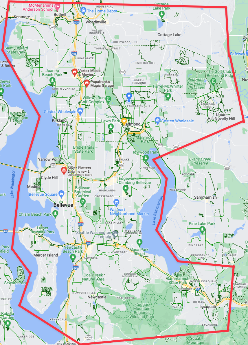
The “Eastside” of the Seattle “Metro”. (Click for larger viewable map)

Now if you’re more interested in just reading about my music collections, reactions to new music, reviews, and all that then check out Vicious Shred. Between that blog and this blog, I try to segment my music specific things from my transit, transportation, and traveling adventures. With that said let’s roll on the record recon!

The Eastside (Seattle “Metro Area”)

Bellevue, Redmond, and the east side in general. This includes the area in the giant pink area. One could generally say “the area between the two major lakes of the area and the wooded northwestern lands of Redmond and Woodinville”. Not that a lot of that area is relevant because the east side simply does NOT have many record stores. However, there are a few, as you can see, which we’ll dive into.
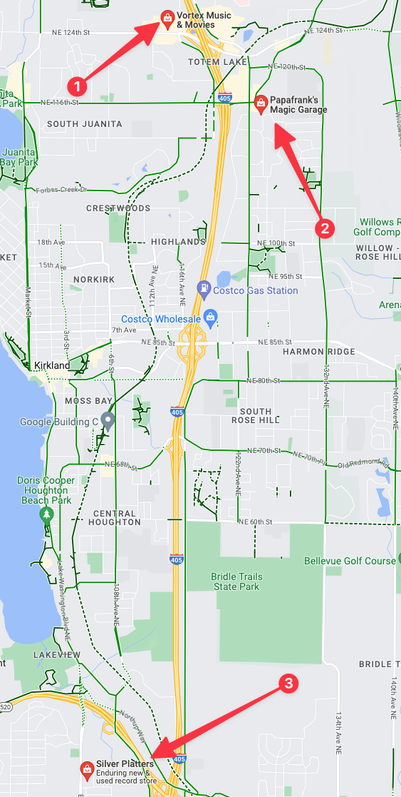
The three record stores (garages?) on the “Eastside”. (Click for larger viewable map)

If we zoom in on the available record stores for the east side they’re all in two places, one is in north Bellevue and the others are in the Totem Lake area. There are only two efficient ways to get to these two area: 1 drive to either of them or 2 bike to either of the locations. Neither are walkable without multiple hours of free time to get to and from them unless you’re located directly inside of these specific areas. Fortunately in *these* suburbs I’ve got some excellent bike route options to get to both locations.

The second option, “Frank’s Garage” is literally Frank’s garage located in a suburban single family home off of any commercial corridor. This is super cool, but also I’ve noted that Frank’s “store hours” are only 1-5pm on Sunday. So that might have to get nixed if I can’t make this trip on a Sunday.

Mission 1

UPDATE: Recon Mission completed on June 14th, 2023. The trip, and record store reviews are available for Vortex Movies & Music and Silver Platters.
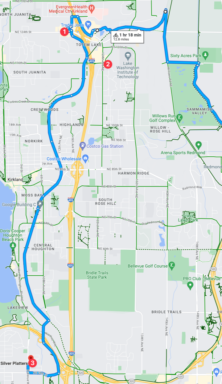
(Click for larger image)

A key bike route is along the Cross Kirkland Corridor, which perfectly maps to nearby locations of all three of the record stores! This means that I theoretically could visit each of the record stores in one trip, efficiently stringing them all together in one voyage! Note that time, I’m going to set myself some specific challenges for this voyage:

  1. Ensure the trip time is less than 1 hour and 18 minutes. Think I can accomplish that? I’m pretty confident I can beat that.
  2. Check out both “Vortex Movies & Music” and “Silver Platters“, and for this first voyage to Eastside record stores I’m going to skip Frank’s since I can’t make a Sunday trip.

With that, this I’ll dub “Mission 1: Seattle Metro Eastside Record Stores Voyage“. But with the Eastside locations covered, let’s move on to the *actual* Seattle record stores.

Seattle (The actual *city*)
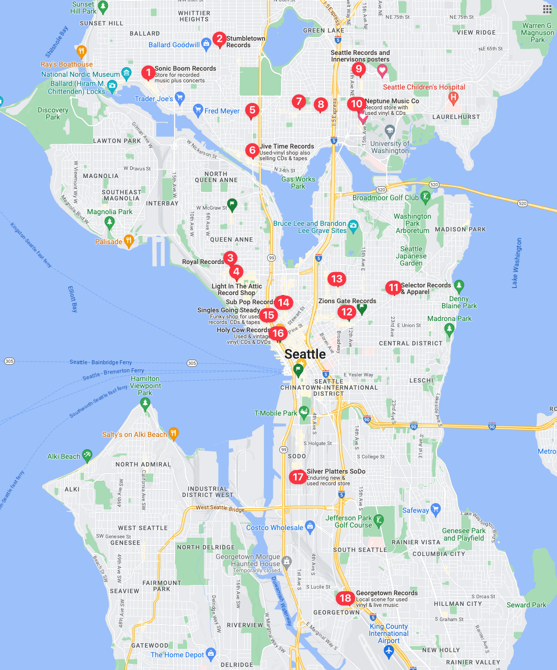
18 Record Shops – That come back in a maps query. There could be more, and if I zoom in…

My first observation, is that there are none in West Seattle, which seems really odd. I’m finding it hard to believe there isn’t a record store over there, as I’m 100% positive that Easy Street Records & Cafe is over there. Which, I’ll get over there for a full review in the coming weeks as it is easily one of the best record shops in the country let alone Seattle.

I’ve done a secondary query and there is indeed multiple record shops that don’t show up in the above, with the addition of Easy Street Records & Cafe showing up in a query of just West Seattle. Then I did another deeper zoomed map query of University District and sure enough, several additional record shops showed up: Neptune Music, Hi Fi Lo Fi, and Al’s Music, Video, & Games in addition to the two shown on the map above.

This is going to be multiple missions compared to the Eastside, as there is no single route that would travel through all of the record stores as there are just too many of them. But with a bit of study and logistical prowess I’ve attained from years of cycling all over Seattle, I’ve got a few plans following a few strategies.

With those extra queries, the 18 record stores in the map turn into 22 stores in Seattle proper! Clearly, if you’re into vinyl and live in Seattle you’d never have to leave the city, it appears Seattle has record store coverage almost everywhere! With 18 stores I’m going to guess I can maybe drop into 3-6 stores per trip, but it could very well be just 2 or more depending on which ones I’m aiming for. Based on routes and clusters of record stores here is the first two that I’ve deemed a priority.

Mission 2
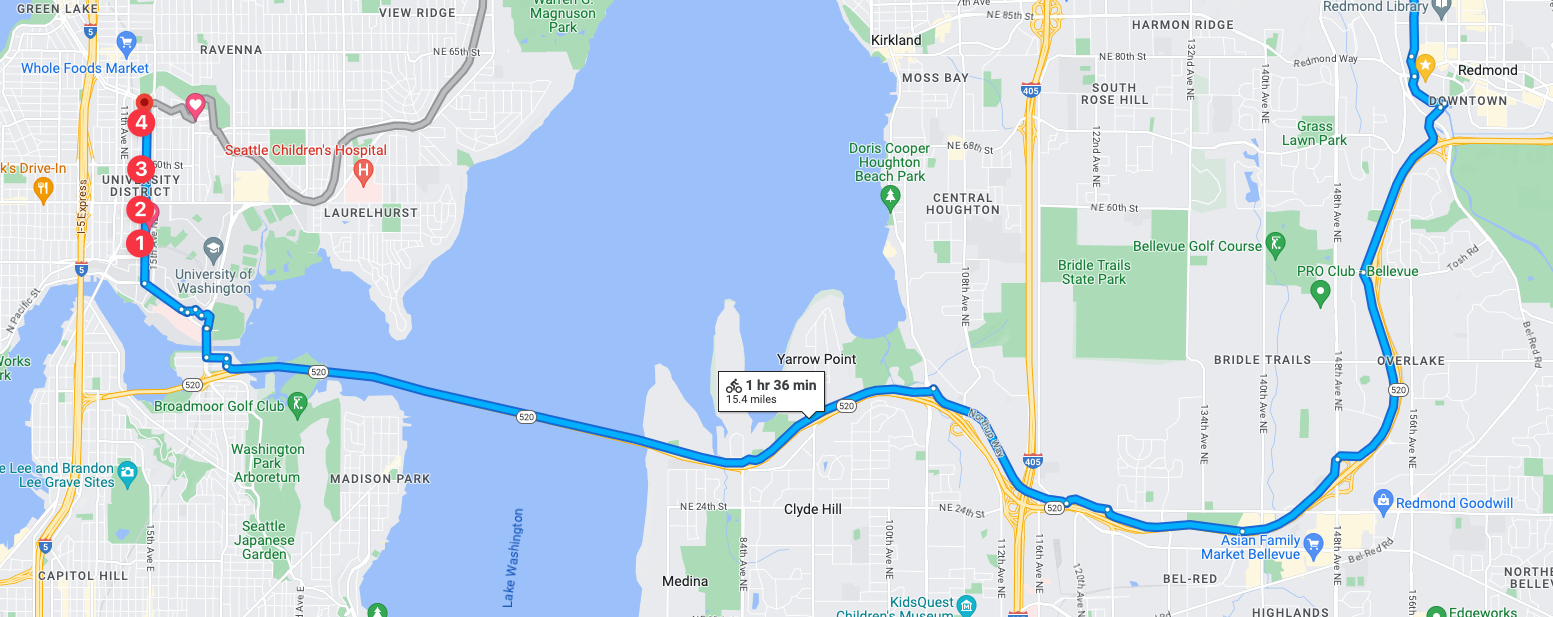
Mission 2 record reconnaissance will be into the University District of Seattle with a goal to visit 4 stores: Neptune Music, Hi Fi Lo Fi, Seattle Records and Innervisions Posters, and Al’s Music, Video, & Games. There is another store that has theoretically opened at 6215 Roosevelt Way NE called Satisfaction Records & CDs that I’ll roll into this mission. It was in Ballard, but as I searched through the characteristics of that mission I had to back track and add it to this mission! Thus, it’s very likely this will be a recon mission with 5 stores!

Mission 3
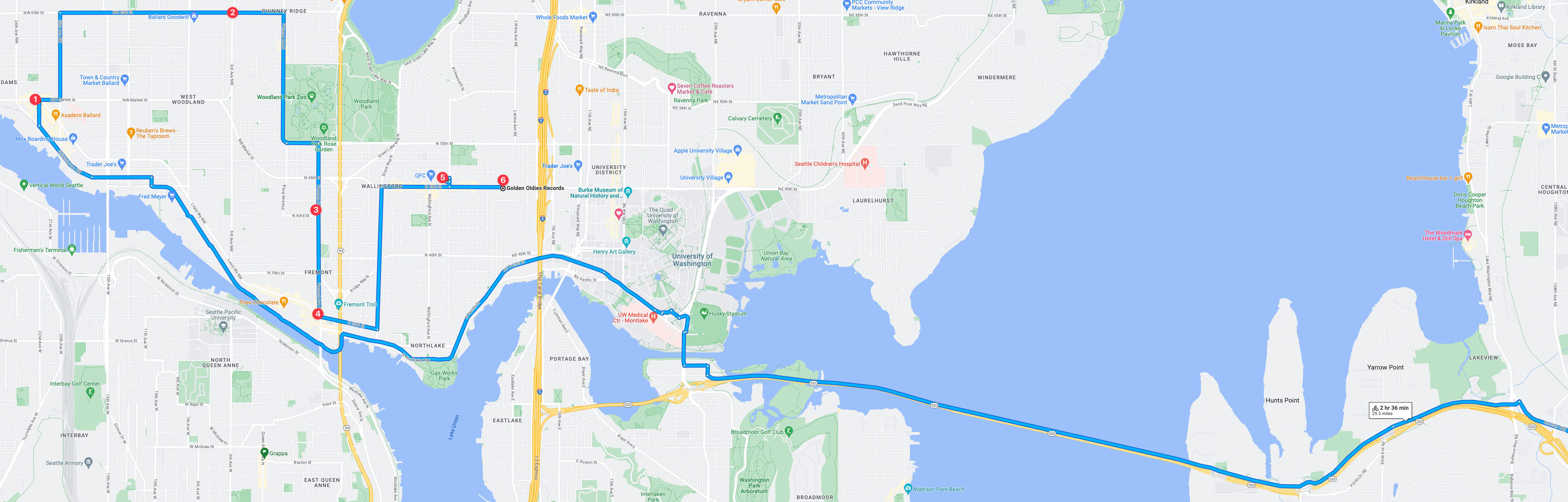
Mission 3 record reconnaissance will be into a trio of neighborhood areas: Wallingford, Fremont, and Ballard. This is extremely familiar territory since not long ago I lived in Ballard and also long ago I lived in Ballard. This reconnaissance run will be the hardest to date at this point with 6 record stores to visit! Will resources be enough? Will time be available? Will the store open hours be enough? It could be tricky but I think I can pull off 6 stores in one trip!

Overall, this mission holds a special place in my heart and mind as it’s in old stomping grounds of 2022 and before! In many ways I do miss Ballard and wish we could have stayed in the neighborhood but alas, to the east we went. But just before we left, one of the old well known record stores closed, which this trip will be a hats off homage to the long years of service of said store – if you know you know. But either way, this trip is gonna be fun to record and fun to log the visits afterwards.

Mission 4
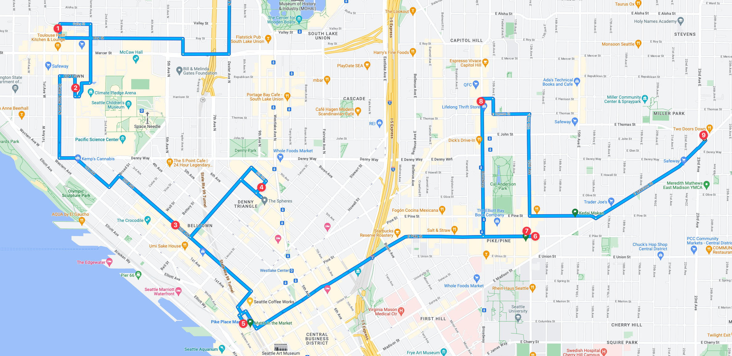
Mission 4 is going to be intense, and I might have to split it in two considering the 9 record stores to recon! I like to spend at minimum 15 minutes checking them out which would put just the time in store at 135 minutes minimum, but likely will be more if even one of. the stores has a great selection that I need to recon more intensely. My personal estimate with that many stores, it would add at least 3 hours or more to the entire recon mission just based on in store time.

Mission 5

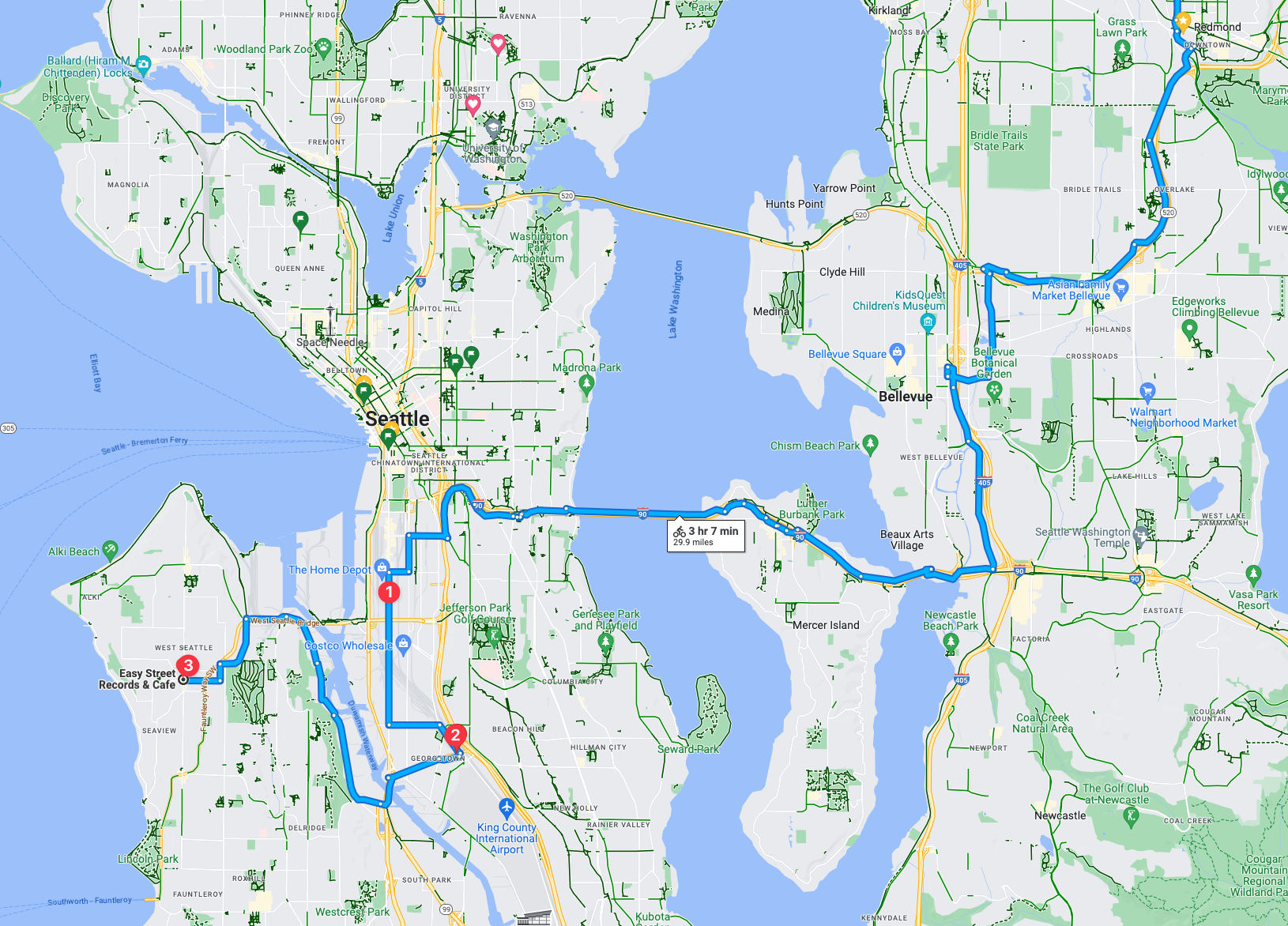
This mission will include a nice trip, albeit long at 3 hours and 7 minutes, it’ll be beautiful ride and an absolute shit ride. This recon trip includes three record stores. One being the Silver Platters SODO location should be pretty good. Then followed with what I understand (and know) to be two of the coolest parts of the city with two a respective awesome record store in each neighborhood.
Tacoma (Not Seattle, but I had to include it!)

Mission 6
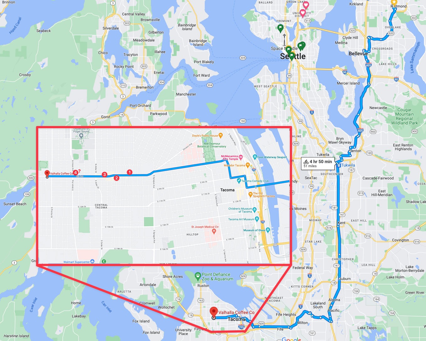
Mission 6 could be so intense from a trip distance, I might just need to interject a train into the mix! After all, trains leave from downtown Seattle and go straight into Tacoma, which would make this trip exponentially easier! But when the mission is on the calendar I’ll narrow it down and confirm the logistics.

Mission 7

Seattle “Metro Area” North is a string areas north of Seattle and south of Everett. I’d go into detail but it’s unnecessarily complicated. Suffice it to say, this trip is going to be long at a suggested 2 hours and 9 minutes, with a significant amount of the trip via trails, amazing. There is still about 15-25% that is on roadway “bike infrastructure” which, in this area, translates to shitty car sewer stroads. But I’ll make due, this is going to be a very interesting recon trip. It’ll also be really interesting if the record stores will validate the trip effort! Hopefully there is a jackpot or two to find among the two.
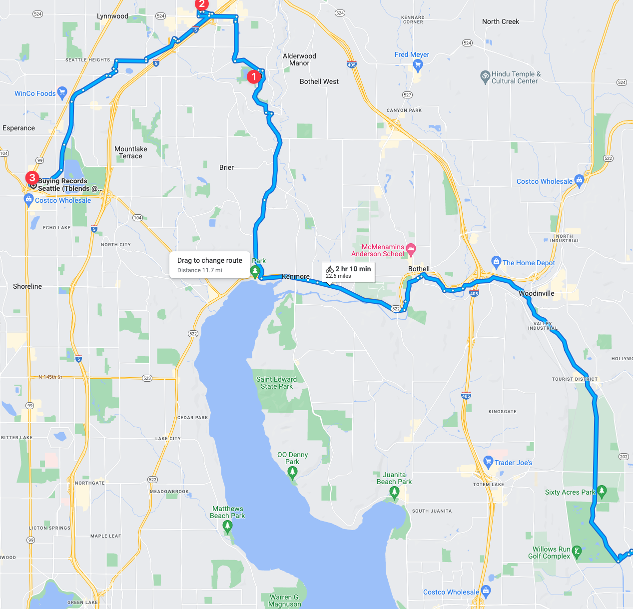
The other thing that isn’t immediately noticeable in this trip is how much of the trip is actually dedicated trails! There are of course some roadways but significant portion of the trip is extensive trail routes! I’m really looking forward to that aspect of the trip.

Mission 8
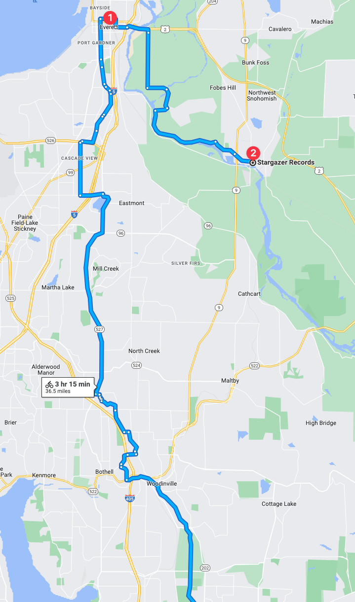
In mission 8 the route is about 50% trail and 50% car sewers so that is going to be a bit of a challenge. Either or though, at some point I intend to complete this mission! These two stores seem fascinating and could be interesting collections unto themselves.

King County Metro (KC Metro) System Maps as of 2022

The following are PDFs of the various areas. There is, as of 2022 a map viewer here.

Wednesdays Videos & Photos

Here’s a few video passes from Wednesday. As yesterday’s, this one has a few blank seconds between each clip.

Here’s a few photos from the day.

Cap n’ Hominy, Bike, LINK, NOLA Bowl, Walkin’, Biking, Green River Trail, Interurban Trail, Sound Transit Sounder

I wrote this absurdly title, but really it’s just a Monday like any other where I don’t have any predefined thing I’m supposed to go do. So the day went like this.

Today started off with a good breakfast. Cajun egg, hominy, and a cappuccino. It’s good to know how to cook the things one likes, otherwise, the food would be boring. The egg and hominy I had some Cajun seasoning, mixed in with some butter, and a touch of salt and pepper. This combination just creates an egg with expansive explosive taste. Not that it’s hot and spicy, just a flavorful combination for something that generally tastes like bland air paste.

Once I wrapped up breakfast I jumped on my pop tart bike and headed to my office maker space. There I tidied up my backpack to just the items I’d want for today’s adventure. With laptop, camera, and related items all packed I rolled down Ballard Avenue and on toward the Burke Gilman Trail.

The weather out today is about as perfect as it gets for cycling. It’s slightly cool out and the sky is clear with the sun at an angle that doesn’t leave one burnt. The air has that crispness to that just makes it easier to breath, keeping the muscles fueled appropriately. I had my water canister with me, as this time with this amazing weather I wasn’t going to let myself get dehydrated and end up feeling lousy the next day! After all, tomorrow I’m planning for another transit and bike combo adventure!

Brunch and The Hills!

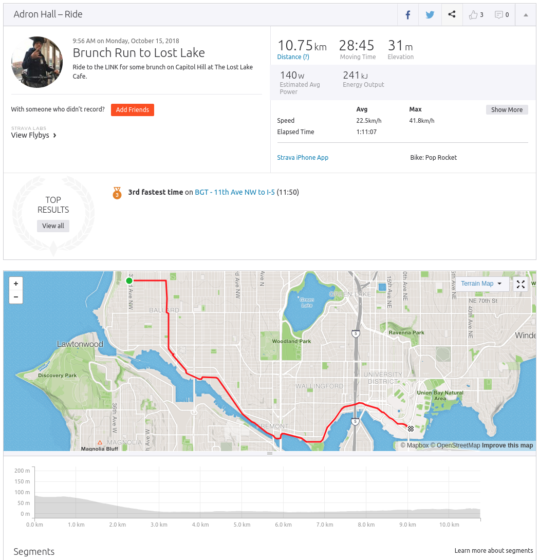
I rolled onward toward the University District LINK Light Rail Station. My plan was to bike over this direction, which takes approximately 25 to 30 minutes and then board the LINK, which depending on waiting time of less than ~10 minutes will get me to Capital Hill with a mere 6 minute ride. Thus, maximum trip with wait would be 16 minutes and minimum would be about 7.

I boarded the elevator into the bowels of the station, and exited to board the train on the eastern side of the platform. I racked the bike in the appropriate place and sat down to wait for departure. In just 3 minutes we left, which meant my trip and wait time would make it 9 minutes. With my combined ride, which I now knew the travel time of 28 minutes and 45 seconds, I was looking at total trip from Ballard to Capital Hill of about ~37 minutes. Not that bad considering I wasn’t really trying nor taking the fatest route, just the most convenient, comfortable, and enjoyable route.

strava-shot.png

My Strava Capture of the ride to University District to catch the LINK

The Lost Lake of Capital Hill

Once I arrived at Capital Hill I exited the LINK station and rode down along 11th toward 10th between Pine & Pike. You see, there’s a lost lake there. Ok, it isn’t really a lost lake, it’s a nifty open 24 hours a day joint that has this kitschy feel to it like a mix between a diner, rustic lodge, and a lounge on the flip side of the space. Brunch and good conversation was had with my friend I’d planned to meet there. Once we were done eating at this lost lake, we opted to take a walk considering that absolutely stellar weather outside.

An aside: Before I go on, I made a mental note and am going to put this in my calendars for the rest of my life. Remember, diligently remember not to schedule any travel whatsoever during the months of October, November, and December, unless of course it is to the northern lands of Europe into Scandinavia or the Netherlands. Those are the only two places that get a pass from me. Otherwise it isn’t worth leaving Cascadia to visit other places as this is the premier perfect weather time of year. At least, in my personal preferences of weather. Slightly cold and growing colder is my perfect cup of tea.

Alright, back to the adventures that laid before me. Upon deciding to walk through Seattle a bit, specifically Capital Hill, First Hill, and on toward Yesler Terrace on down into Chinatown. Well, maybe it isn’t chinatown now and instead it’s International District, considering how few Chinese people actually live there it actually makes more sense. It isn’t just a politically correct rename, but actually a more factual identifier to those that live in this part of the city.

Here’s a few pictures from the walk, as we strolled through Seattle University.

At some point, it was time to start riding. I headed south out of the city. I rode along 6th down onto the trail that runs beside the LINK route out of the city. It’s a nice trail, albeit it ends abruptly with nowhere to really travel once one gets further into the heart of SODO. There I scouted for and rode along a few disappearing sidewalks. This area of Seattle, simply put, it no place for pedestrians or anybody that isn’t basically in some type of motor vehicle. It’s a pretty wretched area. One could argue, “oh but it’s an industrial area!” But that’s just nonsense, just because trucks drive around doesn’t make it a necessity to make it so inhospitable to human activity. People still need to eat, there’s still places to eat, and there’s even some park space and parkway space in the area. So the idea that it’s dirty because it’s an industrial area is just kind of stupid.

I continued onward into a region with no sidewalks, no clearly marked or clearly safe areas to ride. I just followed the premise that if the route was minimal or no traffic, I was going to travel along that route. At some point, and I’m not really sure what area delineated where SODO ends and Georgetown starts, but I passed over a bridge which smelled like human waste and then I was clearly in Georgetown. From there I crossed the oddball intersection that leads into the area, went along the main street of the breweries, breakfast joints, and coffee shops, and onward down the wrong road.

I had to backtrack, as I wanted to be on the road that divided the Boeing Airfield from Georgetown. Found it, and traveled along there until I found a bike rack in from of Brothers Sisters and locked up. Here I got a few pictures of planes and other transit moving through the area. Namely, I saw a whole slew of King County Metro Route 60 buses plying along as if a herd of buses.

Beware, Rant Arrivin’ Soon

After Georgetown I traveled along that absolutely shitty road, debris and all, that runs parallel to the Boeing Field airport. This road is honestly an insult to anything remotely humane. It’s just a sewer of cars, a trash pit of poor design, and turn outs that threaten the lives of anyone that has to work along the route. It is simply a trash fire pit of shit. I hated this one part of the trip with the hate of a thousand suns. Seattle, Boeing, clean this trash pit you call a road up. It’s a goddamn disgrace to the city! I mean, this is a road that visitors to our fair city travel down to see the high tech, futuristic development of aircraft from Boeing and related entities. As they travel to arrive at this awesome museum, they have to travel through the travesty that is SODO, and worse, that is this wretched road.

Alright, I digress. Obviously Seattle will get to it when Seattle gets to it. Ugh. Here check out some photos of planes and buses I got while I was on the edge of Georgetown near the airfield!

I turned on 16th, traveled through a cute little commercial neighborhood strip of South Park. Then along another entirely unsafe road leaving that little commercial area. Finally, after riding through this unsafe and disgusting area that is and ought to be considered blighted and an insult to all people of this city, I arrived at the Green River Trail.

Green River Trail

The Green River Trail basically interlines along with the Duwamish River. It starts at the area where the Duwamish River is allowed it’s natural flow instead of the straightened stretch that exist into the Puget Sound. The area is beautiful, and the winding nature of the river has a calming effect to it all. It’s not really traveled much during the day, so as I rode along I saw very few people actually on the trail.

What The Ever Living Hell ya Negligent Motorist!

As I approached the segment of the Green River Trail that I would exit and then merge onto the Interurban Trail I rode upon this car wreck. I could see clearly what had happened, the driver, who I assume inattentively came barreling off of I-405 to the off ramp area, missed things, side swiped a van, and hit the separator that sent the vehicle with such force airborne, over the fence and into the blackberry bushes. Honestly, this type of wreck shouldn’t just be a ding on the insurance, but the driver should have to serve some type of “I’m a negligent asshole who can’t act appropriately when utilizing a 2-ton (or more) death cage.” I mean, seriously, the motorist got the vehicle over the fence and trail into the bushes. The motorist could have easily, as so many motorists do more than 35,000 times a year, killed somebody through this negligent inability to maintain their vehicle!

Interurban Trail (South)

At this time I cut under the I-405 on the trail that diverges and sends one to the Tukwila Train Station. I was pondering catching the Sounder there if it were coming soon, but since I had plenty of time between now and when the next Sounder Train arrived I could easily make it to Kent. At least, I assumed I could. So off I went down the Interurban Trail.

The Interurban Trail is basically a trail, broken into the north and south segments, built on the old interurban line that used to run north and south out of Seattle to Tacoma in the south and Everett in the north. It’s always such a shame to think about the hugely beneficial connectivity we’d have if the respective leadership at the time hadn’t tore up the line. It was basically straight, could easily have run 79mph FRA commuter rail into and out of the city in a vastly superior alignment than today’s Sounder configuration.

But, poor myopic leadership is gonna be poor myopic leadership. Grumble.

But again, I must digress, the trail that now has replaced much of the Interurban line is gorgeous, so at least we get some amazing use out of it in that regard. It’s absolutely superb for biking. On that note I trekked down from Tukwila Station all the way to Kent. Along the way there are numerous Union Pacific rail stubs that are still used today to collect various businesses cargo. It’s something that is pretty interesting to see from the sleuth’s perspective.

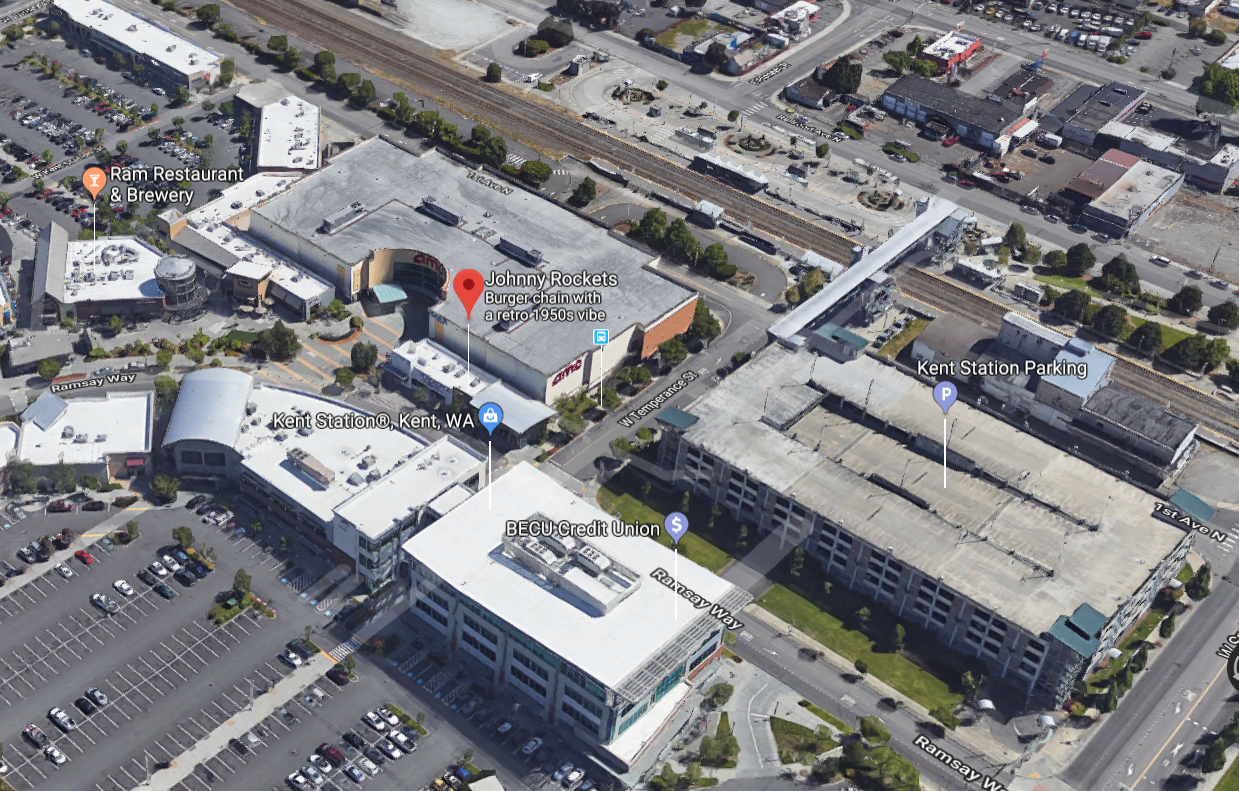
Finally I arrived in Kent and swung into Johnny Rockets for a burger and shake. After a ride like that it was supremely tasty.

kent.png

Kent… sort of. But WTF is Kent?

Here you can see in the photo above where Johnny Rockets is compared to the Kent Station Parking, BECJ Credit Union, more parking, some more parking, some other… oh gawd the disgusting myopia of suburban design with a wannabe town center mall thingy in the center.

Whatever I’ll move on. The train station is over there in the upper right here in the map 3d photo. It’s cool that the train station also has a pedestrian overpass from the station over to the… oh, the damned parking lot.

This is another example of extremely shameful design on so many levels. 50’s era myopia and the perverse irony is I go eat at the retro 50’s era burger joint. The more I look at the photo the more I’m sicked by the absurdity of Kent’s layout and design and I’m not even sure why they have a Sounder station when the area is clearly anti-pedestrian, anti-active transportation, and just about as auto-focused as one could get without pulling a sidewalk-less 50s’ era suburb out of the actual 50’s.

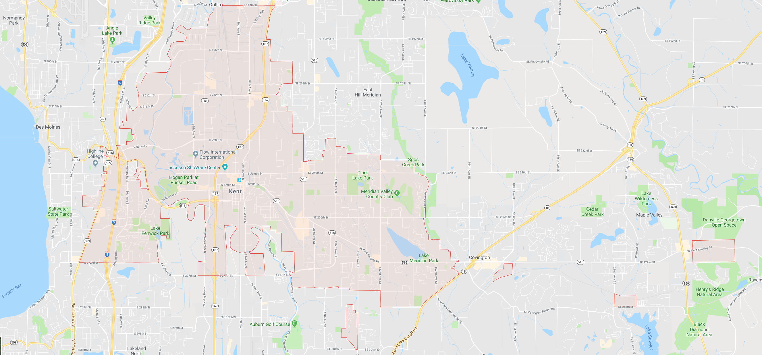
As I sat there and ate I looked into Kent’s history and related things more. The first thing I did was pull up a map that explained a lot of things about how Kent is laid out. Look at this city border.

kent-is-shaped-funny.png

A generally unmanageable, non-urban, tax sucking sprawl zone. What is it with those squares of Kent over there acting like islands even? What. the. … wow. Just wow, so much bad about this.

Alright, whew, I had to stop looking into Kent’s history and layout. Kent’s basically a living example of why city Government is burning this country to the ground right now in myopic, dystopian suburbanite hell while the feds are burning it up from every other direction. But enough of all those happy thoughts, onward to the trip home. I got some nice shots of the Sounder, coming south bound and north bound.

In the photos above, if you look closely you’ll notice that it’s actually two different train sets. On the departure of both it becomes obvious, as one set as the cab car without the facade of a crew cab that looks like an engine front. The other has the standard cab car that looks just like a regular passenger car.

After the two trains, which were train bunched (using the bus bunch term there for trains, generally I suppose the train is just “delayed”). The first of the two had a medical emergency, which I believed equated to someone getting sick and puking, so they got off at Tukwila after a quick clean up. Only about 16 minutes late – err, I mean delayed – whatever the wording is. So after that train, and the next just a mere 3 or 4 minutes later arrived and departed the north bound train, now delayed about 2 minutes, pulled into the station here. It was operating in push mode, which means the engine is pushing it from the rear.

I boarded and off we went. That’s when I started this somewhat long blog entry about the day. After a pleasantly uneventful ride of about ~30 minutes we pulled into King Street Station and I grabbed my bike and headed for the stop where I’d catch either the 40, or if I was timing it good enough, one of the 17x or 18x express buses. As I arrived at the bus stop, an 18x pulled up and I didn’t even have to stand and wait any. I just walked right up, after confirming with the driver of course, and mounted my bike. Jumped aboard, paid, and got one of the ideal front facing seats on the bus.

With the express it’s about a ~28 minute ride to downtown Ballard. Which is where I was heading. We left, and the trip went seamlessly along the bus dedicated lanes, and then off off 15th and under the bridge onto Leary. Minutes later I arrived in Ballard and wrapped up this adventure. It was a good trip overall, learned a few dozen things about Kent, didn’t get killed by a negligently errant motorist, enjoyed a lot of fresh air and a bit of exercise to boot. All that and the burger, train ride, and related items where a pleasant icing on the cake!

Until next trip, happy transiting!

Seattle Loses 17% of Transit Service

Ok, so it hasn’t happened yet. But as one would expect, more cuts are on the table. The Feds haven’t fixed the transit situation with funding options & the local cities & states just keep sucking money out into other solutions. It’s kind of par for the course. Seattle is threatened with a 17% loss in service. Most bus lines would lose one out of every bus. The only lines that would likely remain untouched would be a few of the Rapid Ride lines and high capacity runs during rush hour. But everything else is up for cutting.

What can you do about it as a citizen of Washington and Seattle? Go and message your elected leaders.

The US is seriously losing it’s ground right now, it’s happening fast. This is seriously getting interesting in some scary kinds of ways. Weigh in with your opinion, it may be the difference between standing in the cold, sitting in MORE traffic in Seattle or worse.