The Uncomfortable Truth(s) About Seattle’s Founding. However, these things you ought to know living in Seattle and if you’re curious about why things are the way they are here in Seattle.
Let’s talk about how Seattle got its start, because the story is both remarkable and deeply uncomfortable. In 1851, a group of white settlers—led by Arthur Denny, Carson Boren, and David “Doc” Maynard—landed at Alki Point. They were, to put it bluntly, exactly what you’d expect from mid-19th century European settlers: a bit bumbling, entitled, racist, and operating under the delusion that they had some divine right to land that had been occupied for thousands of years by the Duwamish people (and others in the surrounding area, cuz it didn’t just stop with the Duwamish).
Some of these settlers were essentially Christian thieves, showing up with their Bibles and their sense of superiority, ready to claim whatever they could get their hands on. David Denny, Arthur’s brother, was notably the more religious zealot among them, often finding himself in conflict with the other settlers over his strict religious convictions. They named their settlement “New York-Alki” (Alki meaning “by and by” in Chinook Jargon), which tells you everything you need to know about their ambitions and their complete disregard for the existing inhabitants.
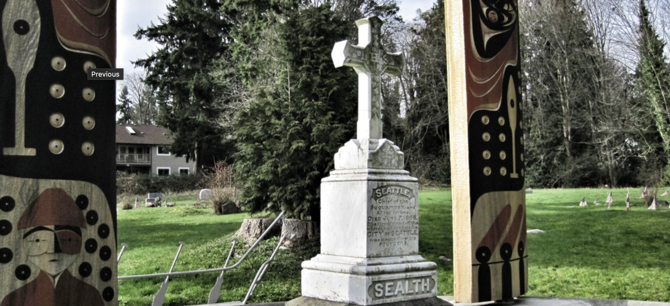
But here’s where the story takes a turn that these settlers probably didn’t deserve: Chief Sealth (anglicized as “Seattle”) of the Duwamish and Suquamish tribes didn’t just tolerate these interlopers—he actively helped them survive. Despite the settlers’ racism, despite their entitlement, despite their complete lack of respect for the land and its people, Chief Sealth extended grace and protection.
The settlers were struggling. They were unprepared, they were vulnerable, and they were in a land they didn’t understand. Chief Sealth could have let them fail. He could have driven them out. Instead, he chose a path of diplomacy and assistance, recognizing that conflict would only bring more suffering to his people. He negotiated treaties, provided food and knowledge, and essentially saved these settlers from their own incompetence.
It’s a story that should make us all uncomfortable. The man whose name would eventually grace the city was treated with less respect than he deserved, and the settlers who benefited from his generosity would go on to systematically displace and marginalize the very people who had saved them. The Duwamish people, despite Chief Sealth’s efforts, were pushed out of their ancestral lands, and to this day, the Duwamish Tribe remains federally unrecognized — a final insult in a long history of broken promises.
The Interurban: Seattle’s Early Growth Engine
Fast forward a few decades, and Seattle was starting to become something more than a frontier town. By the turn of the 20th century, the city was growing, but it was constrained by geography. The Puget Sound region is a weird place—mountains, water, and valleys creating natural barriers between communities. Everett to the north, Seattle in the middle, Tacoma to the south. These weren’t just separate cities; they were separated by geography that made connection difficult.
Enter the Interurban Railway. Starting in 1902, the Puget Sound Electric Railway began connecting these disparate communities. The line ran from Everett through Seattle and down to Tacoma—a 75-mile route that fundamentally changed how people lived and worked in the region.
This wasn’t just a train line; it was a growth mechanism. The Interurban made it possible for people to live in one city and work in another. It enabled the development of suburbs and satellite communities. It created economic corridors and allowed the region to function as a cohesive metropolitan area rather than isolated towns.
The Interurban ran through what would become some of the most important commercial and residential corridors in the region. Stations sprouted up along the route, and communities grew around them. The line carried commuters, freight, and mail. It was the backbone of regional development, and it ran on electricity cutting-edge technology for its time.
But here’s the thing about infrastructure: it requires maintenance, investment, and political will. By the 1930s, the automobile was becoming dominant, and the Interurban faced competition from highways and buses. The Great Depression hit, ridership declined, and the private companies running the service struggled. By 1939, the last Interurban train ran, and the tracks were torn up.
From Rails to Trails
The Interurban was gone, but the corridor it created remained. Over the decades, parts of the right-of-way were developed, but significant portions remained undeveloped. In the 1980s and 1990s, a movement began to convert these old rail corridors into trails—the Interurban Trail system.
Today, you can walk or bike along sections of the Interurban Trail, following roughly the same path that trains once traveled. It’s a nice amenity, but it’s also a reminder of what we lost. A trail is great for recreation, but it doesn’t move people at scale. It doesn’t enable the kind of regional connectivity that the Interurban once provided.
The Slow Return: Link 1 Line
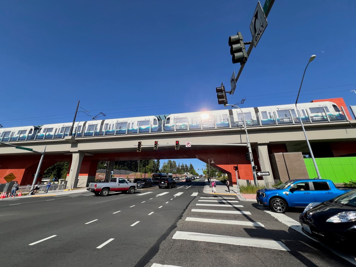
Now, decades after the Interurban was torn up, we’re slowly rebuilding what we destroyed. Albeit not on the original route, but connecting the same core cities. Sound Transit’s Link 1 Line is gradually extending north and south, following many of the same corridors that the Interurban once served. It’s a slow process—agonizingly slow for those of us who understand what’s possible—but it’s happening.
The Link 1 Line connects Everett to Seattle to Tacoma, just like the Interurban did over a century ago. It’s electric, just like the Interurban was. It’s serving the same function: enabling regional connectivity and acting as a growth mechanism for the area.
But here’s the difference: we’re spending billions of dollars and decades of time to rebuild something we already had. We’re learning lessons that were already learned a hundred years ago. We’re rediscovering that transit enables growth, that regional connectivity matters, and that electric rail can transform how a metropolitan area functions.
It’s progress, but it’s also a reminder of how short-sighted we can be. We tore up a regional rail system that was working, replaced it with highways and sprawl, and now we’re slowly piecing it back together at enormous cost.
The Legacy
Seattle’s story is one of contradictions. A city named after a chief who saved settlers who didn’t deserve his grace. A region that built world-class transit infrastructure, tore it up, and is now slowly rebuilding it. A place that understands the value of regional connectivity but took nearly a century to act on that understanding.
The Interurban was more than a train line — it was a growth mechanism that shaped the Puget Sound region. Its removal shaped the region too, just in ways we’re still dealing with: sprawl, traffic, and disconnected communities. The Link 1 Line is the slow, expensive correction to that mistake.
As we watch the Link 1 Line extend mile by mile, station by station, the city and people are not just building transit — we’re rediscovering what Chief Sealth and the Interurban already knew: that connection matters, that regional cooperation enables growth, and that sometimes the best path forward is to learn from the past, even when that past includes uncomfortable truths about who we are and how we got here.
Now, the story of the Chief and this line might not seem connected right now, but I wanted to detail these two topics as I’ll be referencing back to them in the coming days with a number of posts. Be sure to subscribe and you’ll get to read about the interconnected nature of it all!