Redmond and Bellevue, long synonymous with sprawling parking lots and endless highways, vertical spines of suburban hoity toity tasteless strip malls, are finally trying to shake off their addiction to the automobile. The new projects around 152nd Avenue NE, 156th Cycle Track, and Overlake Village Infrastructure are touted as the next big thing in making the area “livable”—because clearly, we’ve all been loving those car-infested corridors so much that it took decades to realize something was off. Here’s a look at the “ambitious” plans to reclaim some humanity from the asphalt wilderness.
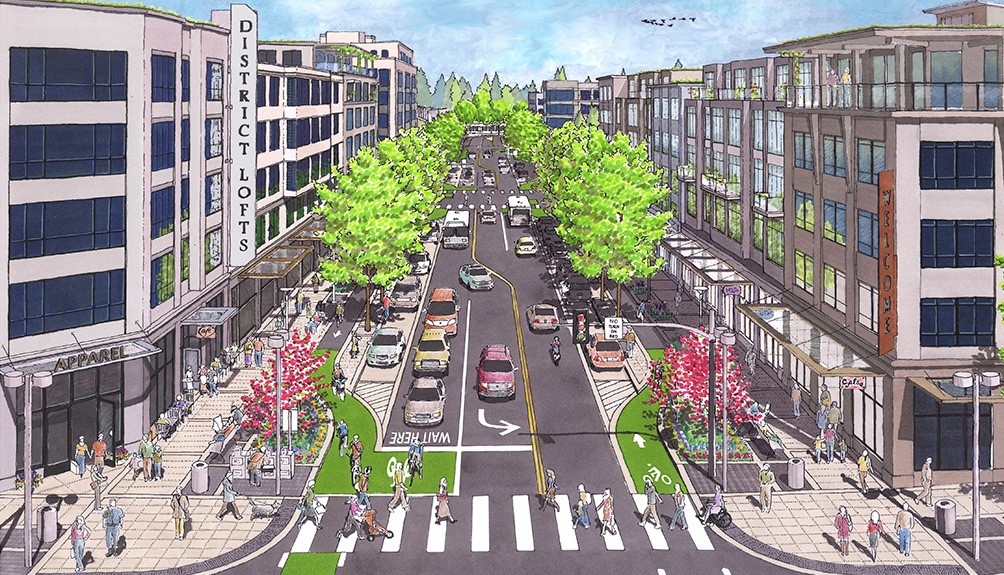
152nd Avenue NE Main Street: The Quest for a Pedestrian’s Paradise in Car-Land
The 152nd Avenue NE Main Street project aims to turn a once soul-crushing stretch of road into something “pedestrian-friendly.” Imagine that: walking down a street where you’re not just waiting for a crosswalk signal like it’s an act of divine mercy. This project will roll out wider sidewalks, because, surprise, people do actually walk, and protected bike lanes, because it turns out bikes aren’t just a relic of the past. In addition, they intend to put in place an actual street grid like a real city!
The city planners are throwing in some landscaping and public art—likely to distract us from the decades of prioritizing cars over community. And yes, we’ll get street lighting that’s more than just the sad, dim bulbs that currently light up the vast emptiness of parking lots. It’s a bold move to try and inject some vibrancy into a street where, up until now, “scenic” meant looking at the back of someone’s SUV.
156th Cycle Track: Because Cyclists Deserve Better than Dodging Cars
For the brave souls who dare to bike in a city built for cars, the 156th Cycle Track is the beacon of hope we’ve been waiting for—or at least, it’s supposed to be. This project is designed to give cyclists a protected road of their own in this segment, so they no longer have to rely on sheer willpower and the kindness of strangers motoring around in their cages to avoid becoming roadkill.
The cycle track will connect the SR 520 Trail to Overlake Village, finally giving cyclists a direct route that doesn’t involve navigating a gauntlet of speeding vehicles and poorly timed traffic lights. It’s almost like the city realized that people might choose bikes over cars if they didn’t fear for their lives. What a concept.
Overlake Village Infrastructure Planning: Patching Up the Auto-Dependent Mess
And then there’s the Overlake Village Infrastructure Planning—an initiative that sounds like it’s about fixing the glaring oversights of a car-centric past. This grand plan includes stormwater management (because, who knew, we need to deal with rain too), better transit access (since our existing bus stops on the side of highways aren’t exactly welcoming), and—wait for it—parks and green spaces. Because after all that asphalt, we could use a little green, right?
This plan is also about encouraging “transit-oriented development,” which is urban planner speak for “we messed up by spreading everything too far apart.” They’re now trying to fix it by building closer to transit hubs, a move that might finally give some residents the option to not drive everywhere—because clearly, parking lots as the centerpiece of community life didn’t turn out so well.
The Grim Reality: A Half-Hearted Attempt to Undo the Car-Centric Damage
These projects, despite their promises, can’t quite hide the fact that they’re desperately trying to undo decades of car-centric planning. The efforts to add pedestrian paths, bike lanes, and transit-oriented development feel a bit like putting a band-aid on a gaping gunshot wound, but hey, it’s better than nothing.
If you’re in the area, why not check out these efforts to bring some life back into the auto-dependent wasteland that we’ve built? Take a walk down 152nd Avenue, if you dare, or brave the cycle track. Maybe, just maybe, we’ll see the day when Redmond and Bellevue aren’t defined by their endless stretches of road, but by the vibrant, connected communities they’re trying so hard to become—one sidewalk and active transport corridor at a time!
Here are the key links to the projects mentioned in the blog post:
Back in April I took a trip to Pittsburgh, Pennsylvania. It is easily one of the best trips I’ve taken in a few years! Far too many years! Obviously I had to write up the adventure and that dear readers is what you have here, the log of my entire trip to Pittsburgh. I hope you enjoy following along with the adventure!
Along with the trip, which I’ll write details about here on this post and subsequent posts here on Transit Sleuth, another branch of posts will be on Vicious Shred concerning the record shops (Attic Records, etc) and music related peculiarities. So if you’re into the metal, and other varietals of music I partake upon, navigate over to Vicious Shred for a whole host of posts about that.
Day 1 – Departing Seattle via the Empire Builder
Day 1 involved departing Seattle. What did that involve? Well let me tell you!
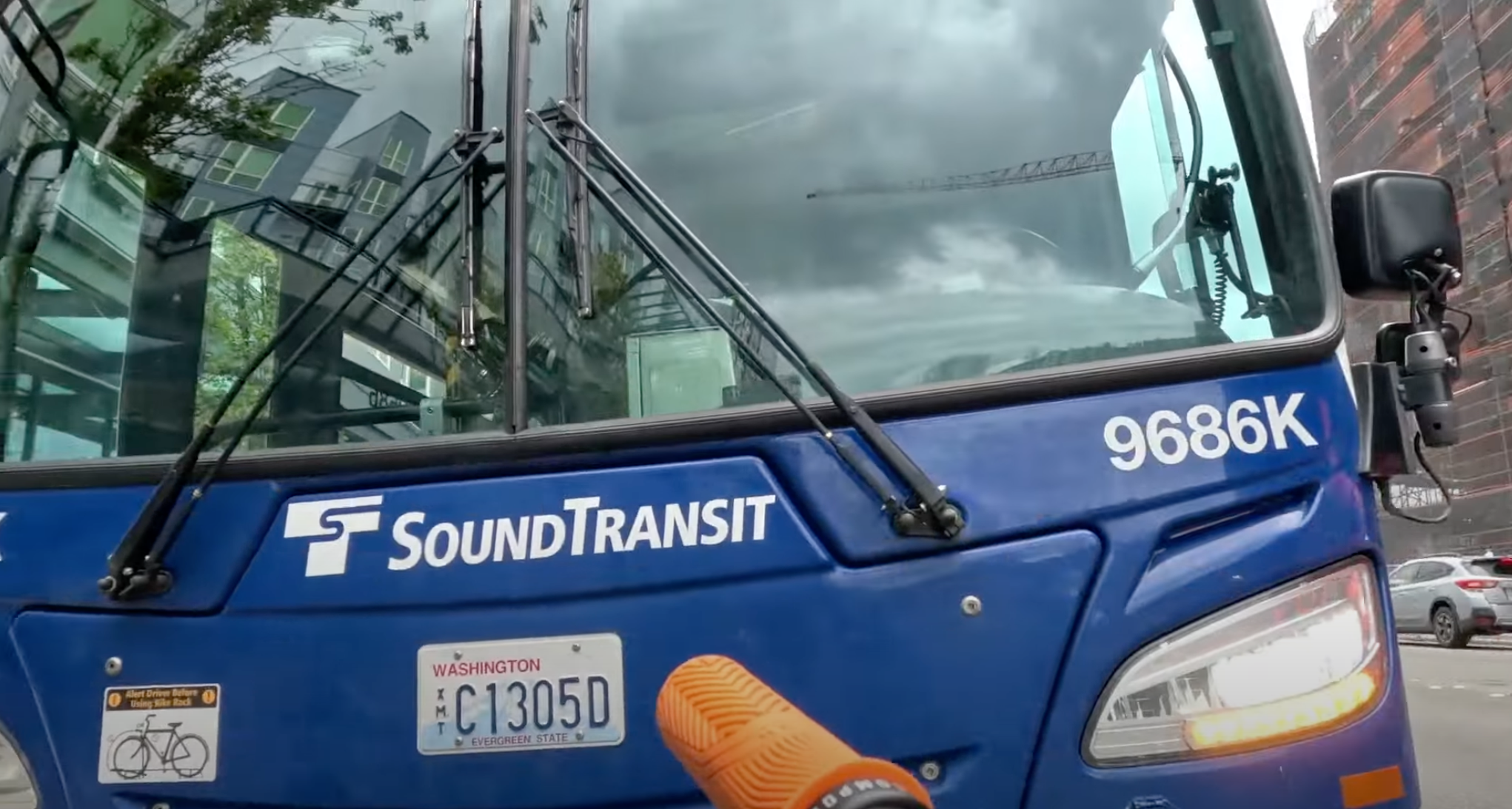
The very first event involved me biking down from home to downtown Redmond. There I caught the Sound Transit 545 out of Redmond heading to downtown Seattle & King Street Station. The bus arrived timely, I got the bike mounted up and off I went.
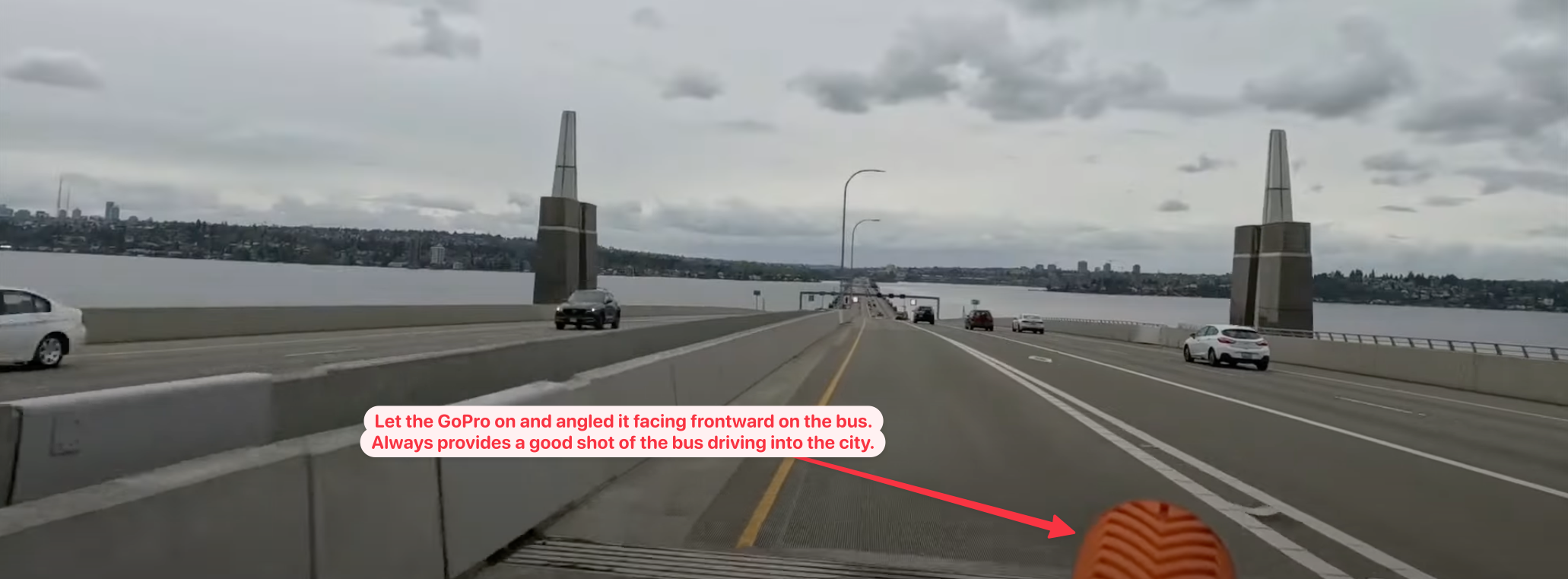
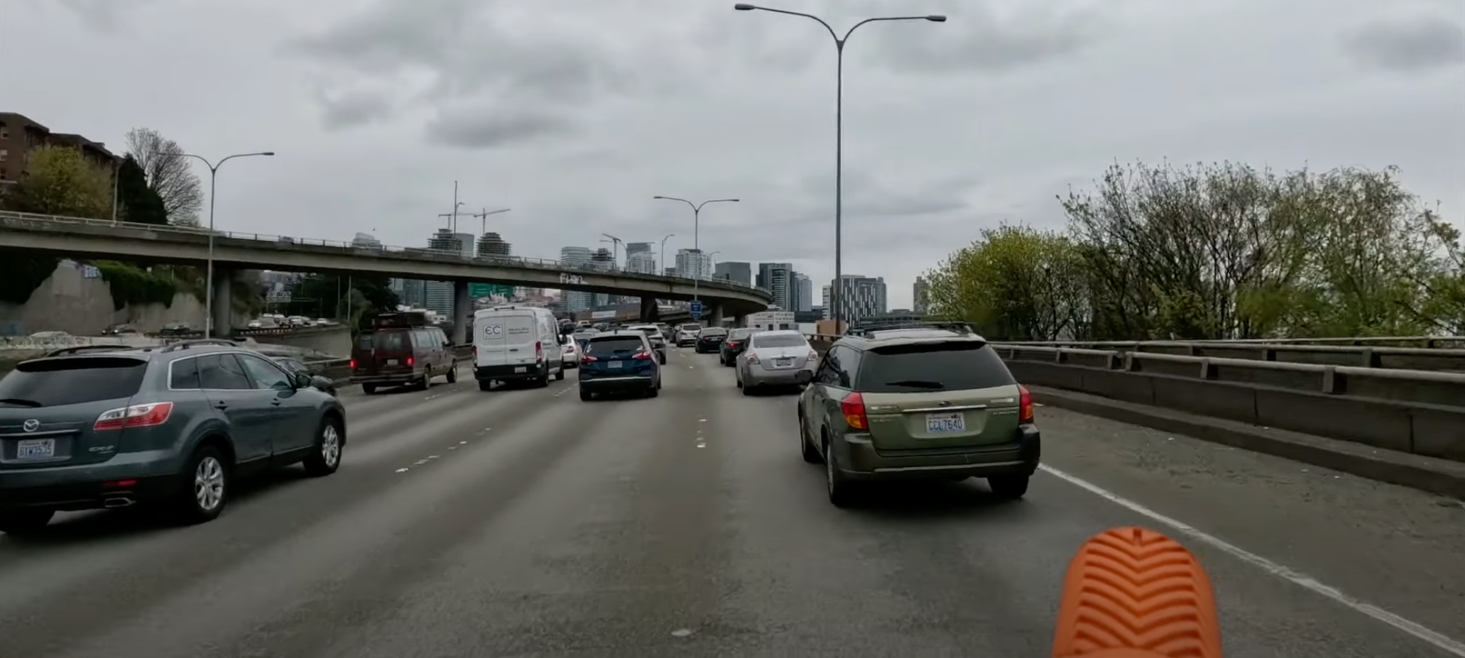
Shocker of shocker, as we got into the city there was a back up on 520 coming onto I-5, which is part of traveling on I-5. It’s always been backed up here and likely will always be. If someone is stupid enough to think they’ll resolve this poorly designed mess they don’t understand how cars work – and in that sense I am seriously looking forward to the day I can just on the tram (light rail) Link into the city!
Once I arrived downtown, I didn’t even attempt to ride the 545 all the way across the downtown core. There are two reasons I did got off the bus to travel this last few miles:
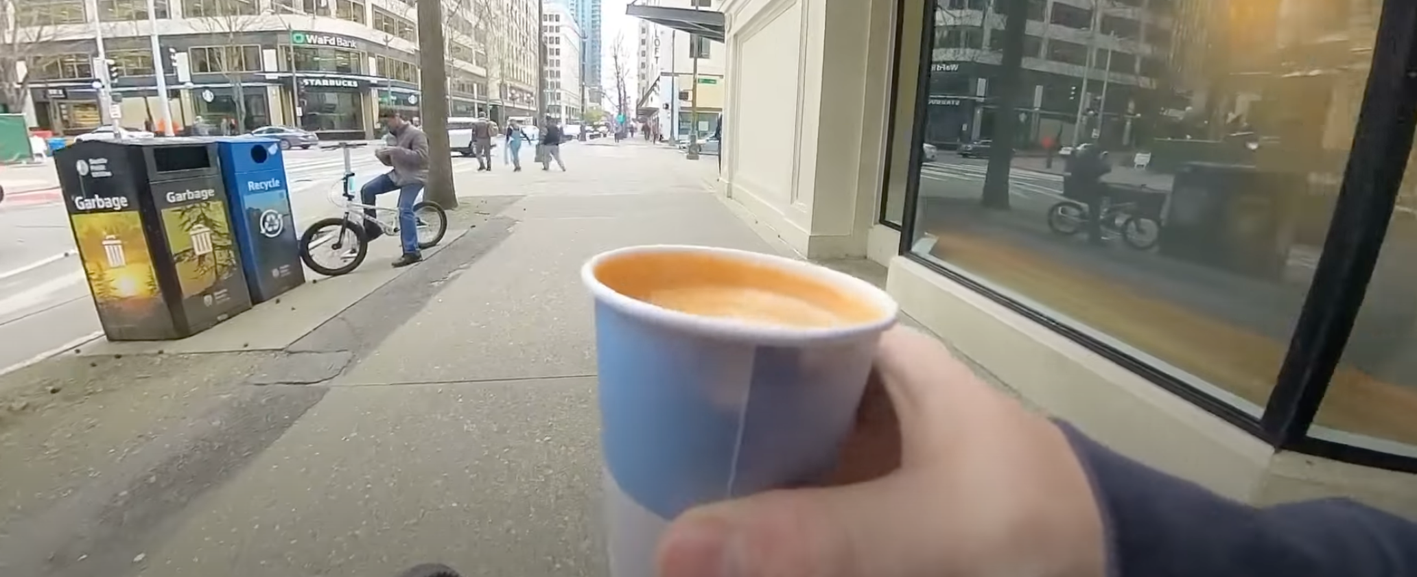
The main reason is I like to, as I’ve made it a tradition, to always stop at Monorail Coffee and get a cap before departure. For many – if not most – destinations in the United States it is likely the last time I’ll get a decent cap until returning. The espresso standards in the USA have improved to a degree so it isn’t as frequent I go without as it used to be, but I still don’t trust most cities.
The other reason is I actually like to ride through the city – I love cities, love em’! Some folks don’t get that from me but I see so much more than the mere concrete and fumbling crushed souls of the city and more the wealth generating heartbeat of America that US cities actually are. Albeit they’re severely damaged and have a severe quality of life issue compared to European cities. Largely evident in the vast warped subsidized American socialism experiment gone awry called “the suburbs”. But hey, they’re holding together the country in spite of all that!
Anarchist Jurisdiction
As the “Dear Leader” designated our poor fair destroyed obliterated city of Seattle, it is indeed destroyed y’all! Nobody come to Seattle, look at all that smoke and fire and burning, nobody is left! It’s all zombies and those lost in the riots. /s
Comedy aside, the ride through Seattle was rather pleasant. The roll – emphasis on roll because it takes almost no energy to pedal downhill from Monorail Coffee down to the train station – to King Street Station was smooth and effortless.
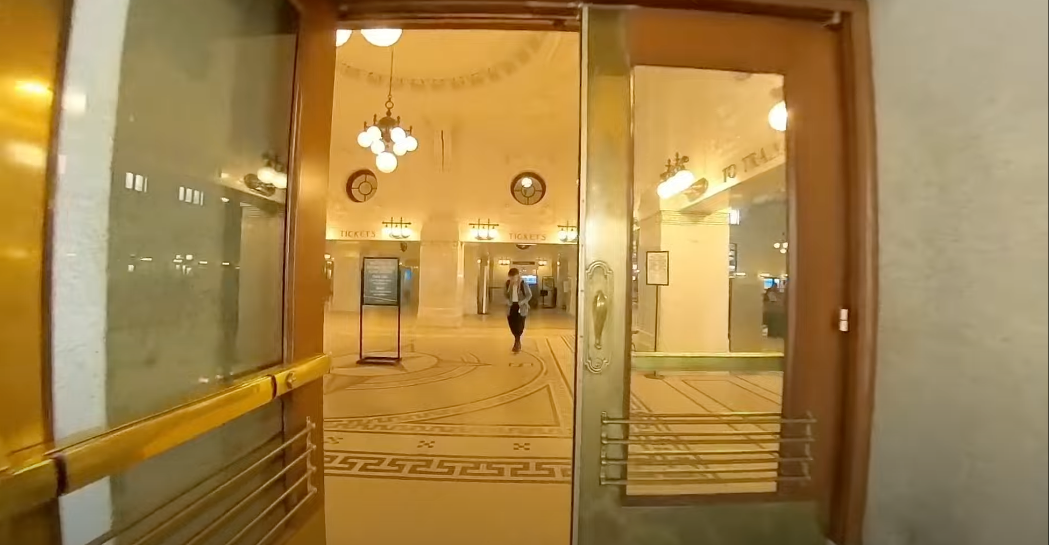
King Street Station
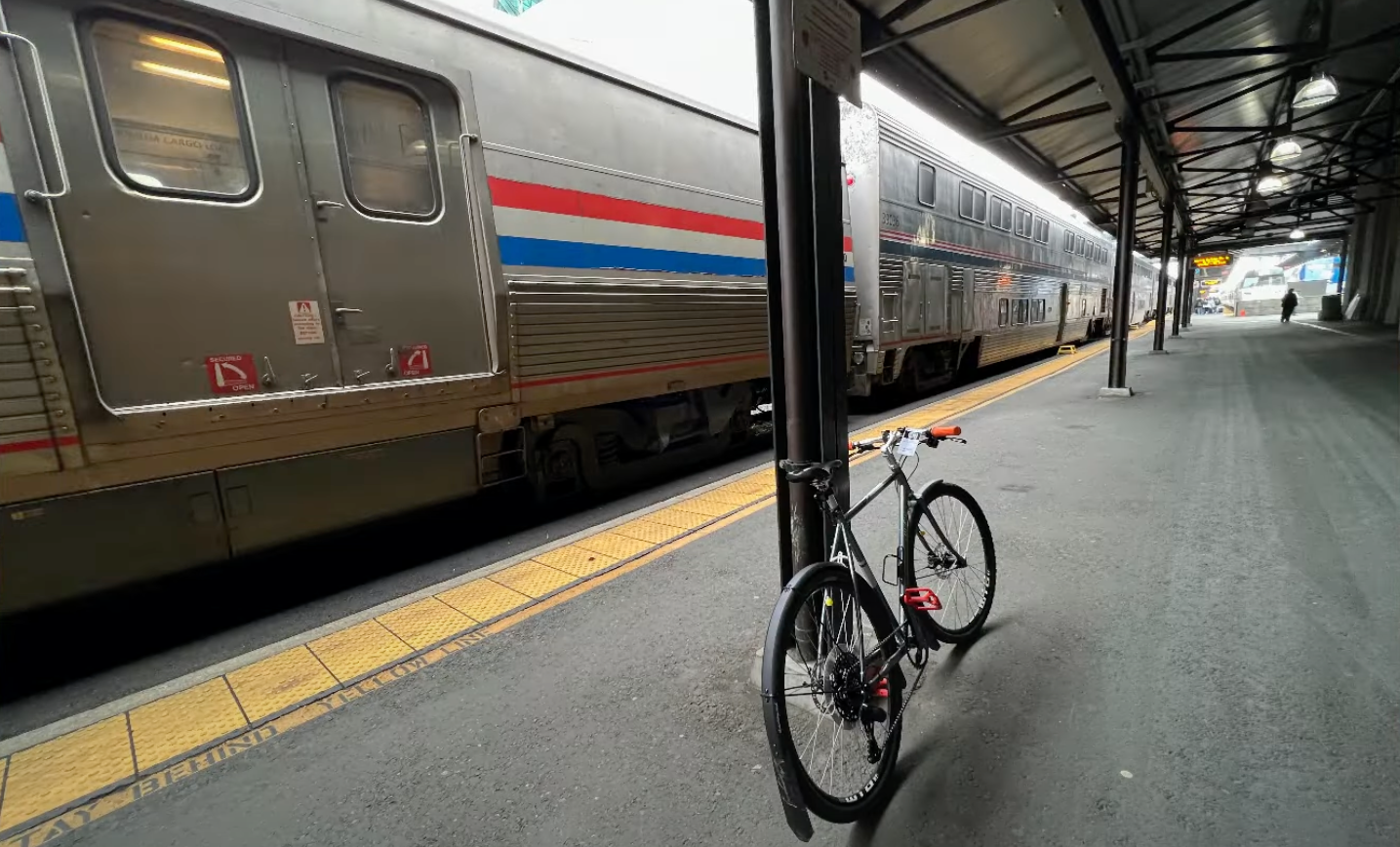
I arrived, got my bike tagged for the trip and headed off to the baggage car to hand off my bike. The only two things I brought with me was my Mission Workshop ARKIV Backpack and the bike (bounce back tothis post for details on why she’s named “PDX Orange”).
Tragedy Struck!
Chubby DOWN!!! You’ll have to watch the video for that bit of tragedy (time point @ the tragedy), it was already too much to write about the remnants of the destroyed city of Seattle! So with that bit of narration lagniappe, enjoy the video.
My Pittsburgh Adventure day 1 departing Seattle via King Street Station on the Empire Builder!
Day 2 – Eating on the Empire Builder
Day 2 can be summarized as eating day. There isn’t a lot to see or do on day 2, so it’s 3 meals and complete uninterrupted relaxation. In all seriousness it is one of my favorite days of the trip – even with the somewhat boring scenery – because I just do nothing. Maybe read, but mostly just thinking and introspecting against a repeating scenery. With that, I detail some of day 2 via VLOG for you dear reader!
Train Life, Day 2 on the Empire Builder from Seattle to Chicago, en route to Pittsburgh.
Day 3 – Empire Builder Transfer to Capitol Limited in Chicago
When I got into day 3, Chicago was the central action of the day. I needed to arrive on time or close to on time in order to make my connection to the Capitol Limited. The Capitol Limited route runs from Chicago to Washington DC. It makes a bunch of stops but my stop would be around 5:23am in the morning in Pittsburgh. If I had my preference, I’d have take another train that would have had me arriving in Pittsburgh at a more reasonable hour, but this being America we have a severe lack of transportation options between major cities!
The great thing about – in my humble opinion – coming into Chicago is getting into the urban fabric and watching the urban core and its skyscrapers start to rise out of nothing. If you’re privy, you get to see a lot of history as you roll into the city too. If you find that kind of thing fascinating Chicago is a city worth looking into.
In this episode I wrap up things by showing the path and process – for my brave fellow cyclists out there – of getting your bike stowed in Union Station. If you’re in the sleeper or 1st class like I was, you get to hang out in the awesome lounge at Chicago but you need to stow your bike in the meantime.
Pittsburgh Adventure Day 3 – Part 1 – Arrival in Chicago & wondering around Union Station.
In the 2nd part of day 3, transferring in Chicago I provide a tour of the 1st Class Lounge and then wander aimlessly around Chicago for a short while. Then I show boarding, which is a bit of an adventure in fumbling since I have a bike. Even though this is actually an easy process, you need to stay on top of things in order to make sure the bike does end up where you end up. Follow along in the VLOG to see more of the chaotic fun as I wrap up the Chicago transfer to the Capitol Limited!
Pittsburgh Adventure Day 3 – Part 2 – Transferring in Chicago & wondering outside Union Station.
That’s it for the Empire Builder part of the trip, in my next post I’ll delve into arrival day in Pittsburgh and the ongoing adventures!
I’ve given myself another transit and biking mission in addition to the upcoming posts on the Pittsburgh “Record Recon” missions. Find and recon the record stores in the Seattle “metro” area (obviously right, because I live here!). That includes a lot of territory and I’ll break down with maps and logistics where each of these record stores are and in the coming weeks I’ll be producing a series of videos on each of these shops.
The “Eastside” of the Seattle “Metro”. (Click for larger viewable map)
Now if you’re more interested in just reading about my music collections, reactions to new music, reviews, and all that then check out Vicious Shred. Between that blog and this blog, I try to segment my music specific things from my transit, transportation, and traveling adventures. With that said let’s roll on the record recon!
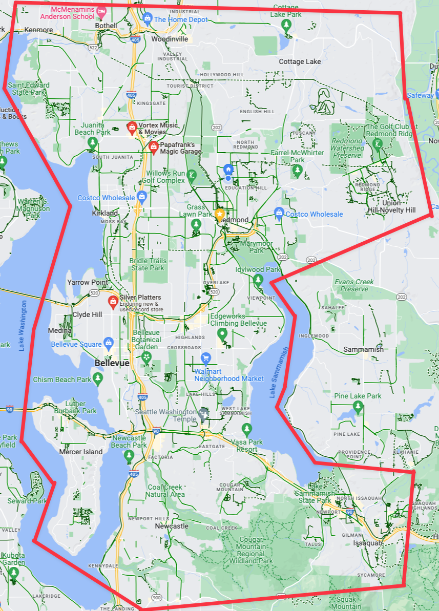
The Eastside (Seattle “Metro Area”)
Bellevue, Redmond, and the east side in general. This includes the area in the giant pink area. One could generally say “the area between the two major lakes of the area and the wooded northwestern lands of Redmond and Woodinville”. Not that a lot of that area is relevant because the east side simply does NOT have many record stores. However, there are a few, as you can see, which we’ll dive into.
The three record stores (garages?) on the “Eastside”. (Click for larger viewable map)
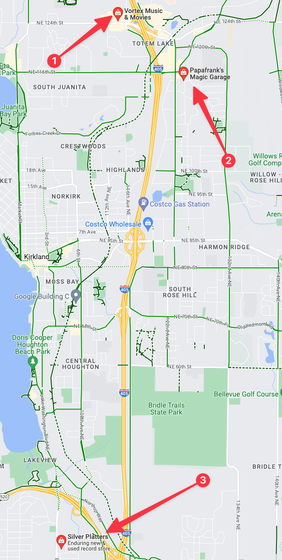
If we zoom in on the available record stores for the east side they’re all in two places, one is in north Bellevue and the others are in the Totem Lake area. There are only two efficient ways to get to these two area: 1 drive to either of them or 2 bike to either of the locations. Neither are walkable without multiple hours of free time to get to and from them unless you’re located directly inside of these specific areas. Fortunately in *these* suburbs I’ve got some excellent bike route options to get to both locations.
The second option, “Frank’s Garage” is literally Frank’s garage located in a suburban single family home off of any commercial corridor. This is super cool, but also I’ve noted that Frank’s “store hours” are only 1-5pm on Sunday. So that might have to get nixed if I can’t make this trip on a Sunday.
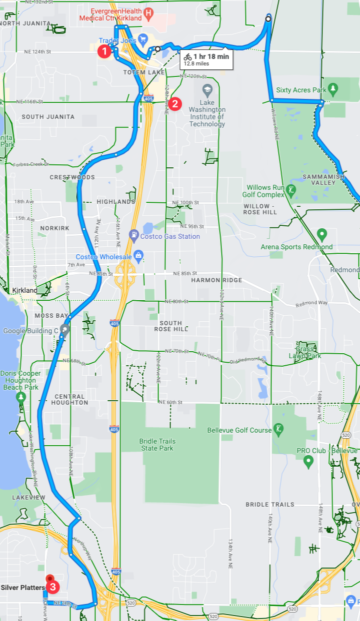
A key bike route is along the Cross Kirkland Corridor, which perfectly maps to nearby locations of all three of the record stores! This means that I theoretically could visit each of the record stores in one trip, efficiently stringing them all together in one voyage! Note that time, I’m going to set myself some specific challenges for this voyage:
Ensure the trip time is less than 1 hour and 18 minutes. Think I can accomplish that? I’m pretty confident I can beat that.
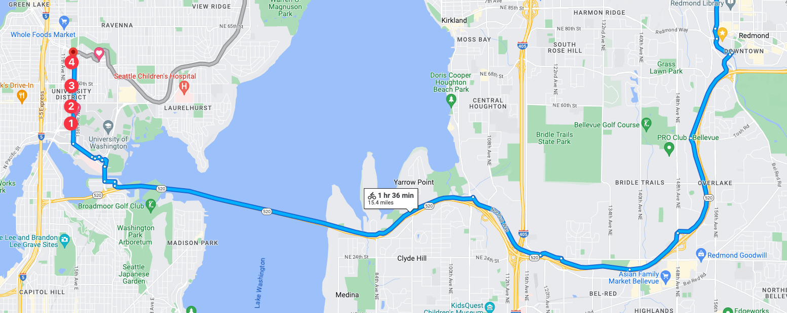
Check out both “Vortex Movies & Music” and “Silver Platters“, and for this first voyage to Eastside record stores I’m going to skip Frank’s since I can’t make a Sunday trip.
With that, this I’ll dub “Mission 1: Seattle Metro Eastside Record Stores Voyage“. But with the Eastside locations covered, let’s move on to the *actual* Seattle record stores.
Seattle (The actual *city*)
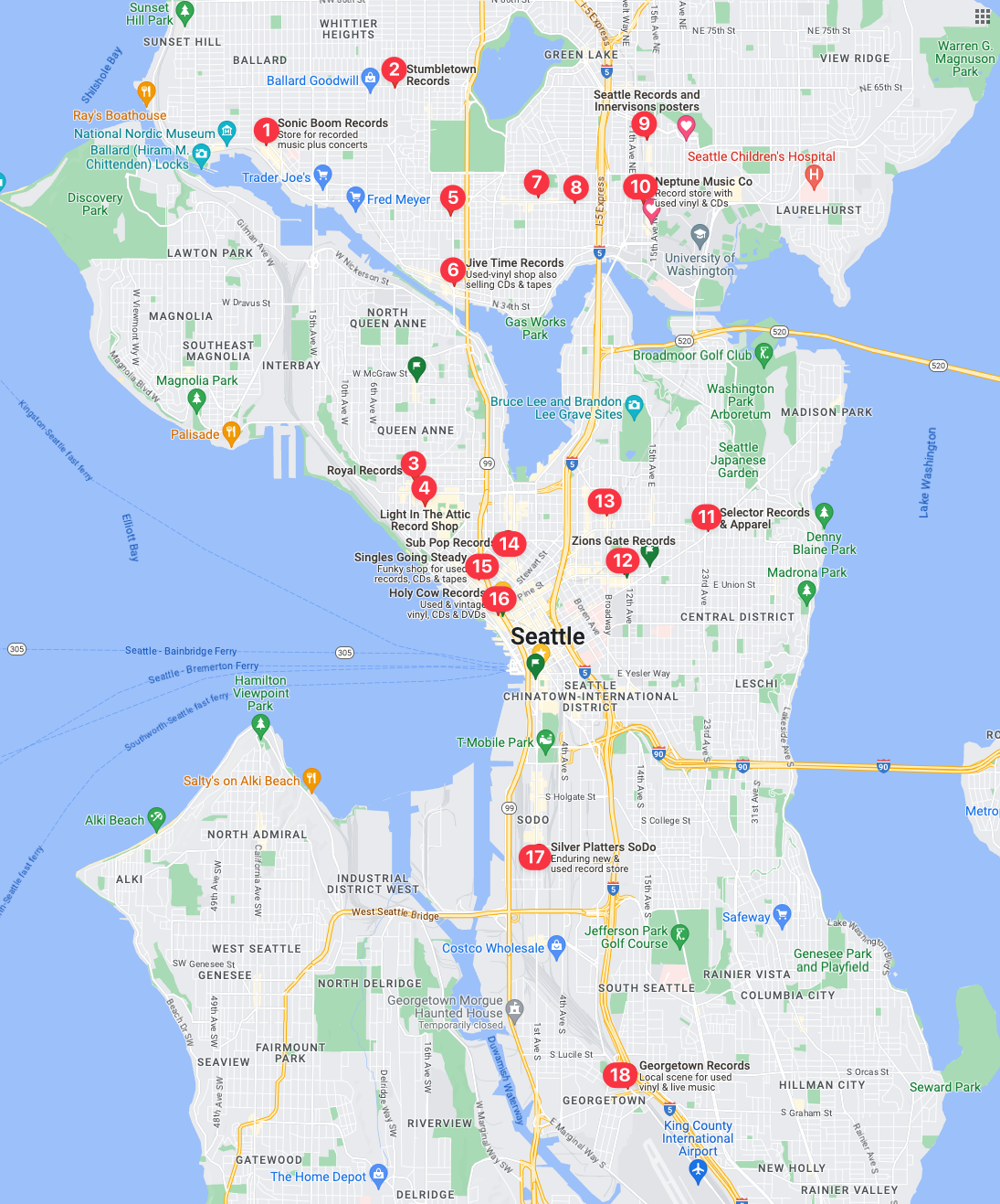
18 Record Shops – That come back in a maps query. There could be more, and if I zoom in…
My first observation, is that there are none in West Seattle, which seems really odd. I’m finding it hard to believe there isn’t a record store over there, as I’m 100% positive that Easy Street Records & Cafe is over there. Which, I’ll get over there for a full review in the coming weeks as it is easily one of the best record shops in the country let alone Seattle.
I’ve done a secondary query and there is indeed multiple record shops that don’t show up in the above, with the addition of Easy Street Records & Cafe showing up in a query of just West Seattle. Then I did another deeper zoomed map query of University District and sure enough, several additional record shops showed up: Neptune Music, Hi Fi Lo Fi, and Al’s Music, Video, & Games in addition to the two shown on the map above.
This is going to be multiple missions compared to the Eastside, as there is no single route that would travel through all of the record stores as there are just too many of them. But with a bit of study and logistical prowess I’ve attained from years of cycling all over Seattle, I’ve got a few plans following a few strategies.
With those extra queries, the 18 record stores in the map turn into 22 stores in Seattle proper! Clearly, if you’re into vinyl and live in Seattle you’d never have to leave the city, it appears Seattle has record store coverage almost everywhere! With 18 stores I’m going to guess I can maybe drop into 3-6 stores per trip, but it could very well be just 2 or more depending on which ones I’m aiming for. Based on routes and clusters of record stores here is the first two that I’ve deemed a priority.
Mission 2
Mission 2 record reconnaissance will be into the University District of Seattle with a goal to visit 4 stores: Neptune Music, Hi Fi Lo Fi, Seattle Records and Innervisions Posters, and Al’s Music, Video, & Games. There is another store that has theoretically opened at 6215 Roosevelt Way NE called Satisfaction Records & CDs that I’ll roll into this mission. It was in Ballard, but as I searched through the characteristics of that mission I had to back track and add it to this mission! Thus, it’s very likely this will be a recon mission with 5 stores!
Mission 3
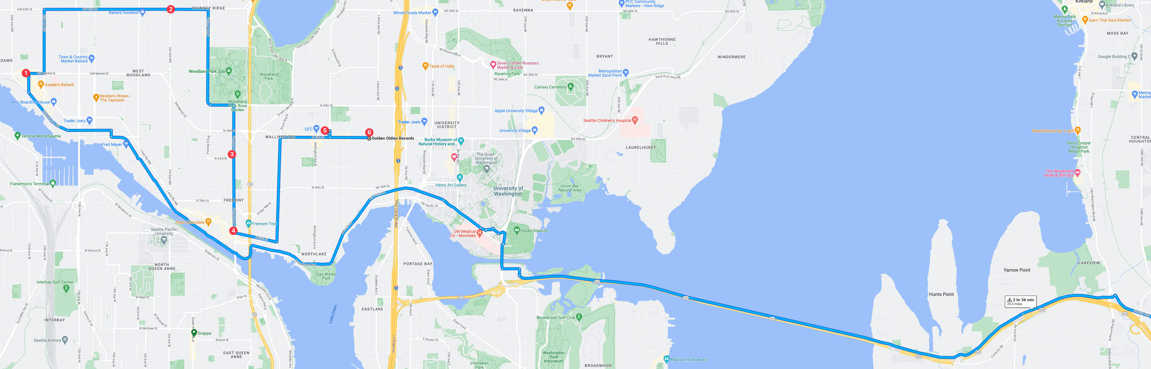
Mission 3 record reconnaissance will be into a trio of neighborhood areas: Wallingford, Fremont, and Ballard. This is extremely familiar territory since not long ago I lived in Ballard and also long ago I lived in Ballard. This reconnaissance run will be the hardest to date at this point with 6 record stores to visit! Will resources be enough? Will time be available? Will the store open hours be enough? It could be tricky but I think I can pull off 6 stores in one trip!
Overall, this mission holds a special place in my heart and mind as it’s in old stomping grounds of 2022 and before! In many ways I do miss Ballard and wish we could have stayed in the neighborhood but alas, to the east we went. But just before we left, one of the old well known record stores closed, which this trip will be a hats off homage to the long years of service of said store – if you know you know. But either way, this trip is gonna be fun to record and fun to log the visits afterwards.
Mission 4
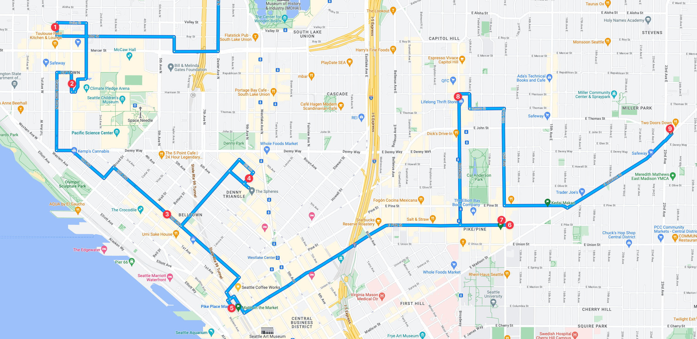
Mission 4 is going to be intense, and I might have to split it in two considering the 9 record stores to recon! I like to spend at minimum 15 minutes checking them out which would put just the time in store at 135 minutes minimum, but likely will be more if even one of. the stores has a great selection that I need to recon more intensely. My personal estimate with that many stores, it would add at least 3 hours or more to the entire recon mission just based on in store time.
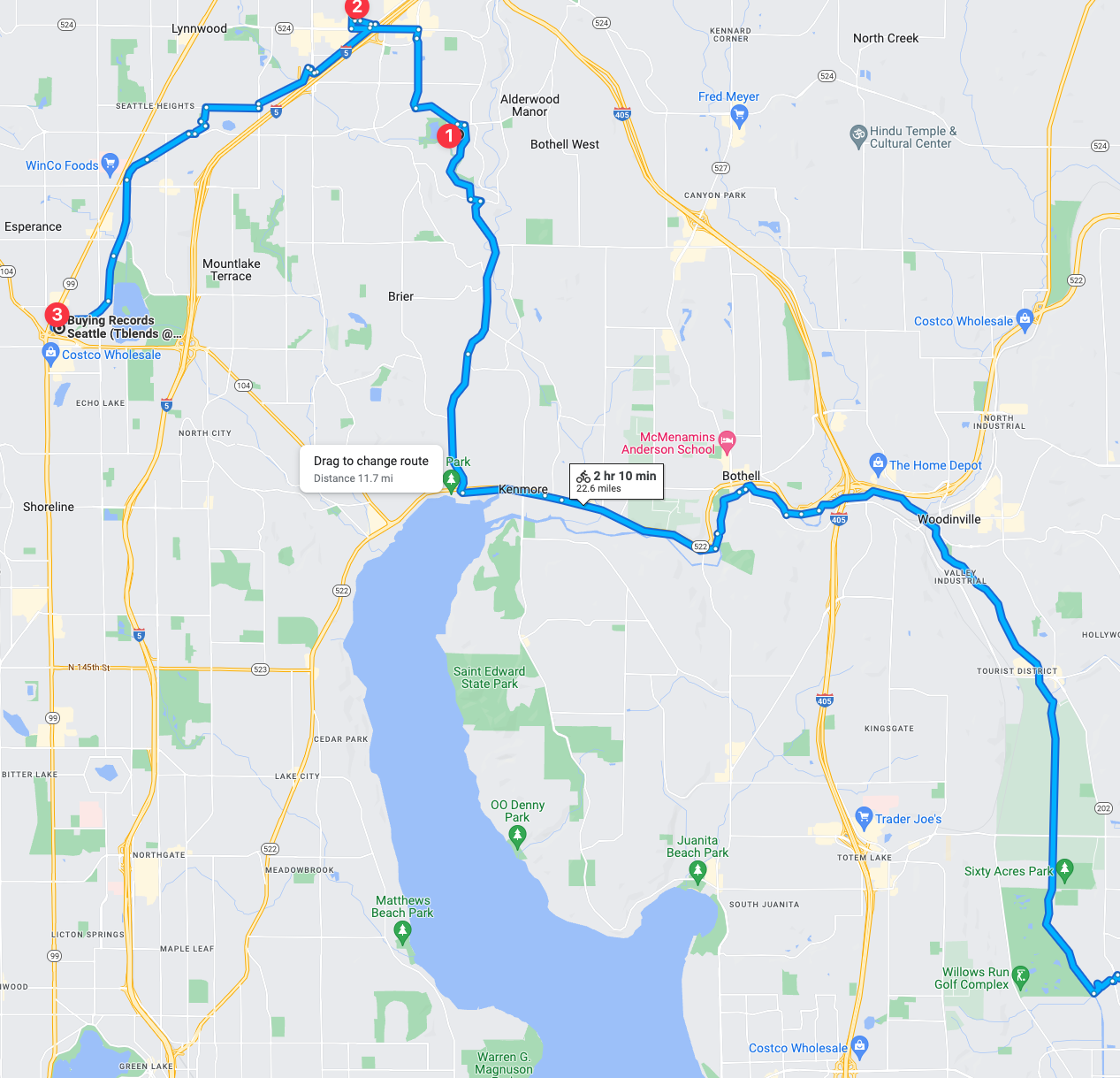
Mission 5
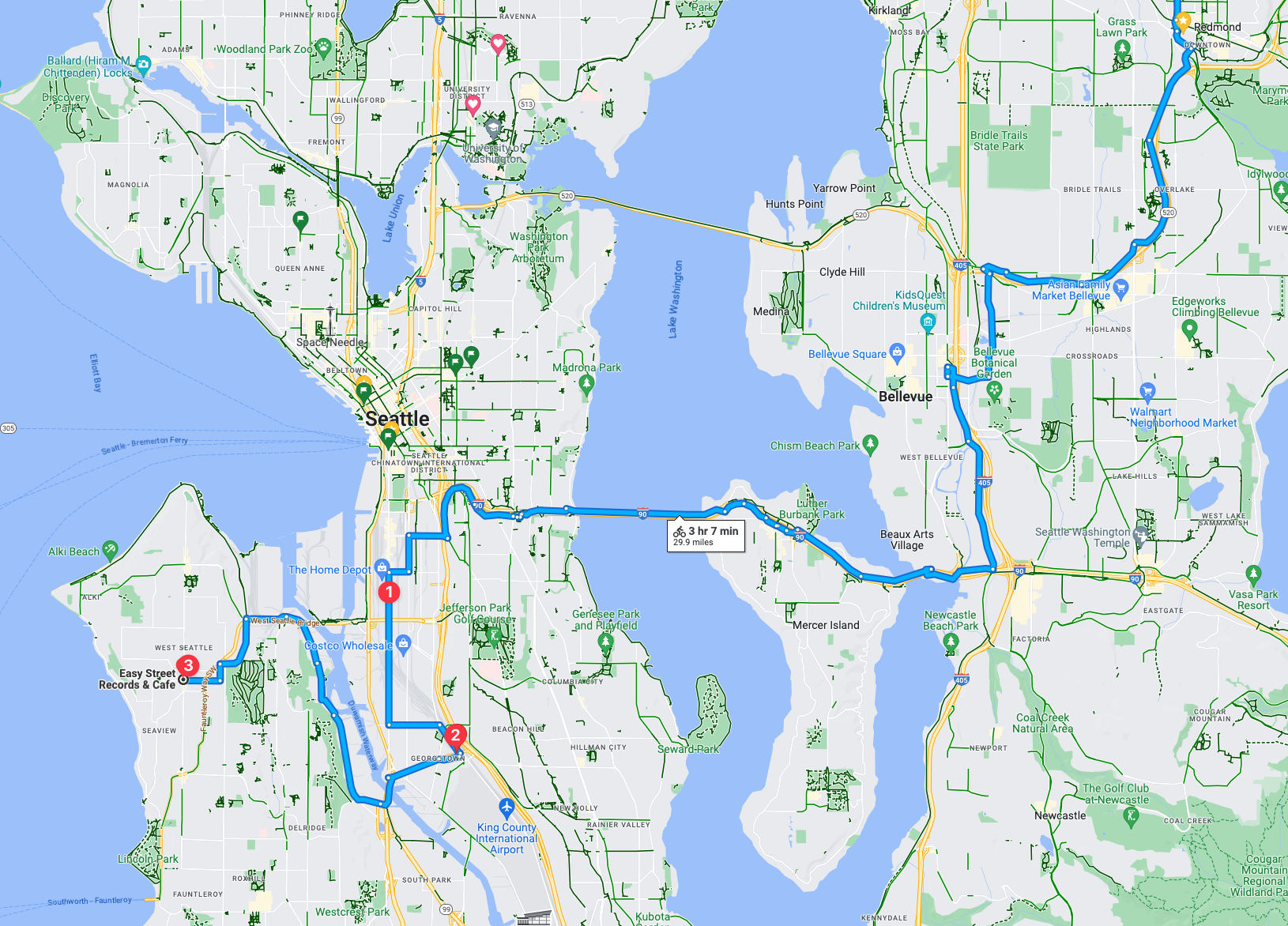
This mission will include a nice trip, albeit long at 3 hours and 7 minutes, it’ll be beautiful ride and an absolute shit ride. This recon trip includes three record stores. One being the Silver Platters SODO location should be pretty good. Then followed with what I understand (and know) to be two of the coolest parts of the city with two a respective awesome record store in each neighborhood.
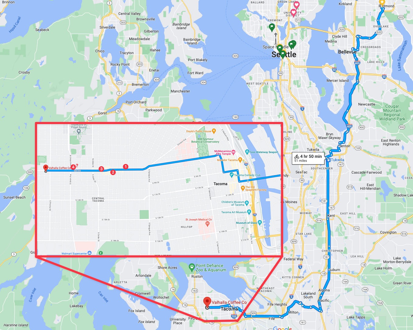
Tacoma (Not Seattle, but I had to include it!)
Mission 6
Mission 6 could be so intense from a trip distance, I might just need to interject a train into the mix! After all, trains leave from downtown Seattle and go straight into Tacoma, which would make this trip exponentially easier! But when the mission is on the calendar I’ll narrow it down and confirm the logistics.
Mission 7
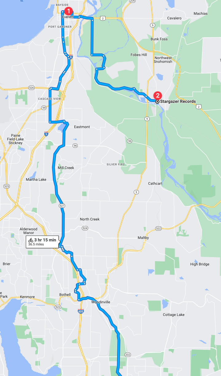
Seattle “Metro Area” North is a string areas north of Seattle and south of Everett. I’d go into detail but it’s unnecessarily complicated. Suffice it to say, this trip is going to be long at a suggested 2 hours and 9 minutes, with a significant amount of the trip via trails, amazing. There is still about 15-25% that is on roadway “bike infrastructure” which, in this area, translates to shitty car sewer stroads. But I’ll make due, this is going to be a very interesting recon trip. It’ll also be really interesting if the record stores will validate the trip effort! Hopefully there is a jackpot or two to find among the two.
The other thing that isn’t immediately noticeable in this trip is how much of the trip is actually dedicated trails! There are of course some roadways but significant portion of the trip is extensive trail routes! I’m really looking forward to that aspect of the trip.
Mission 8
In mission 8 the route is about 50% trail and 50% car sewers so that is going to be a bit of a challenge. Either or though, at some point I intend to complete this mission! These two stores seem fascinating and could be interesting collections unto themselves.
☑️ Mission 1: Seattle Metro Eastside Record Stores Record Recon
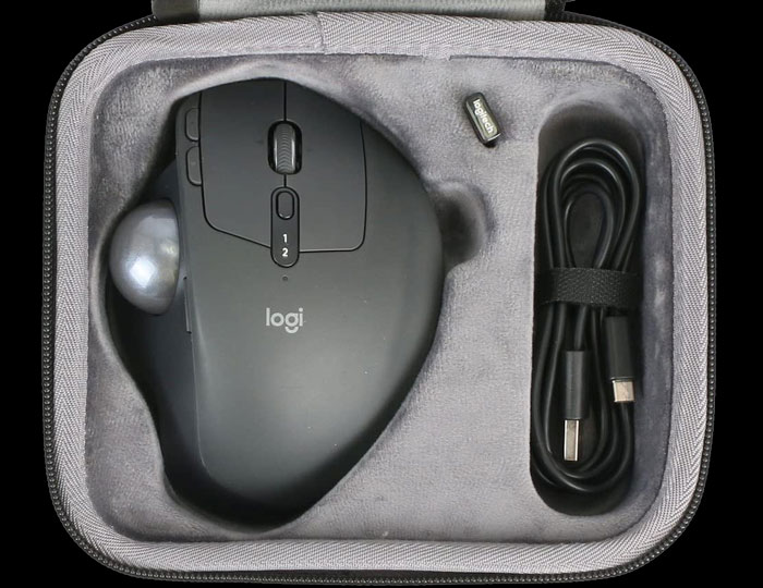
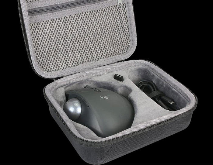
Recently I purchased a trackball and a hardshell case for that trackball, which I then wrote a review of over yonder “A Review of the MX Ergo Advanced Wireless“. The hardshell case primarily because I displace a lot during the course of the day. Whether traveling far away from home or just within the city in which I live (i.e. Seattle these days, but in the past Portland, Memphis, Jacksonville, New Orleans, Krakow, etc) it’s been very important to have computer gear that holds up well to these movements during the day. Here is a video that details the trackball, hardshell case, and some of the different places I’ve used it since purchase. Below the video I elaborate on two of the scenarios I use these devices.
Trackball Travels
Coffee Shop Cycling Displacements
Often during the day, at least a non-pandemic day, I work coffee shop to coffee shop. Meeting other coders, working alone, or having meetings in person in coffee shops. As I move from coffee shop to coffee shop, sometimes I use transit (bus/train/tram/streetcar/etc) but more often I bike from shop to shop. During these displacements computer gear can get banged up heavily. That’s where the hardshell case for the trackball is hugely important!
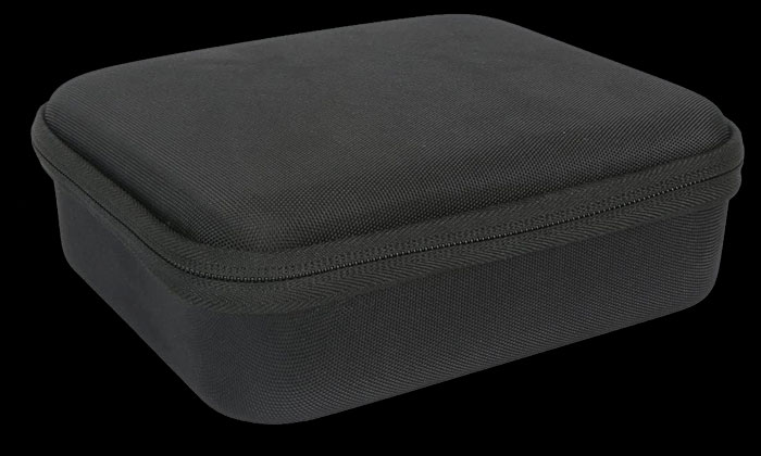
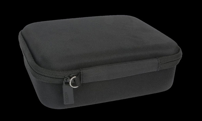
Here are some detailed “product” shots from Amazon/co2CREA, and the link itself to the product if you want to pick it up.
The Hardshell Case from co2CREA
While cycling all sorts of things can happen. I could biff it (i.e. *wreck*) on my pack (i.e. messenger bag, or backpack) and things are safe from direct impact in there, but can still be squished. I could toss my bag down or set it somewhere and it gets kicked, hit, or falls. The number of impact scenarios are numerous. But it doesn’t stop there while out cycling, since most of my packs are waterproof it’s nice to have individual elements packed in water resistant packages for when I pull them out of their pack. You get the idea, there’s a lot of potential oops scenarios, and for maximum gear lifespan it’s best to keep them safe.
Railroading Baggage Pannier Packing Style
Alright, using panniers for bike and train combo trips is another one of my specialties. I take a lot of train trips. Sometimes I ride coach, sometimes I get a roomette or bedroom, and on some trains I may end up standing. Whatever the case, traveling means luggage of some sort and luggage gets banged around. Again I’ve got my packs, but also in this scenario I routinely use my panniers. The combination is great as the survivability of devices – Apple Laptop + hardshell case for pointing device plus tough packs with panniers holding the remainder of things means surviving insane things like train wrecks (i.e. my experience of the train wreck of 501), or just regular travel trips like my trips to San Francisco for QCon, or my trip to Olympia, Washington to speak at a users’ group.
In summary, if you want to enjoy the bikey life combo powered with the rail life and keep your gear intact, it’s a good idea to pick up a hardshell case.
Ever since I moved to Seattle some years back, I’ve ridden all over the city pretty much all the time, any weather, by bike. But even amidst all this riding combined with tons of requisite hill climbing, I do enjoy cheating a hill climb every now and again. These are some of the ways I do this, and a giant thanks to KC Metro and Sound Transit for providing solid, reliable, and kick ass services to be able to pull off these hill cheats!
Capitol & First Hill Cheats
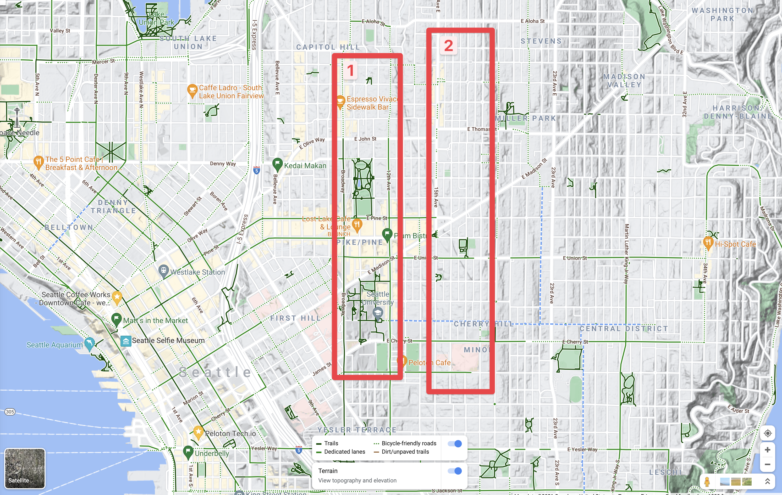
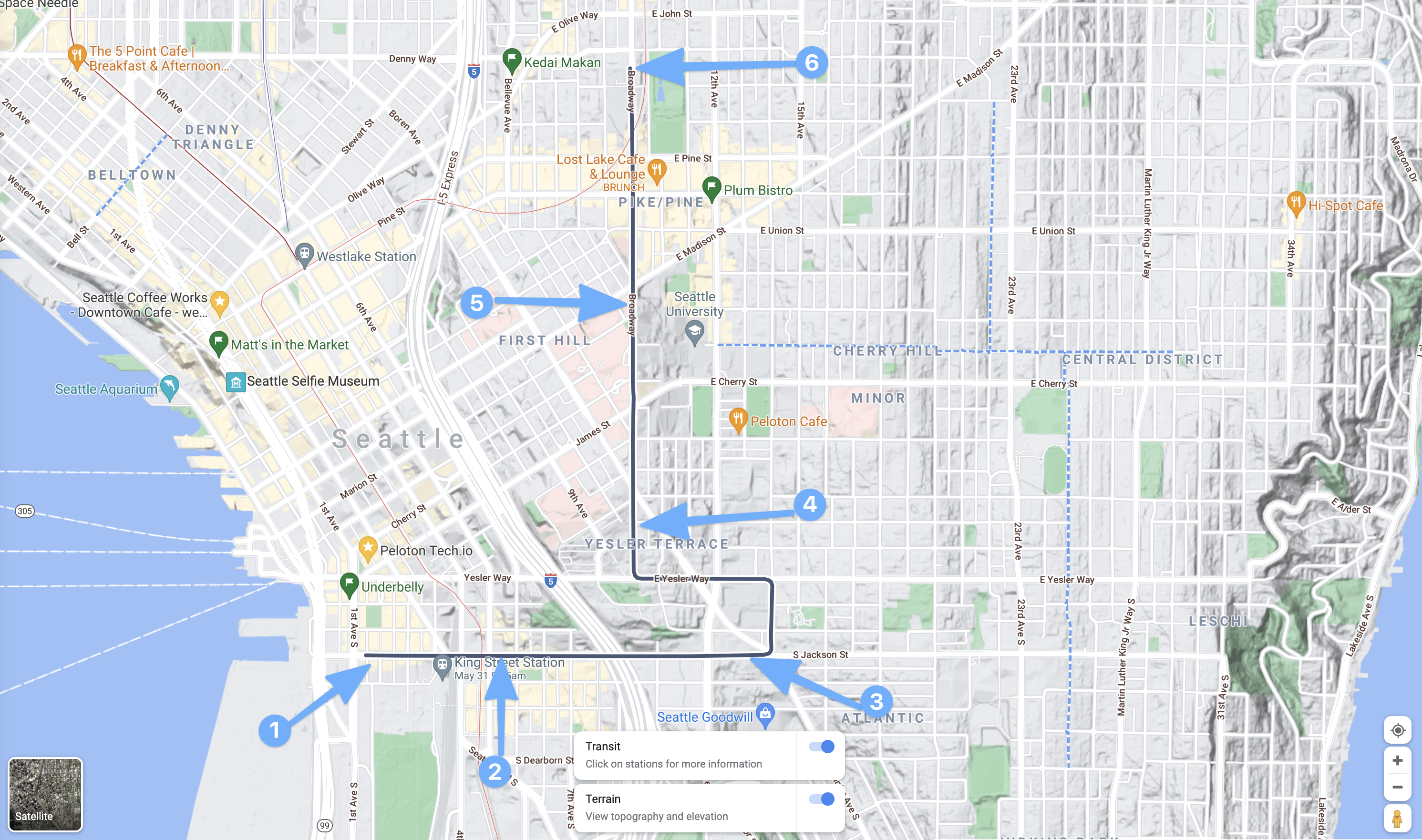
The easiest ways when riding to get up to the top of Capitol or First Hill, or mostly to the top of Capitol or First Hill, is to use the LINK, and secondarily the Capitol Hill Streetcar (which is by no means fast, but it’s real easy). The reason I bring up these two modes as the easiest, is because you can just roll on and roll off with a bike. No need to rack anything or go to any trouble, just on and off, with an ORCA swipe off of the vehicle. Let’s take a further look at the map of these two options, but first we should look at where the tops of Capitol/First Hills are here.
The two hill tops.
On this map above there are the two red rectangles, 1 is of the first and largely most populace and business heavy area of Capital Hill and First Hill. The 2 rectangle is of the higher, and has less business and more residential part of Capital and First Hills. Both areas have things anyone in Seattle will generally want to swing by on a semi-frequent basis if they’re into food, art, music, parks, or what not. It is, after all, pretty much the heart of downtown here. To the right of the 2 rectangle leads to Central District, Madison Valley, which is a huge drop from the hill tops. The other directions, such as westward into downtown Seattle are both huge drops from areas 1 and 2.
That leads to the first of several maps for the Capitol and First Hill cheats. First up, is the Sound Transit LINK light rail service. The downtown segment of course is just a small snippet of the overall line, but that’s perfect as it gets us up the hill pretty quickly and easily. One can board at Westlake Station (2 below) or anywhere south really, and then ride to the stop designated by 3, the Capitol Hill stop. Then just take the elevators up to the service. Boom, you’re now at Cal Anderson Park (the big green park there near 3) and can get about easily to anywhere in box 1 from the map above. The other hill here, is climbing from point 1, in the Pioneer Square area up to any point north. Since between 1 and 2 is also a significant, albeit less severe hill, just like going from point 2 to point 3.
The Sound Transit LINK Service, that red line on the map.
Next up, the Capitol Hill Steetcar.
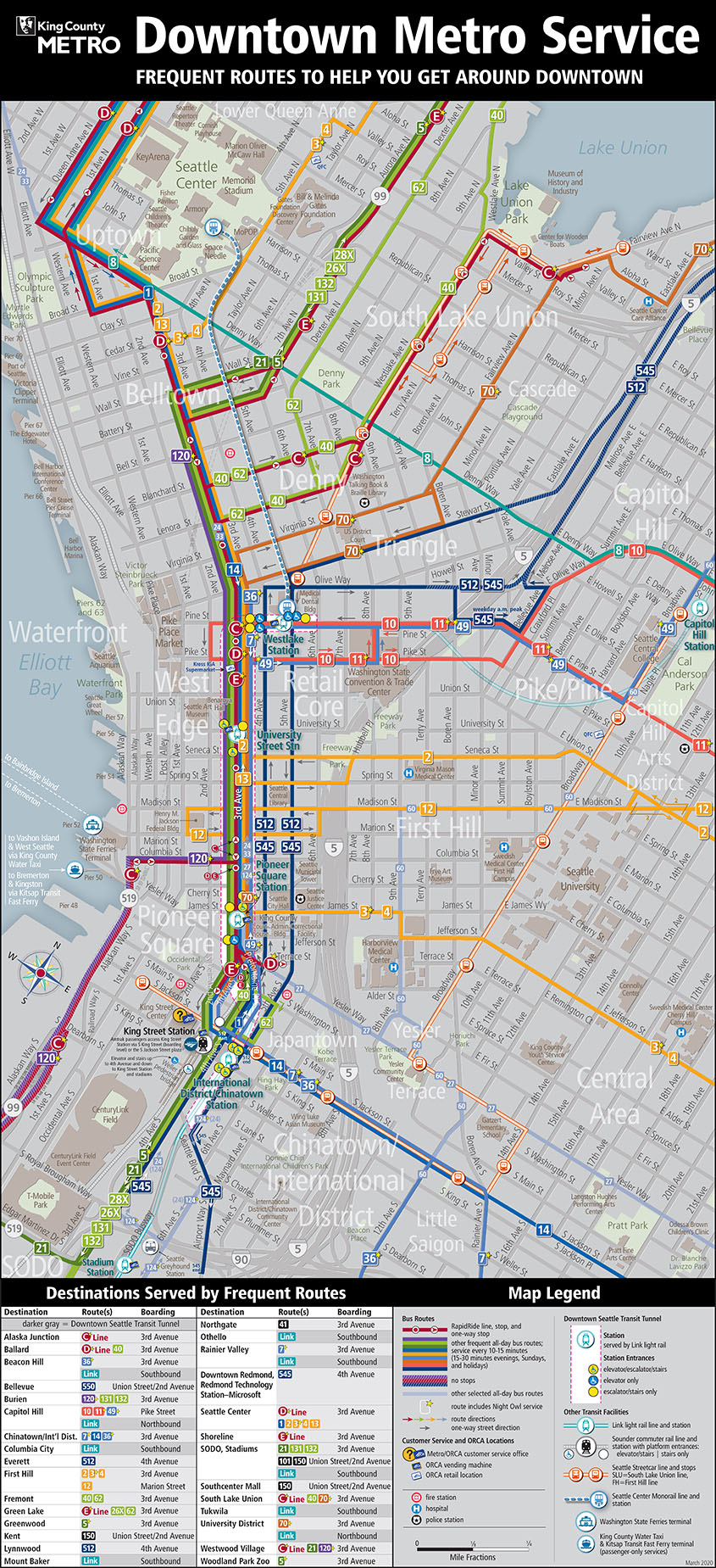
Capital Hill Streetcar
This is a great option, the downside being it is really slow compared to the LINK and even when exhausted, it’s probably faster by leaps and bounds to just ride. But hey, we’re talking about being super lazy here!
Starting in the Pioneer Square are, start at 1 to 2 is almost no hill, but provide two stop to board. Then 3 is up towards the midway point on the hill and near some pretty awesome asian food places! As is, of course 2 and the not shown stop between 2 and 3. Getting to 4 reaches the top of First Hill near the hospital zone. Which is great to deboard and then just downhill it to 12th, Broadway, or over to 12th to swing into any of those joints. Staying aboard though, while piddling the day away reading a novel or something, you can climb the next hill to point 5 and onward to the end of the link on Capitol Hill for the easiest of access via all downhill at that point.
Except of course for the final peak, of the second red rectangle from the first map. That one, is only accessible via hill cheats by boarding a bus and racking the bike. Some I tend to refrain from doing except at my most laziest (which is still pretty frequent). That’s where this next map comes into play, it’s a soup of buses and all that which King County Metro operates.
King County Metro Busses
On the above map, the busses that’ll get you to the very top (rectangle 2 in the first map), include 10, 11, 12, and 2. To get to the top of, if for example you don’t want to swing into the tunnel for the LINK or board the Capitol Hill Streetcar, First Hill board the 2, 12, 3, or 4. They’ll all get you up the super steep hills! Two other bus options that will get you into the 1 rectangle in the first map, include the 48 and 49 busses. If you’re aim is to just cheat yourself into a nice lazy ride to the 1 rectangle, any of these busses will work. Which means there are multiple places downtown that you can board, or from other points in downtown, to get up the hill without needing to put in any excessive amount of energy!
As a freebie, it’s also fun to just take the transit up, then have a downhill ride for the hell of it! 🤙🏻
That’s it for my Capital Hill cheats, I’m thinking about writing up Phinney Ridge or maybe Magnolia or Beacon Hill cheats next. Let me know if you’ve got a hill in Seattle you’d like cheats for and I’ll build up a list of routes.