After the grand trip across a vast expanse of the United States, I was finally approaching Pittsburgh! I’d been looking forward to visiting Pittsburgh for years now, so I was STOKED!
The day started at around 5am, as I pondered my arrival and the logistics of the situation on the train. I had some commentary, which I added in the VLOG. So be sure to check that out.
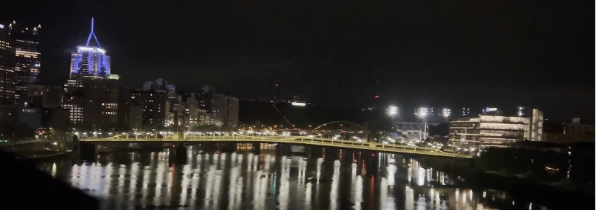
Then arrival in Pittsburgh. This image is from the train as we crossed the river.
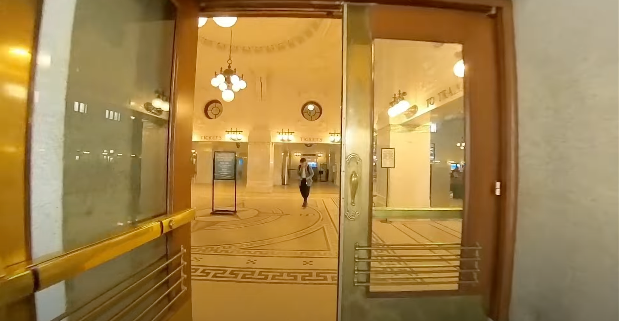
In the VLOG you get to see this some, but lets talk about the station in Pittsburgh. For the first thing to experience coming into the city, it is a major let down. It reflects horribly on the United States as a whole – as does our passenger rail in general – but this was an embarrassment of riches right here. The station is in what I’d consider the basement of what used to be the train station. The train station itself however is a bunch of apartments or condos, and the grand entrance is now just the entrance to those apartments. So the grand station that used to exist is now a basement with apartments – which you can’t really walk around – there are signs warning you not to, on top of that basement.
Overall, it’s kind of an insult to Americans to have taken a grand station of this nature, dumped the station into the basement, and stuck a few arbitrarily built – and likely very inefficient apartments in the once grand station.
It’s now kind of just a dump. It made me sad. But I digress, the adventure in Pittsburgh was just beginning and I wasn’t going to let the embarrassment of a station ruin my trip!
Pittsburgh Arrival Day 4 Part 1 – Arriving into Union Station & Initial Explorations.
Once arrived and finally detrained and out of the station, the mess that it was, I made my way out into the streets of Pittsburgh for an exploratory bike ride around the city. This became an absolutely stellar first experience in the city and more than made up for the dumpy station.
In this video I’ve got relive maps guiding the way so you can see exactly where I went, along with some stellar photos I took of the city. I rode up onto a bridge, through a kind of messed up, stinky, car-dependent part of the city so I could get these pictures and ALMOST DIED TWICE! I point that out in the video too, so if you are ever there, dear readers, be wary of the western bridge over the Ohio River! It’s got a sketchy approach on both side! Watch these next two episodes for that part of the adventure.
Pittsburgh Arrival Day 4 Part 2 – Arrived & Exploring the Ohio River “West Wend Bridge”!
Pittsburgh Arrival Day 4 Part 3 – Heading to south Pittsburgh to get some coffee & try to check in!
Finally, after all that exploration – from 5:30am to about 7:45am – I finally make my way form the north side of Pittsburgh over the the Travelers Rest, where I’d be staying for the week. I wrap up the day one VLOGs with the final check in, checking out Travelers Rest, and I show you the accommodations I’ve picked up for the stay!
Pittsburgh Arrival Day 4 Part 4 – Delanie’s & Travelers Rest. You GOTTA check these places out!
Back in April I took a trip to Pittsburgh, Pennsylvania. It is easily one of the best trips I’ve taken in a few years! Far too many years! Obviously I had to write up the adventure and that dear readers is what you have here, the log of my entire trip to Pittsburgh. I hope you enjoy following along with the adventure!
Along with the trip, which I’ll write details about here on this post and subsequent posts here on Transit Sleuth, another branch of posts will be on Vicious Shred concerning the record shops (Attic Records, etc) and music related peculiarities. So if you’re into the metal, and other varietals of music I partake upon, navigate over to Vicious Shred for a whole host of posts about that.
Day 1 – Departing Seattle via the Empire Builder
Day 1 involved departing Seattle. What did that involve? Well let me tell you!
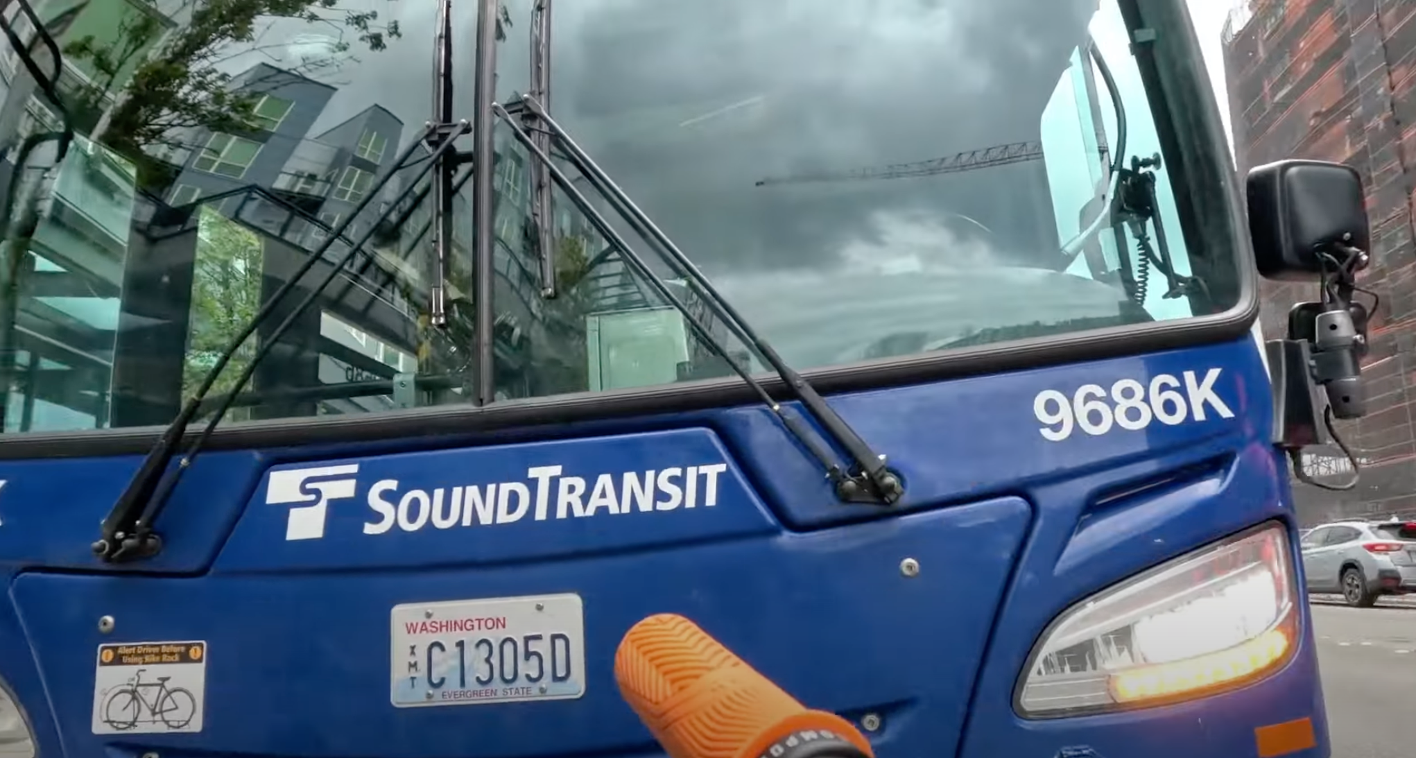
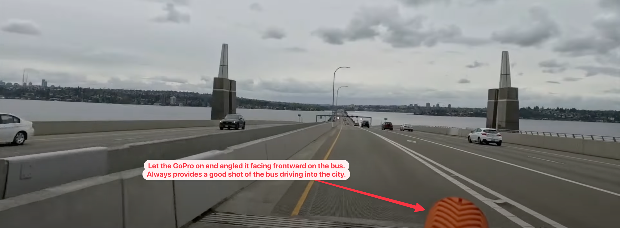
The very first event involved me biking down from home to downtown Redmond. There I caught the Sound Transit 545 out of Redmond heading to downtown Seattle & King Street Station. The bus arrived timely, I got the bike mounted up and off I went.
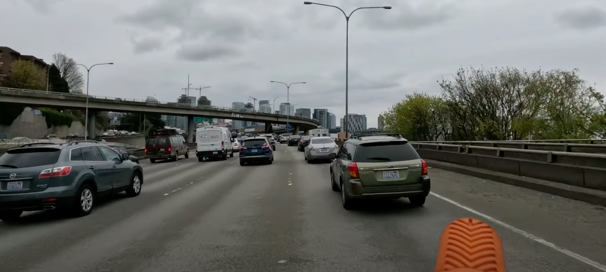
Shocker of shocker, as we got into the city there was a back up on 520 coming onto I-5, which is part of traveling on I-5. It’s always been backed up here and likely will always be. If someone is stupid enough to think they’ll resolve this poorly designed mess they don’t understand how cars work – and in that sense I am seriously looking forward to the day I can just on the tram (light rail) Link into the city!
Once I arrived downtown, I didn’t even attempt to ride the 545 all the way across the downtown core. There are two reasons I did got off the bus to travel this last few miles:
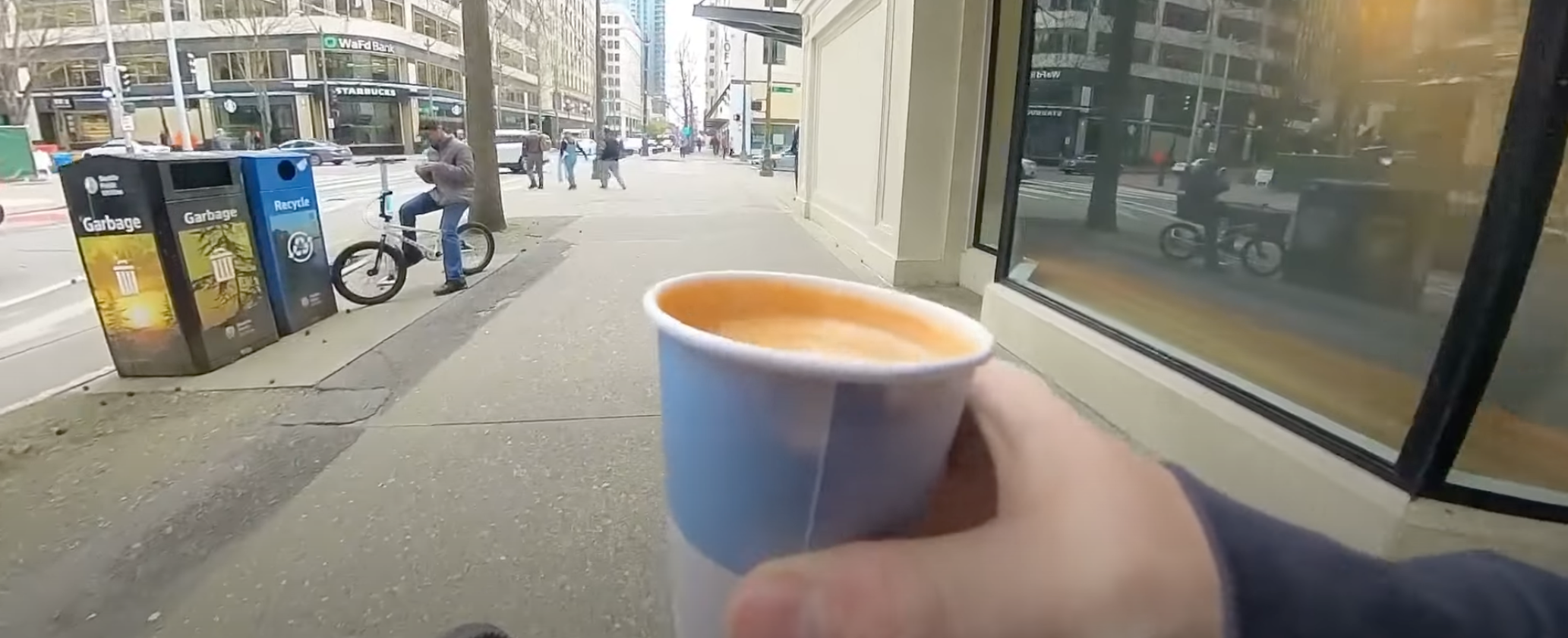
The main reason is I like to, as I’ve made it a tradition, to always stop at Monorail Coffee and get a cap before departure. For many – if not most – destinations in the United States it is likely the last time I’ll get a decent cap until returning. The espresso standards in the USA have improved to a degree so it isn’t as frequent I go without as it used to be, but I still don’t trust most cities.
The other reason is I actually like to ride through the city – I love cities, love em’! Some folks don’t get that from me but I see so much more than the mere concrete and fumbling crushed souls of the city and more the wealth generating heartbeat of America that US cities actually are. Albeit they’re severely damaged and have a severe quality of life issue compared to European cities. Largely evident in the vast warped subsidized American socialism experiment gone awry called “the suburbs”. But hey, they’re holding together the country in spite of all that!
Anarchist Jurisdiction
As the “Dear Leader” designated our poor fair destroyed obliterated city of Seattle, it is indeed destroyed y’all! Nobody come to Seattle, look at all that smoke and fire and burning, nobody is left! It’s all zombies and those lost in the riots. /s
Comedy aside, the ride through Seattle was rather pleasant. The roll – emphasis on roll because it takes almost no energy to pedal downhill from Monorail Coffee down to the train station – to King Street Station was smooth and effortless.
King Street Station
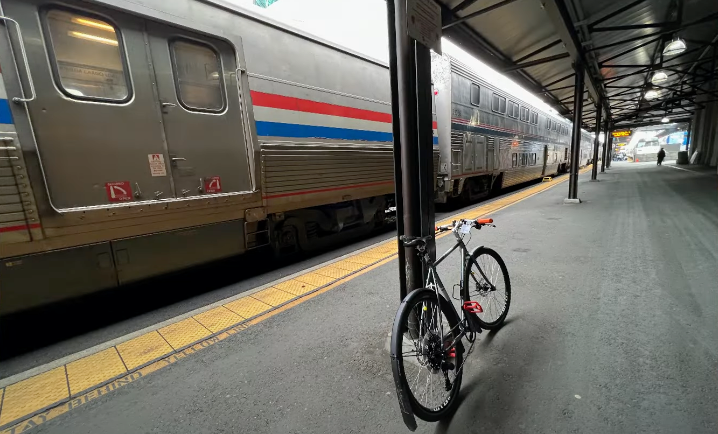
I arrived, got my bike tagged for the trip and headed off to the baggage car to hand off my bike. The only two things I brought with me was my Mission Workshop ARKIV Backpack and the bike (bounce back tothis post for details on why she’s named “PDX Orange”).
Tragedy Struck!
Chubby DOWN!!! You’ll have to watch the video for that bit of tragedy (time point @ the tragedy), it was already too much to write about the remnants of the destroyed city of Seattle! So with that bit of narration lagniappe, enjoy the video.
My Pittsburgh Adventure day 1 departing Seattle via King Street Station on the Empire Builder!
Day 2 – Eating on the Empire Builder
Day 2 can be summarized as eating day. There isn’t a lot to see or do on day 2, so it’s 3 meals and complete uninterrupted relaxation. In all seriousness it is one of my favorite days of the trip – even with the somewhat boring scenery – because I just do nothing. Maybe read, but mostly just thinking and introspecting against a repeating scenery. With that, I detail some of day 2 via VLOG for you dear reader!
Train Life, Day 2 on the Empire Builder from Seattle to Chicago, en route to Pittsburgh.
Day 3 – Empire Builder Transfer to Capitol Limited in Chicago
When I got into day 3, Chicago was the central action of the day. I needed to arrive on time or close to on time in order to make my connection to the Capitol Limited. The Capitol Limited route runs from Chicago to Washington DC. It makes a bunch of stops but my stop would be around 5:23am in the morning in Pittsburgh. If I had my preference, I’d have take another train that would have had me arriving in Pittsburgh at a more reasonable hour, but this being America we have a severe lack of transportation options between major cities!
The great thing about – in my humble opinion – coming into Chicago is getting into the urban fabric and watching the urban core and its skyscrapers start to rise out of nothing. If you’re privy, you get to see a lot of history as you roll into the city too. If you find that kind of thing fascinating Chicago is a city worth looking into.
In this episode I wrap up things by showing the path and process – for my brave fellow cyclists out there – of getting your bike stowed in Union Station. If you’re in the sleeper or 1st class like I was, you get to hang out in the awesome lounge at Chicago but you need to stow your bike in the meantime.
Pittsburgh Adventure Day 3 – Part 1 – Arrival in Chicago & wondering around Union Station.
In the 2nd part of day 3, transferring in Chicago I provide a tour of the 1st Class Lounge and then wander aimlessly around Chicago for a short while. Then I show boarding, which is a bit of an adventure in fumbling since I have a bike. Even though this is actually an easy process, you need to stay on top of things in order to make sure the bike does end up where you end up. Follow along in the VLOG to see more of the chaotic fun as I wrap up the Chicago transfer to the Capitol Limited!
Pittsburgh Adventure Day 3 – Part 2 – Transferring in Chicago & wondering outside Union Station.
That’s it for the Empire Builder part of the trip, in my next post I’ll delve into arrival day in Pittsburgh and the ongoing adventures!
I’ve given myself another transit and biking mission in addition to the upcoming posts on the Pittsburgh “Record Recon” missions. Find and recon the record stores in the Seattle “metro” area (obviously right, because I live here!). That includes a lot of territory and I’ll break down with maps and logistics where each of these record stores are and in the coming weeks I’ll be producing a series of videos on each of these shops.
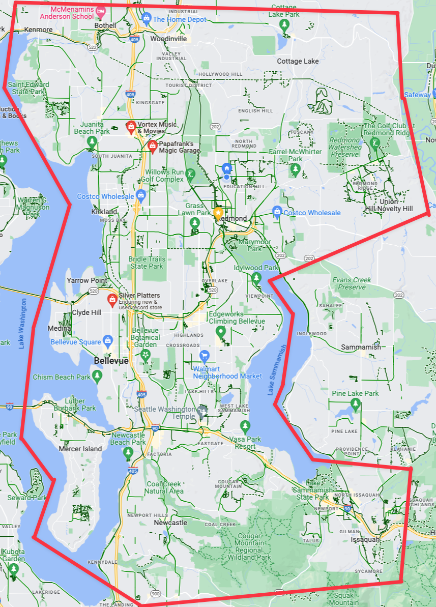
The “Eastside” of the Seattle “Metro”. (Click for larger viewable map)
Now if you’re more interested in just reading about my music collections, reactions to new music, reviews, and all that then check out Vicious Shred. Between that blog and this blog, I try to segment my music specific things from my transit, transportation, and traveling adventures. With that said let’s roll on the record recon!
The Eastside (Seattle “Metro Area”)
Bellevue, Redmond, and the east side in general. This includes the area in the giant pink area. One could generally say “the area between the two major lakes of the area and the wooded northwestern lands of Redmond and Woodinville”. Not that a lot of that area is relevant because the east side simply does NOT have many record stores. However, there are a few, as you can see, which we’ll dive into.
The three record stores (garages?) on the “Eastside”. (Click for larger viewable map)
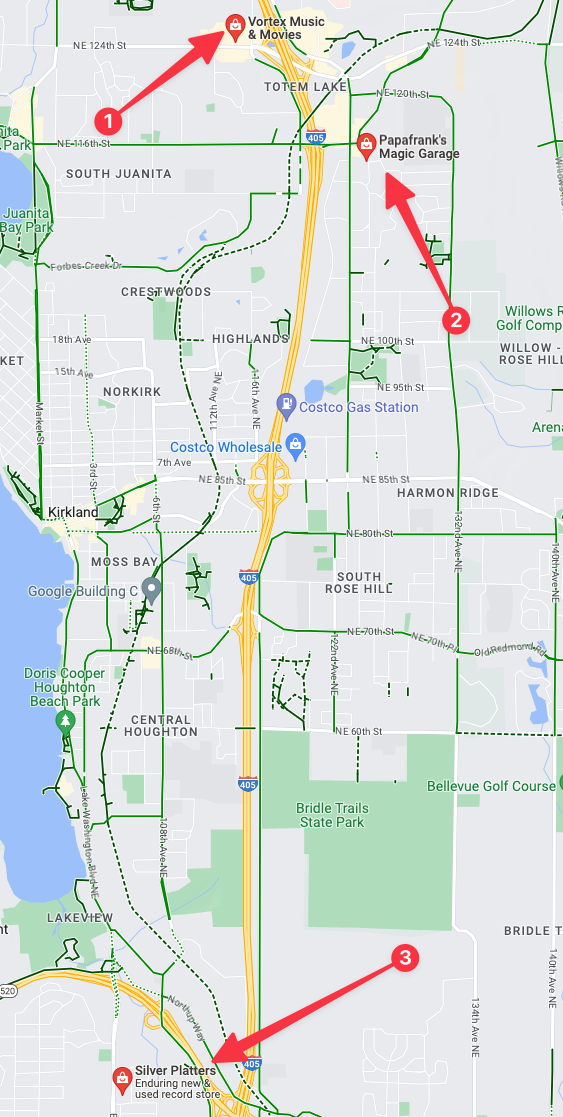
If we zoom in on the available record stores for the east side they’re all in two places, one is in north Bellevue and the others are in the Totem Lake area. There are only two efficient ways to get to these two area: 1 drive to either of them or 2 bike to either of the locations. Neither are walkable without multiple hours of free time to get to and from them unless you’re located directly inside of these specific areas. Fortunately in *these* suburbs I’ve got some excellent bike route options to get to both locations.
The second option, “Frank’s Garage” is literally Frank’s garage located in a suburban single family home off of any commercial corridor. This is super cool, but also I’ve noted that Frank’s “store hours” are only 1-5pm on Sunday. So that might have to get nixed if I can’t make this trip on a Sunday.
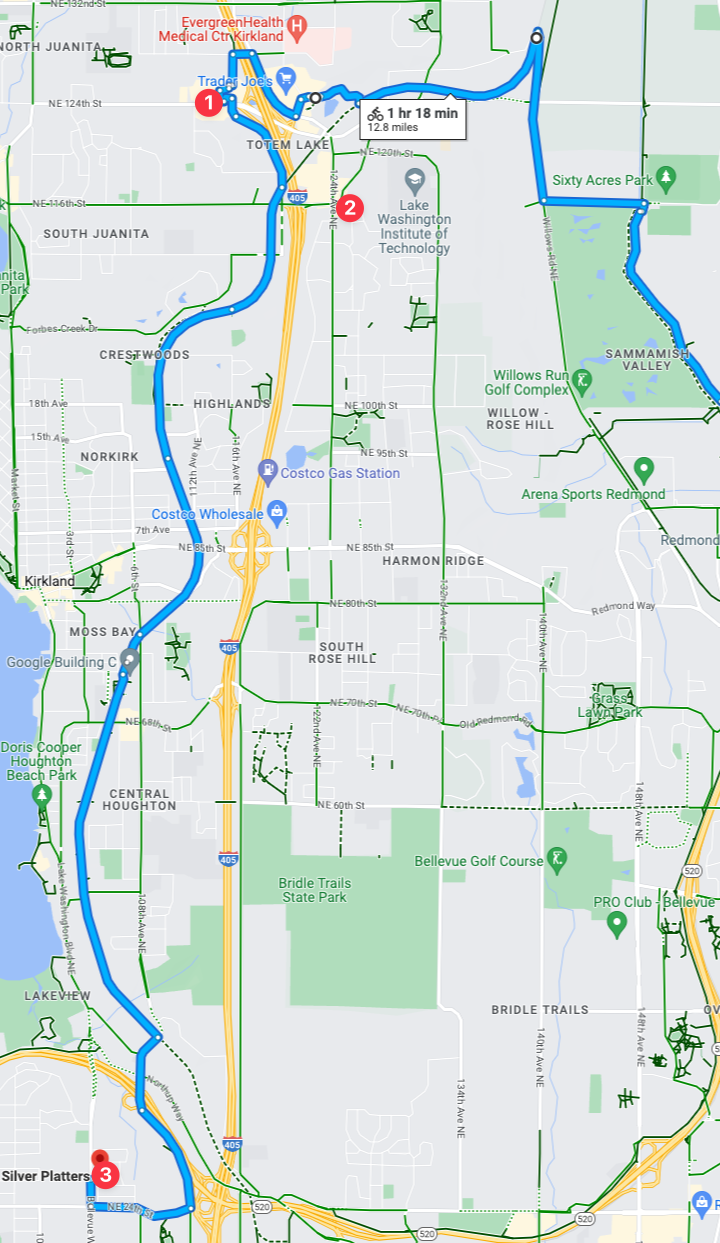
A key bike route is along the Cross Kirkland Corridor, which perfectly maps to nearby locations of all three of the record stores! This means that I theoretically could visit each of the record stores in one trip, efficiently stringing them all together in one voyage! Note that time, I’m going to set myself some specific challenges for this voyage:
Ensure the trip time is less than 1 hour and 18 minutes. Think I can accomplish that? I’m pretty confident I can beat that.
Check out both “Vortex Movies & Music” and “Silver Platters“, and for this first voyage to Eastside record stores I’m going to skip Frank’s since I can’t make a Sunday trip.
With that, this I’ll dub “Mission 1: Seattle Metro Eastside Record Stores Voyage“. But with the Eastside locations covered, let’s move on to the *actual* Seattle record stores.
Seattle (The actual *city*)
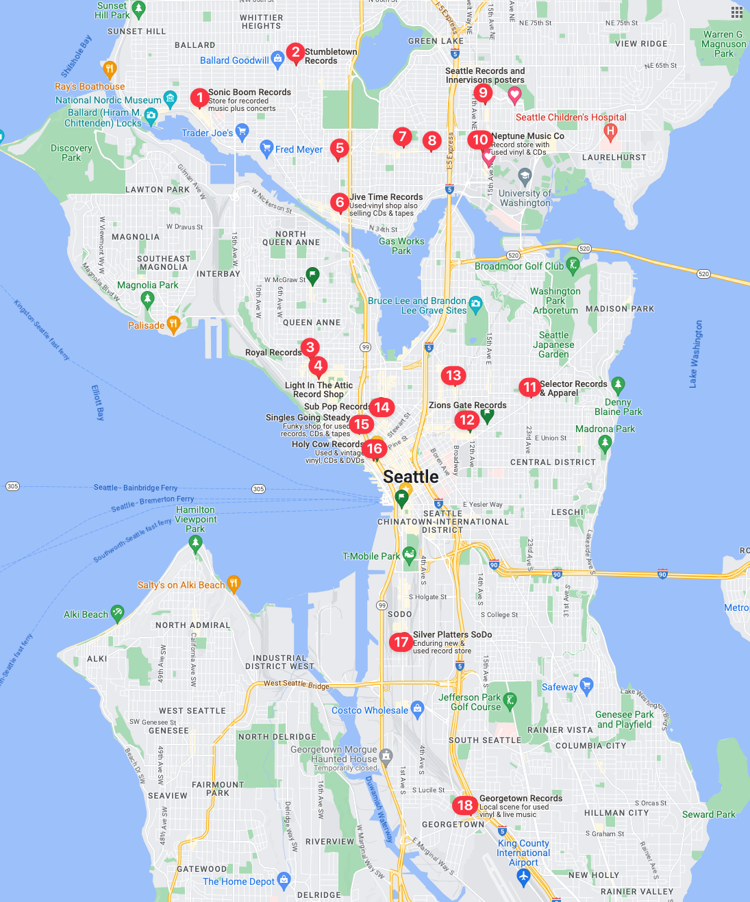
18 Record Shops – That come back in a maps query. There could be more, and if I zoom in…
My first observation, is that there are none in West Seattle, which seems really odd. I’m finding it hard to believe there isn’t a record store over there, as I’m 100% positive that Easy Street Records & Cafe is over there. Which, I’ll get over there for a full review in the coming weeks as it is easily one of the best record shops in the country let alone Seattle.
I’ve done a secondary query and there is indeed multiple record shops that don’t show up in the above, with the addition of Easy Street Records & Cafe showing up in a query of just West Seattle. Then I did another deeper zoomed map query of University District and sure enough, several additional record shops showed up: Neptune Music, Hi Fi Lo Fi, and Al’s Music, Video, & Games in addition to the two shown on the map above.
This is going to be multiple missions compared to the Eastside, as there is no single route that would travel through all of the record stores as there are just too many of them. But with a bit of study and logistical prowess I’ve attained from years of cycling all over Seattle, I’ve got a few plans following a few strategies.
With those extra queries, the 18 record stores in the map turn into 22 stores in Seattle proper! Clearly, if you’re into vinyl and live in Seattle you’d never have to leave the city, it appears Seattle has record store coverage almost everywhere! With 18 stores I’m going to guess I can maybe drop into 3-6 stores per trip, but it could very well be just 2 or more depending on which ones I’m aiming for. Based on routes and clusters of record stores here is the first two that I’ve deemed a priority.
Mission 2
Mission 2 record reconnaissance will be into the University District of Seattle with a goal to visit 4 stores: Neptune Music, Hi Fi Lo Fi, Seattle Records and Innervisions Posters, and Al’s Music, Video, & Games. There is another store that has theoretically opened at 6215 Roosevelt Way NE called Satisfaction Records & CDs that I’ll roll into this mission. It was in Ballard, but as I searched through the characteristics of that mission I had to back track and add it to this mission! Thus, it’s very likely this will be a recon mission with 5 stores!
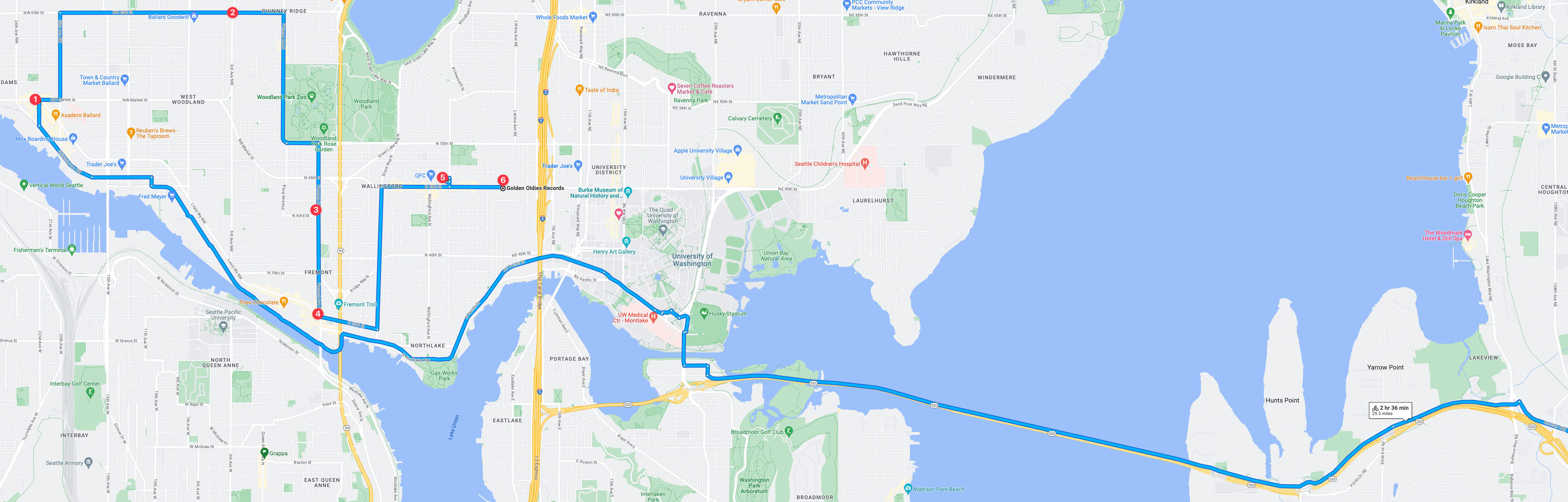
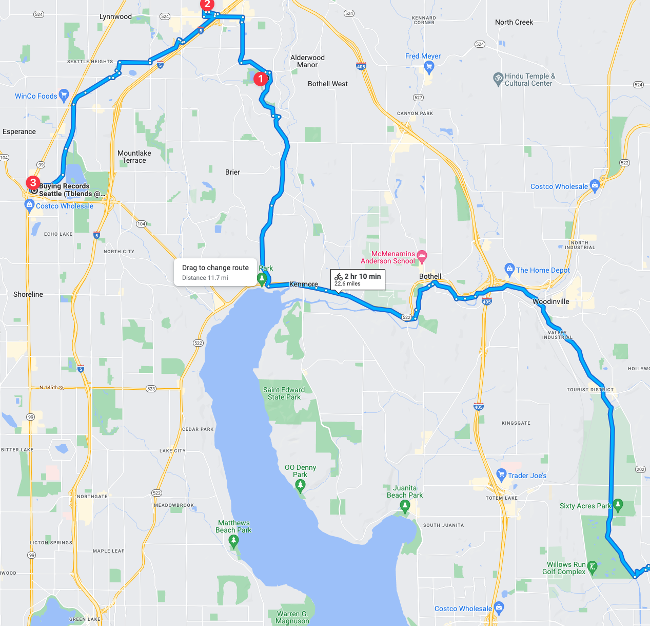
Mission 3
Mission 3 record reconnaissance will be into a trio of neighborhood areas: Wallingford, Fremont, and Ballard. This is extremely familiar territory since not long ago I lived in Ballard and also long ago I lived in Ballard. This reconnaissance run will be the hardest to date at this point with 6 record stores to visit! Will resources be enough? Will time be available? Will the store open hours be enough? It could be tricky but I think I can pull off 6 stores in one trip!
Overall, this mission holds a special place in my heart and mind as it’s in old stomping grounds of 2022 and before! In many ways I do miss Ballard and wish we could have stayed in the neighborhood but alas, to the east we went. But just before we left, one of the old well known record stores closed, which this trip will be a hats off homage to the long years of service of said store – if you know you know. But either way, this trip is gonna be fun to record and fun to log the visits afterwards.
Mission 4
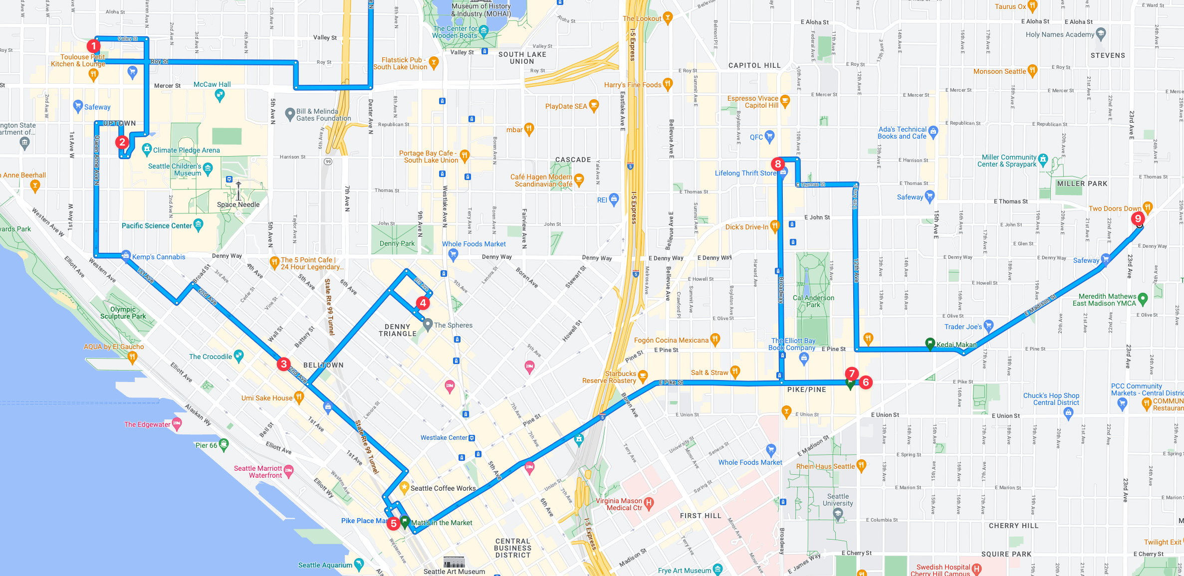
Mission 4 is going to be intense, and I might have to split it in two considering the 9 record stores to recon! I like to spend at minimum 15 minutes checking them out which would put just the time in store at 135 minutes minimum, but likely will be more if even one of. the stores has a great selection that I need to recon more intensely. My personal estimate with that many stores, it would add at least 3 hours or more to the entire recon mission just based on in store time.
Mission 5
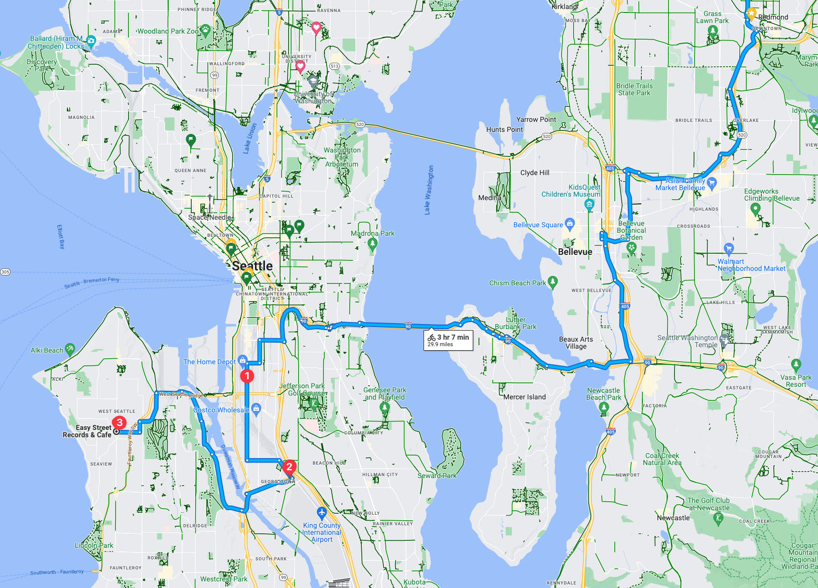
This mission will include a nice trip, albeit long at 3 hours and 7 minutes, it’ll be beautiful ride and an absolute shit ride. This recon trip includes three record stores. One being the Silver Platters SODO location should be pretty good. Then followed with what I understand (and know) to be two of the coolest parts of the city with two a respective awesome record store in each neighborhood.
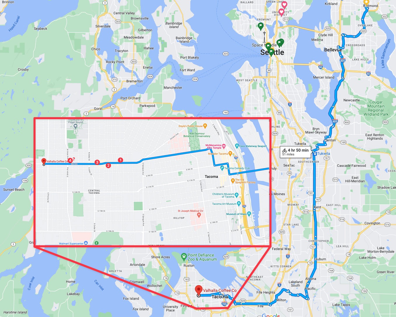
Tacoma (Not Seattle, but I had to include it!)
Mission 6
Mission 6 could be so intense from a trip distance, I might just need to interject a train into the mix! After all, trains leave from downtown Seattle and go straight into Tacoma, which would make this trip exponentially easier! But when the mission is on the calendar I’ll narrow it down and confirm the logistics.
Mission 7
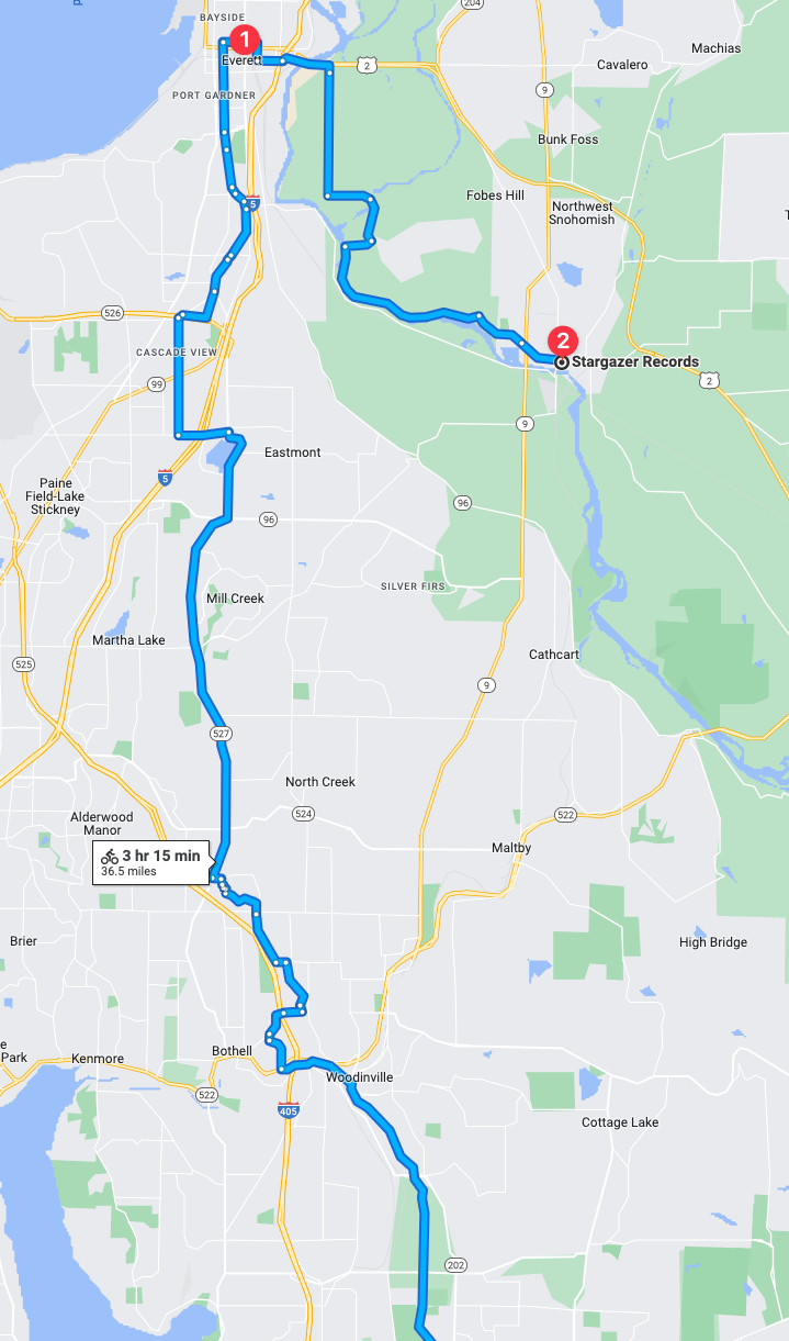
Seattle “Metro Area” North is a string areas north of Seattle and south of Everett. I’d go into detail but it’s unnecessarily complicated. Suffice it to say, this trip is going to be long at a suggested 2 hours and 9 minutes, with a significant amount of the trip via trails, amazing. There is still about 15-25% that is on roadway “bike infrastructure” which, in this area, translates to shitty car sewer stroads. But I’ll make due, this is going to be a very interesting recon trip. It’ll also be really interesting if the record stores will validate the trip effort! Hopefully there is a jackpot or two to find among the two.
The other thing that isn’t immediately noticeable in this trip is how much of the trip is actually dedicated trails! There are of course some roadways but significant portion of the trip is extensive trail routes! I’m really looking forward to that aspect of the trip.
Mission 8
In mission 8 the route is about 50% trail and 50% car sewers so that is going to be a bit of a challenge. Either or though, at some point I intend to complete this mission! These two stores seem fascinating and could be interesting collections unto themselves.
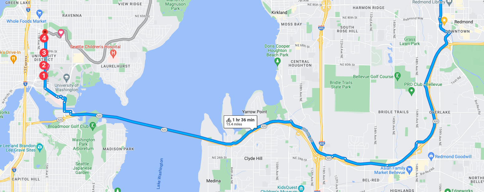
☑️ Mission 1: Seattle Metro Eastside Record Stores Record Recon
This is a consolidation post to catch up with the ole’ VLOGs, so this is going to be a short and sweet summary of the VLOGs I shot for the:
Eastside Bakfiets Bijeenkomst
In this episode it’s off for a trip down to the Spring District of Bellevue WA for a “Bakfiets Bijeenkomst”. Translated that means “box bike meet”. For details on our future meetups, check out the Bakfiet Bijeenkomst details here!
Bellevue to Mercer Island to Seattle Long Form Video of the ride
This is a one off long, long, long video of almost a complete ride. I depart from the Bakfiets Bijeenkomst and ride up through Bellevue, across the Interstate 90 Bridge, across Mercer Island, and into Seattle. 0:21 the ride begins, departure from the cargo bike meetup.
Grub @ Burgermaster & chilling in the Spring District
On the ride home from the previous episode I stop in at the Burgermaster for a bite to eat. Join me for a stop there, then a ride back over to the Spring District to enjoy the burger and some introspection. 0:21 On to Burgermaster. 1:07 Going full aero on the cargo bike! 1:38 Gettin’ a burger at Burgermaster. 2:03 I chat with the fella that strolled over to take my order. Love how they take orders here, it’s fun. 4:06 The map of the route from Burgermaster to Spring District that I took. It’s the monster uphill onto the Cross Kirkland corridor right here, but with the Riese & Müller Load 75 it’s a simple walk in the park! 5:09 Back at the Spring District I opted for this cool public space and the marble table! This table is NICE! 5:10 Diving into a bit of introspection and pondering about this Spring District area.
I used to live in Ballard, and the bike trip into Seattle was about 26-27 minutes to the Pioneer Square area, and maybe similar or a few minutes more to anywhere in the central business are including South Lake Union. I have however moved out to Redmond which makes for a vastly longer and more significant trip.
For a ride into the city on Spacey or Pop Rocket it takes about 90-135 minutes to get into the city core or on to King Street Station and Pioneer Square area. Not so much because of distance but because of the half dozen plus hill climbs coming into Seattle from Redmond. However if I circumvent most of the trip and load the bike on the 545 I can get into most points in a reasonable 45-65 minutes. On my Reload bike it’s a whole different story, as the hill climbs are largely nullified and the downhills, I routinely exceed 30 mph easily, which brings the trip in at a consistent 75 minutes to almost anywhere in the city center or Pioneer Square.
The following VLOG is about that ride, and for this specific ride I branch off and head to north Seattle, back to G & O Cyclery to pick up a 2nd pair of batteries for Reload.
Transit Nerd Points Along the Route
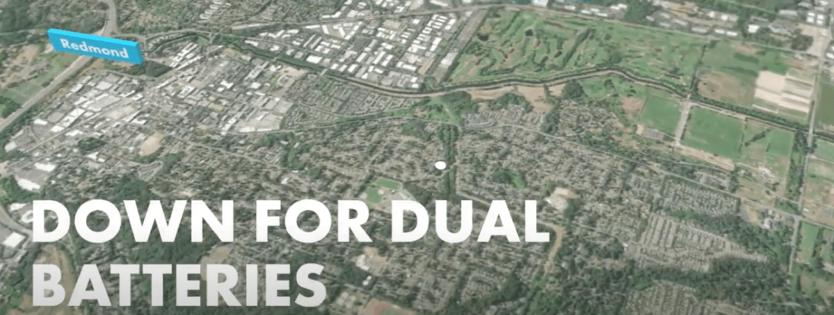
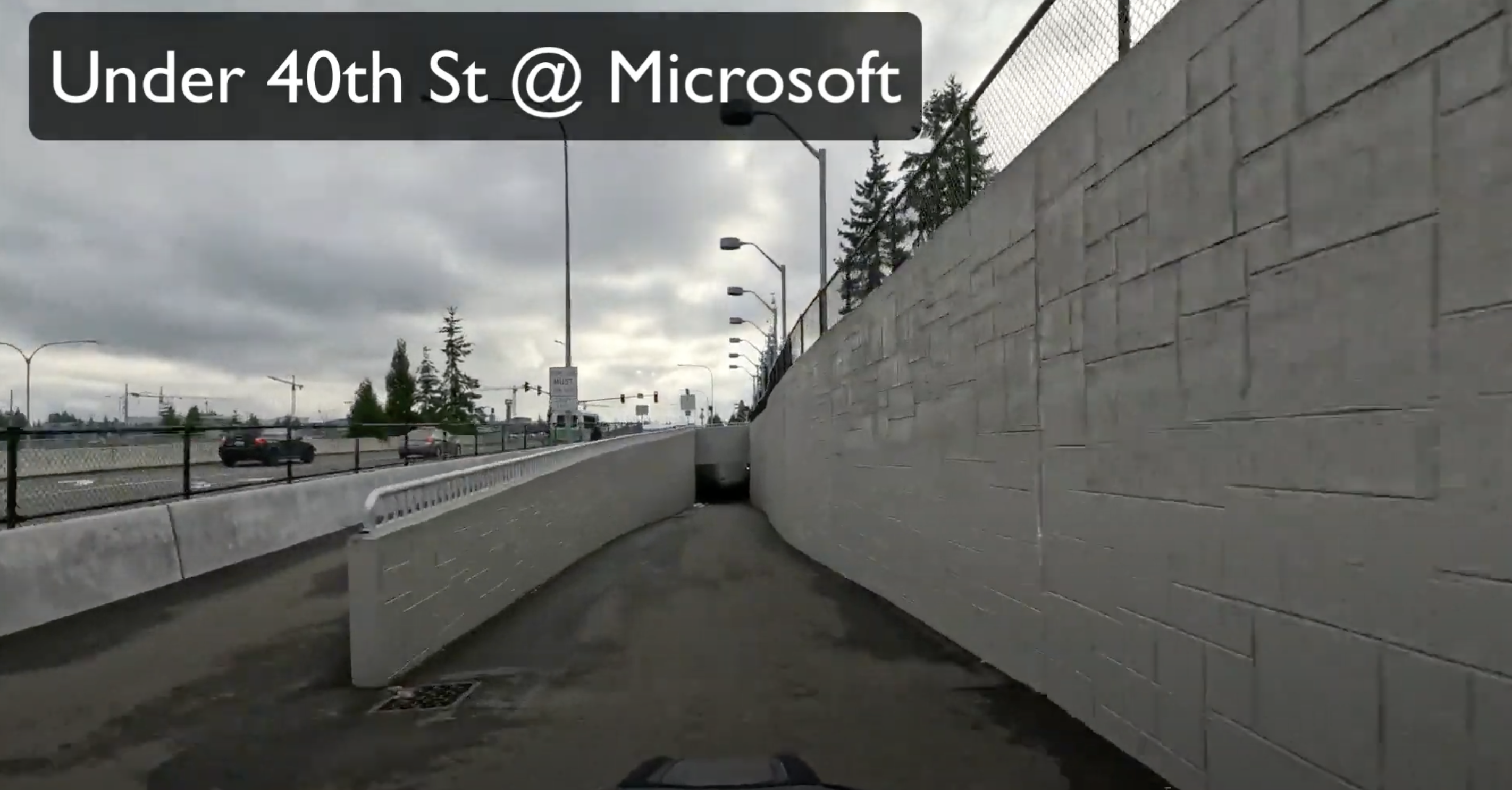
The intersection of 40th street in the midst of the Microsoft Campus has always been an utter calamity during commuting hours. Even today as people do start to return to the campus for work, the rush hour time frame can become a mess. As you can see in the picture above though, there’s now a tunnel for the 520 trail that goes under the intersection – entirely bypassing what was sometimes a 2 minute delay for a single intersection. For drivers, it’s still an utter mess, and the on ramps on both sides routinely are backed up down onto the 520 highway for a mile or more. The cross street (i.e. 40th) is also a bit of a mess, with cars backed up in odd ways off onto side streets and 148th nearby.
The simple fact, automobiles are the worst way to transport any volume of people through the area, which makes it obvious when you see the stats why most people arrive at this intersection via transit. The Overlake stop on the opposite side of this intersection to this 520 trail tunnel is often packed with arrivals just from the 545 alone, however many other buses arrive there (542, etc) for a significant number of persons in and out of the area. The 520 path also provides access to much of the Microsoft Campus which delivers a ton of folks.
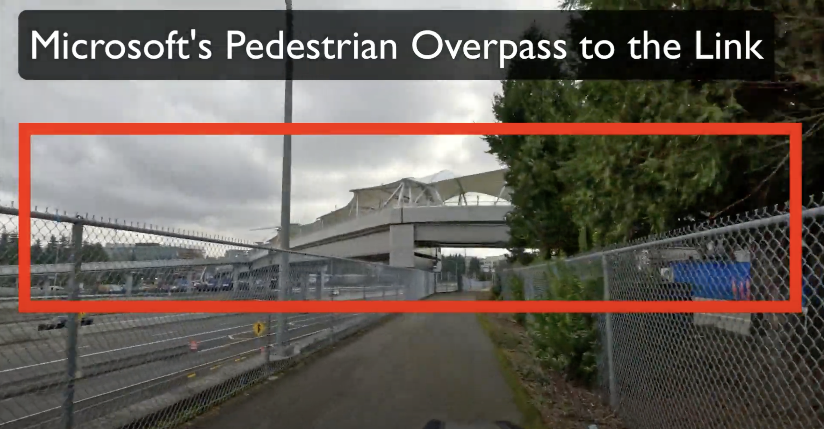
Eventually this stop will be a significant stop on the Link Route from Bellevue to Redmond. You can see the massive pedestrian overpass that Microsoft has built too, which connects the existing central campus hub (I forget the name of this, Softies what’s the name of this area?) to the new urbanized area on the eastern side of 520. This overpass for pedestrians has all those tent coverings, albeit permanent tent coverings, to cover the pedestrian path, which makes for a rather interesting site as you come along underneath it. The offshoot of this path, which you can see in the picture on the left hand side, is what will provide a way to and from the Overlake Transit & Link Station.
Overall, this intersection and a few others are the primary arrival points for people to Microsoft Campus, which their pre-pandemic metrics showed only 60% – at a suburban campus – arrived by automobile. The other 40% arrived by alternate modes such as transit, bike, or even just walking to campus. For a suburban campus like Microsoft’s this is significant and impressive. Albeit, for an urban campus it’s absolute garbage to have 60% arriving by car, but I’ll give Microsoft a win in this particular situation. As the return to office accelerates at Microsoft, that ratio seems to be holding, if not increasing for alternate modes.
24th to Lake Washington Blvd
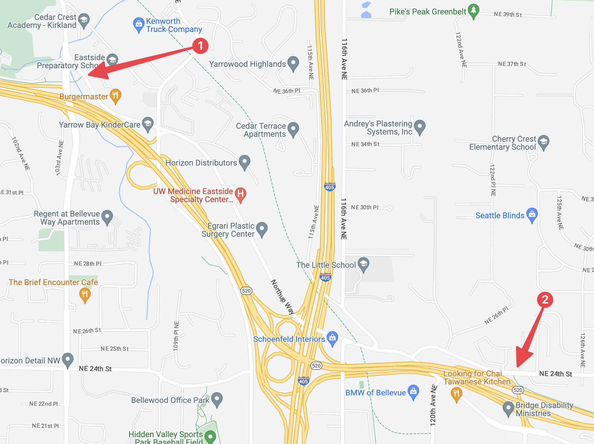
At 2:26 I roll into the segment of the “520 Trail” that is largely bike lanes in the road – albeit I discuss the alternative of just using the largely unused sidewalks that are clearly separated from the roadway. In the map image below I tagged the ingress and egress points for the part of the trail with 1 and 2 respectively.
This part of the trail isn’t all that bad really, albeit being a car sewer amongst pleasant interlined streets is a bummer to be forced to deviate onto, one at least gets to entirely bypass any conflict with 520 or Interstate 405. The connection to the Cross Kirkland Corridor however leaves much to be desired, as you’ve got to back track all the way down 120th to loop back around onto the trail. Depending on which way you want to go this can be rather bothersome or work out to your favor, but in either case one has to make sure to note the points to turn onto Northrup Way and then onto 120th. I’ve found it to be somewhat confusing the many times I’ve been by and only recently – after dozens of trips – have I gotten it into my head where and which road to turn onto.
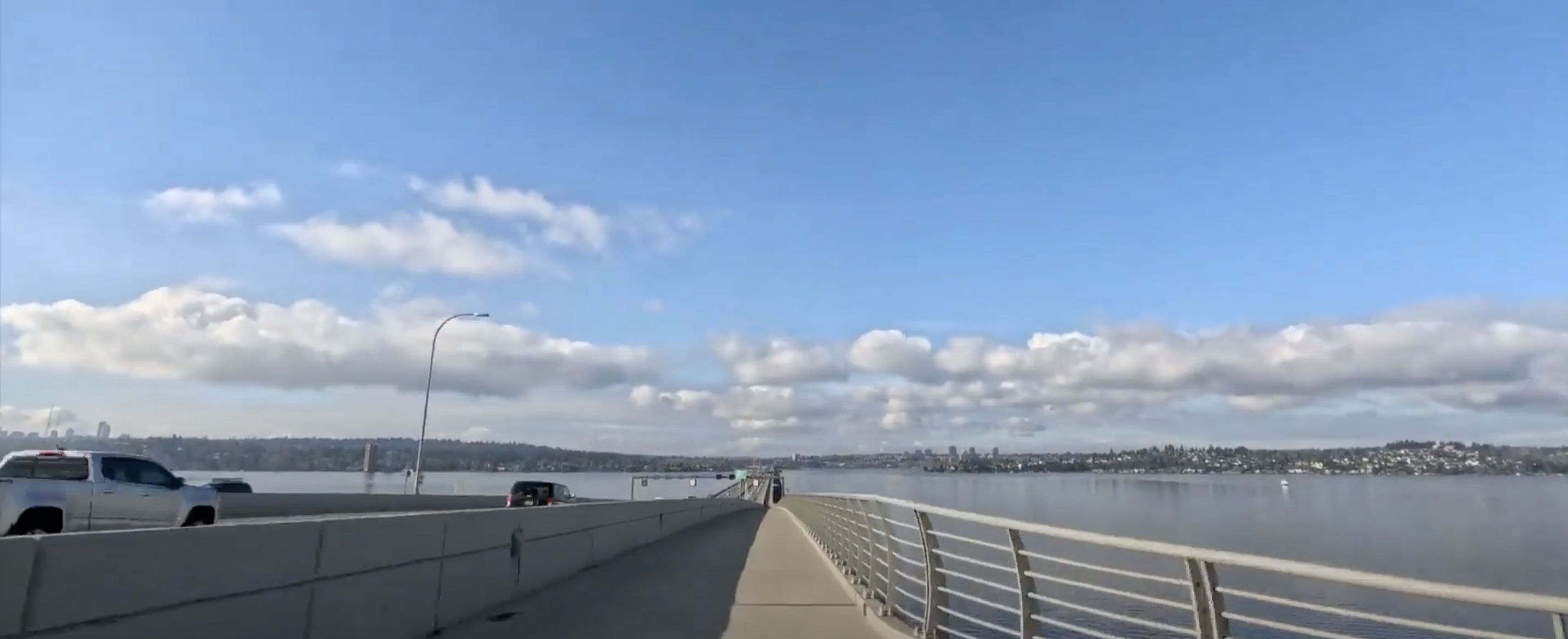
520 Bridge Trail
The 520 Bridge Trail is a superb piece of bike infrastructure, the only thing I’d say it needs to make it even better is a sound barrier like the Woodrow Wilson Bridge has in the Washington DC metro crossing the Potomac. It almost entirely cuts out the incessant, bothersome, and droning of the cars going by on the bridge itself. They’re loud, and as always, being near a major highway like this can be extremely annoying. The fact there are points along the bridge that are scenic overlooks cracks me up as it’s almost headache inducing to stop at them – in spite of them being nice. However, in the end, it’s a barrier divided piece of infrastructure which provides a very safe and seamless way to get from the east side into Seattle proper!
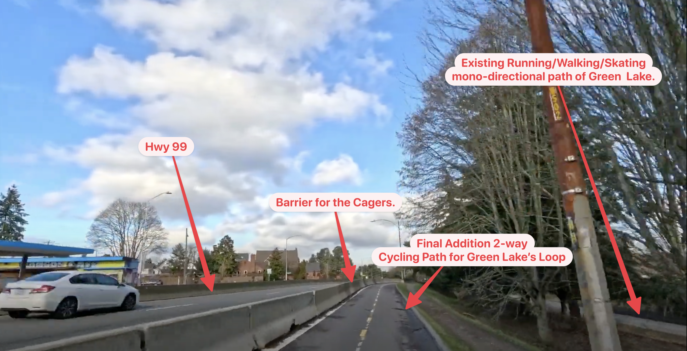
Green Lake Loop
Around 11 minutes into the video I get to have a first ride along the newest and final segment of the loop around Green Lake.
For the inbound trip, that about wraps it up. For more commentary and the ole’ “moving picture” give the VLOG a watch.
Episode 36 – Bike Life. Riding into Seattle via the 520 Trail to pick up some secondary batteries for my R&M.
For more details on Reload, the bike I’m riding, check out my Riese & Muller Load 75 write up here and here.